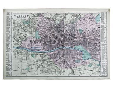
Bacon's Map of Glasgow
This plan of Glasgow was published in Bacon’s ‘New Large Scale Ordnance Atlas of the British Isles’. Condition & Materials Lithographed town p...
View full detailsThis plan of Glasgow was published in Bacon’s ‘New Large Scale Ordnance Atlas of the British Isles’. Condition & Materials Lithographed town p...
View full detailsThis map of Liddesdale, in the Scottish borders, is from Golden Age Dutch cartographer Blaeu’s Scottish atlas. First published in 1654, the atlas w...
View full detailsOur example of the map has been annotated in ink to show the early expansion of the railway system, with railways completed and under construction....
View full detailsMogg’s New Map of the Roads. A New Travelling Map of England, Wales and Scotland […] Condition & Materials Copper engraving, 77 x 63.5 cm, a ro...
View full detailsDas Irische und Kaledonische Meer mit Seinen Inseln This map focuses on the islands off the coast of Scotland and in the Irish Sea, and it's from f...
View full detailsCheffins’s Map of the English & Scotch Railways Cheffins’s Map of the Railways in England & Scotland, accurately delineating all the lines ...
View full details