


Leslie George Bullock: cartoon maps for children


L.G. Bullock was born within sound of Bow Bells - “if the wind was right”. He was educated at Alleyn’s School, Dulwich, and afterwards joined the Territorial Army and saw service in the first World War. He entered the Civil Service in 1920, and worked in London, particularly with the Port of London, until 1932 when he was transferred to Scotland. In the last war he was attached to the Home Office on A.R.P. and Civil Defence duties, and was awarded the O.B.E. in 1948. Now retired he lives in Kent - as he says, not too far from London. As well as a version of the children’s map, folding onto the lower pastedown, The Children’s Book of London also contains a number of double-page maps such as this one of the City:  Here are a couple of Bullock’s other works:
 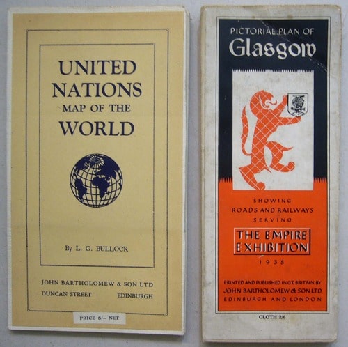 His Pictorial Plan of Glasgow, prepared for the 1938 Empire Exhibition, is roughly contemporary with his Children’s Map of London, and it seems to be among his first published works. I have not yet located anything earlier. It is very much in the same style, though without the whimsical quotes and cartoonish figures. It would certainly serve as a practical plan, as well as a souvenir, for any one of the exhibition’s 12 million visitors.
  Bullock’s United Nations Map of the World was published in 1948, a wonderful example of postwar optimism.
  As well as carrying the coats of arms of member states, the map is liberally adorned with improving classical, biblical and literary quotations, and substantial extracts from the Atlantic Charter and the United Nations Declaration. Many cartoon and satirical maps were created by successful commercial artists, MacDonald Gill being an obvious example. I looked in vain for other example’s of L.G. Bullock’s published work, but now I know why. He was a civil servant - his maps for children were a private passion.
----------
Update
This post was written almost a decade ago, in 2014. Time for a few more thoughts on Bullock’s maps for children. My colleague Rod Barron wrote a splendid biographical post in 2015, in which he also gave the correct year for Bullock’s birth (1895; Rod is quite right, if born in 1904 he would have been the youngest officer in the wartime RFC/RAF). But I think we can still find a few new things to say about the man and his maps.
Few pictorial maps have enjoyed the commercial lifespan of Bullock's Children's Map of London: first published in 1938, generations of children pinned it to their bedroom walls, and it was still part of its original publisher's list 40 years later, in the 1970s. MacDonald Gill's Wonderground Map of London Town made its debut just before the First World War and was still being advertised into the 1930s, but Gill tweaked his map to keep it relevant (for example, adding a lion and then replacing it with a greyhound to represent the British Empire Exhibition and then the new dog track at Wembley). Bullock does not appear to have changed the design of his map at all.


Bartholomew, Bullock’s publisher, did update the cover. Here they are together: from left to right we have the original 1930s cover priced 3/6; an example (issued postwar?) with a revised price of 5 shillings pasted over the printed price; the same cover design but folded in a slightly large format, circa 1960; a new cover design with a friendly Guardsman, introduced circa 1969, and finally a cover showing a mounted trooper from the Household Cavalry dating from the 1970s. The firm evidently considered it worthwhile to give an old favourite a fresh face. Bullock was interviewed by the Kent & Sussex Courier (4 April 1969) at the time of the publication of his final printed map, his ‘Historical Map of London’, and he remarked that his maps were still selling ‘like hot cakes at Expo 67’ (a World’s Fair held in Montreal). Perhaps a clue to their success can be found in what he was reported to have said next: ‘Mr. Bullock says his maps are for “ordinary people.” “They are not intended for scholars, and I don’t go in for the finer points of history,” he said. “But the general public seems to like them. I have been told that all public libraries in the State of Baltimore in America have copies for general perusal.”’
I was intrigued to learn from the same article that the maps we know about are just the tip of the iceberg. Bullock mentions completing over 100 maps, with ‘several up in the attic, and a lot more on the walls of my rooms to brighten things up’, but many were never published: he ‘observed cheerfully’ that his map of the British Commonwealth ‘would have been out of date and inaccurate before the ink was dry’. Quite the reverse, in fact, of his timeless children’s map, which is presumably why he never felt any need to revise it.
Some of his unpublished maps were commissions. Bullock lived in Langton Green on the outskirts of Tunbridge Wells. He drew a map of his local parliamentary constituency, Tonbridge Division, which took him two months to complete and which was presented on retirement to the outgoing MP, Gerald Williams (reported in the Kent & Sussex Courier 12 April 1957). The same article mentions another local map, which stood in the Bennett Memorial School, Tunbridge Wells - perhaps to mark its opening in 1953.
We’ll never know the fate of many of the unpublished maps, but I’m prepared for surprises.
Leave a comment