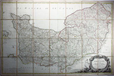
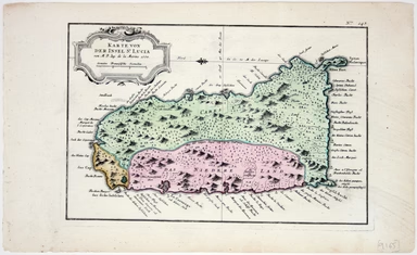
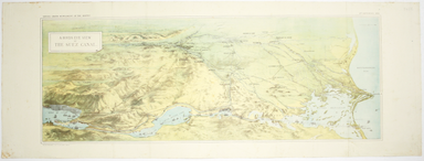
18th Century Folding Map of Normandy
Carte de la Normandie, divisée par Generalités et subdivisée par Elections Condition & Materials Folding map of Normandy, 68 x 102.5 cm, origin...
View full detailsCarte de la Normandie, divisée par Generalités et subdivisée par Elections Condition & Materials Folding map of Normandy, 68 x 102.5 cm, origin...
View full detailsA July 1910 map of the Uptown and Downtown Hudson Tubes, pairs of tunnels connecting Jersey City with Greenwich Village in New York and with the Hu...
View full detailsThis is an interesting example of the London underground map produced under difficult wartime conditions. A number of variants of this map were iss...
View full detailsThe introduction of Beck's diagram did not obviate the need for geographically accurate maps, which pinpointed the location of Underground stations...
View full detailsLondon: Day & Son for FG Moon, 1842-45. Tinted lithograph by Louis Haghe after Roberts, 33.5 x 53 cm, slight marginal waterstaining. From the ...
View full detailsChart of the South East Coast of Arabia from Ras Sukra to Palinurus Shoal, compiled from trigonometric Surveys First published in 1860 with correct...
View full detailsThough credited on the title-page under his pen-name ‘Aleph’, William Harvey himself gives all the credit for this series of comic maps to a “young...
View full detailsThus anthropomorphic map of Holland and Belgium was published in “Geographical Fun: Being Humorous Outlines of Various Countries.”. Though credited...
View full detailsThis anthropomorphic map of Ireland was published in “Geographical Fun: Being Humorous Outlines of Various Countries”. Though credited on the title...
View full detailsThis anthropomorphic map depicting Wales as "Owen Glendowr, in Bardic grandeur" is from 'Geographical Fun: Being Humorous Outlines of Various Count...
View full detailsLondon: Day & Son for FG Moon, 1842-45. Tinted lithograph by Louis Haghe after Roberts, 35.5 x 51 cm, minor spotting. From the first edition o...
View full detailsLondon: Day & Son for FG Moon, 1846-49. Tinted lithograph by Louis Haghe after Roberts, 33 x 48.5 cm, minor spotting. From the first edition o...
View full detailsBacon’s large scale plan of the City of London Condition & Materials Folding map, 42.5 x 71 cm, printed in colours, laid on linen as issued, a ...
View full detailsThis plan of Glasgow was published in Bacon’s ‘New Large Scale Ordnance Atlas of the British Isles’. Condition & Materials Lithographed town p...
View full detailsThe first edition of this map was printed in 1932 but the introduction of Beck's diagram in 1933 did not obviate the need for geographically accura...
View full detailsPlan of St Marylebone 1900 Detailed map of the Metropolitan Borough of St Marylebone as created by the London Government Act 1899, coloured to show...
View full detailsBacon’s Large Scale Plan of the City of London –Bacon’s Coloured Plan of the City of London… “Blitzed” areas shown A highly detailed map of London ...
View full detailsThis map of Middlesex was engraved by Toms for Thomas Badeslade’s ‘Chorographia Britanniae’, an attractive pocket atlas which according to Badeslad...
View full detailsCarta ilustrada del Muy Noble y Muy Leal Señorio de Vizcaya This map was published to mark the centenary of the Banco de Bilbao, one of the big fou...
View full detailsThis is a good example of the second ever edition of Harry Beck's famous diagram to appear in poster form; dated August 1933 it was the first to be...
View full detailsA first edition of the famous diagram from January 1933 Beck’s diagram is one of the most innovative and influential designs of the twentieth centu...
View full detailsBeck’s diagram is possibly one of the most innovative and influential designs of the 20th century. First published in 1933, Beck remained directly ...
View full detailsBeck’s diagram is possibly one of the most innovative and influential designs of the twentieth century. First published in 1933, Beck remained dire...
View full detailsThis issue of the London Underground map, the last of Beck’s pre-war card folders, features on its reverse an enlargement of the central area with ...
View full detailsThis was the first official London Underground passenger map to be printed since spring 1943, at least partly due to paper shortages. When printed ...
View full detailsKarte von der Insel St Lucia This map of the Caribbean island of St Lucia was published in the Dutch edition of Prévost's Histoire Générale des Voy...
View full detailsThe British Empire Exhibition originally ran between April and November 1924, but it was not a financial success, and the decision was taken to reo...
View full detailsUnderground Railways of London/What to see and how to travel: Map of the Electric Railways of London The continuation of lines in the margins is no...
View full detailsUnderground Railways of London What to see and how to travel: Map of the Electric Railways of London Condition & Materials Summer 1925 issue of...
View full detailsThis bird’s-eye view of the Suez Canal was published as a ‘Special Supplement’ of The Graphic (a weekly illustrated newspaper), issued on 2 Septemb...
View full detailsWallia Principatus vulgo Wales This beautiful map of Wales features coats of arms of the historic Kingdom of Gwynedd (used by the Princes of Wales)...
View full detailsBlaeu's 'carte à figure' map of Europe features ten costume vignettes and nine city views around the edges with galleys, galleons, sea monsters, be...
View full detailsBlaeu and the rival Golden Age Dutch cartographic publishing house of Janssonius raced to bring out atlases of the British Isles in the 1630s and e...
View full detailsCeretica sive Cardiganensis Comitatus; Anglis Cardigan Shire Blaeu and the rival Golden Age Dutch cartographic publishing house of Janssonius raced...
View full detailsThis is a late issue of Blaeu’s map of Guiana, with full-body colour typical of the later seventeenth-century. Seventeenth and eighteenth century m...
View full detailsBlaeu’s map of Herefordshire. Blaeu and the rival Golden Age Dutch cartographic publishing house of Janssonius raced to bring out atlases of the Br...
View full detailsBlaeu and the rival Golden Age Dutch cartographic publishing house of Janssonius raced to bring out atlases of the British Isles in the 1630s and e...
View full detailsThis map of Liddesdale, in the Scottish borders, is from Golden Age Dutch cartographer Blaeu’s Scottish atlas. First published in 1654, the atlas w...
View full detailsBlaeu and the rival Golden Age Dutch cartographic publishing house of Janssonius raced to bring out atlases of the British Isles in the 1630s and e...
View full detailsThis map of Milan shows towns heightened in gold. Condition & Materials Copper engraving, 41.5 x 54 cm, original hand-colour, closed tears, min...
View full detailsThis map of Monmouthshire and the Severn Estuary is from ‘the rarest edition of Blaeu’s Large Atlases’: only ten of the proposed eleven volumes wer...
View full detailsMagnae Britaniae et Hiberniae Tabula First published in 1631, this map of the British Isles became the Blaeu firm’s principal one for twenty years....
View full detailsTerra Firma et Novum Regnum Granatense et Popayan This regional map covers Colombia and neighbouring parts of present day Panama, Ecuador, Costa Ri...
View full detailsBlome published the first new series of county maps in the sixty years since the appearance of John Speed’s ‘Theatre’. In the straightened financia...
View full detailsBlome published the first new series of county maps since Speed. In the straightened financial environment of post-Restoration London he had to rep...
View full detailsAn accurate map of the County of Worcester divided into its hundreds and drawn from the best authorities. Illustrated with historical extracts rela...
View full details