

Zenoi's Contemporary Plan of the Battle of Lepanto
SKU: 9666
Title:
Zenoi's Contemporary Plan of the Battle of Lepanto
Date of publication:
Place of publication:
Colour:
Mapmaker:
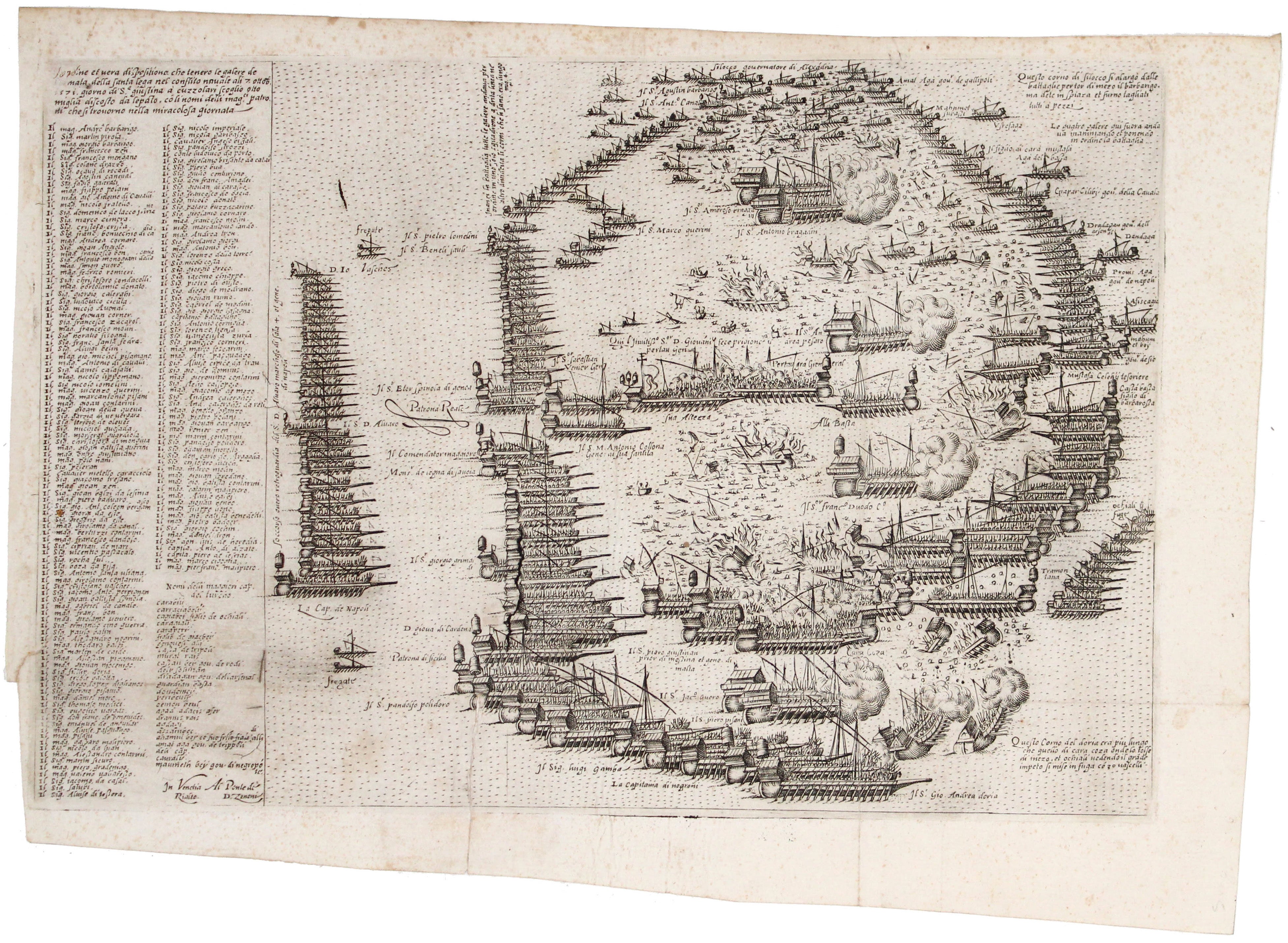
L’ordine et vera dispositione che tenero le galere de l’armata della Santa lega nel conflito navale ali 7 ottob. 1571 giorno de S.agiustina a cuzzolari scoglio otto miglia discosto da lepanto con li nomi delli mag.ri patroni che si trovorno nella miracolosa giornata
The battle of Lepanto was the largest sea battle since classical antiquity, and the last in Europe where both sides relied on galleys and galleases, the descendants of ancient triremes. Read more
Our map is an exceptionally scarce contemporary Venetian depiction of that battle, the decisive naval engagement off the coast of Greece which largely checked the Ottoman advance in the Mediterranean. Venetian and Spanish vessels were the backbone of the forces fielded by the Catholic Holy League, and their captains are listed in two columns to the left of the image, followed by a shorter list of Ottoman commanders.
Domenico Zenoi or Zenoni (fl. 1559-74) was an engraver, goldsmith and publisher active in Venice (where he worked for Nicolaus Stopius) and in Padua. On December 5th 1566 the Venetian Senate granted him a 15 year privilege for the maps, portraits and devotional prints which he intended to publish. He probably had commercial partnership agreements with Camocio and with Ferrando and Donato Bertelli.
The first town book printed in Venice was Paolo Forlani’s 'Il Primo Libro delle Citta et fortezze principali del Mondo', issued in the first part of 1567. Forlani’s publication was soon followed by another town book, complementary to the first one, without a title but with a frontispiece dated April 4th 1567 signed by Domenico Zenoi and dedicated by him to Ieronimo Lippomani, Ambassador to Archduke Charles and brother of the Emperor Maximilian II. No further editions were published.
Zenoi’s maps are dated prior to 1574 and like the larger maps of the Lafreris-style atlases, these smaller maps were first issued for loose sheet circulation and then assembled into booklet form to suit individual customers’ requirements.
Condition & Materials
Copper engraving, 31.5 x 21 cm, black and white, slight spotting, mostly in upper margin, a couple of tiny wormholes, closed split along one fold and short closed tear where tabbed into a bound volume, numbered in an old hand on blank verso; signed at lower left “In Venetia Al Ponte di Rialto D. Zenoni”. Watermark: “Letter M in a shield with star”.
References
Not in Zacharakis, and we have been unable to locate any institutional holdings. Our example was bound into a book, perhaps a composite work (see, for example, Shirley T.COM 19-a) or, conceivably, a copy of Bertelli’s 1574 edition of ‘Civitatum aliquot insigniorum’ or Camocio’s ‘Isole Famose’ of c. 1572, both of which cover the Fourth Venetian-Ottoman War and contain maps by a number of Venetian engravers, including Zenoi.
Alamgià: Monumenta Cartographica Vaticana, vol. II p. 116; Ganado: A study in depth of 143 maps representing the Great Siege of Malta of 1565, pp.303-5; Bury: The Print in Italy, p. 236. Read less