Map of London After the Great Fire
SKU: 8917Title:
Map of London After the Great Fire
Date of publication:
1756
Printed Measurement:
22.5 x 33 cm
Colour:
black and white
Mapmaker(s):
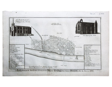
A Plan of the City and Liberties of London after the Dreadful Conflagration in the Year 1666. The Blank Part whereof represents the Ruins and Extent of the Fire; & the Perspective that left Standing.
Copper engraving, 22.5 x 33 cm, black and white, trivial spotting, blank verso.
Map of London showing the extent of the destruction caused by the Great Fire of London in 1666. It was derived from Wencelsaus Hollar’s near-contemporary version and was first published in the expanded second edition of William Maitland’s History of London. ‘Remarkable places’ and churches are identified in the keyed indices, top right and bottom left. Adams, London Illustrated, 38/007. Howgego, Printed maps of London, 19a.