

Mind The Gap! Underground mapmakers revealed...
It’s time for another crack at revealing the lives of the designers who made early Underground maps. We know so much about Harry Beck and MacDonald Gill, and so little about almost everyone else… It has been a while (longer than I thought) since I delved into the life and times of Fred Stingemore so this is long overdue. One day I hope to find a way of putting names to the teams of (currently) anonymous draughtsmen who worked ‘in house’ for the printing companies regularly commissioned by the Underground Group and its predecessors, such as Edward Stanford Ltd, WJ Adams & Sons, Waterlow & Sons, Johnston, Riddle & Co, Dangerfield Printing Co, George Philip & Son and David Allen & Sons. For now, though, let’s look at three names which we do have. These names appear on maps which are well-known but normally catalogued (by me and everyone else, including the Transport Museum) with surname and initials as given, without further elucidation: W.E. Soar; J.C. Betts; E.G. Perman. Who were they?
William Edward Soar (1854-1912) may be the earliest credited designer of Underground maps. His name appears on most maps produced by the District Railway from 1880 until his death. He was described as ‘an indefatigable member of the staff of the District Railway,


William Soar was born on 28 September 1854 and baptised on 22 October 1854 at Paddington, Middlesex. His father, John, was a coachman. At the time of his death he lived in West Hill, Putney; Putney Bridge was one of the District Line’s termini from 1880, and East Putney station (more convenient for his daily commute) was opened in 1889 (the Putney Bridge to Wimbledon extension is included as an inset on some of his maps, such as the one we’ve illustrated above). The West London Observer (3 January 1913) reported that he died suddenly at Stoke Poges on Boxing Day 1912 whilst on a visit; he was buried on 31 December at Wandsworth, aged 58.
J.C. Betts and E.G. Perman represent the other strand of Underground map-making policy: hiring established commercial artists and graphic designers such as MacDonald Gill and Hans Schleger. Jack Charles Betts (1896-1960) produced a black and white pictorial plan of the British Empire Exhibition for its second season (May-October 1925), and an elegant tube map of the central area issued in Winter 1924/5 and Summer 1925.

According to Artist Biographies, Jack Betts studied design and calligraphy at the Royal College of Art under Robert Anning Bell and Edward Johnston; excellent credentials for anyone wanting to work for the Underground Group, and one wonders if there was any overlap with the circles Gill moved in (although Gill was a dozen years his senior and had studied under Johnston at Central). Betts was one of the founder members of the Clement Dane Studio, an agency which developed a longstanding relationship with London Transport, although I can find no indication that he designed any further maps for them. In August 1925, while his map of the central area was still being given away at stations, Betts married fellow graphic artist Constance Castle (1902-1966) at Liversedge in Yorkshire, where her parents lived in Duxbury Hall. The wedding was announced in the Yorkshire Post and the Bath Chronicle (the groom’s hometown) and the honeymoon was spent in France and Italy. It all sounds pleasantly prosperous.
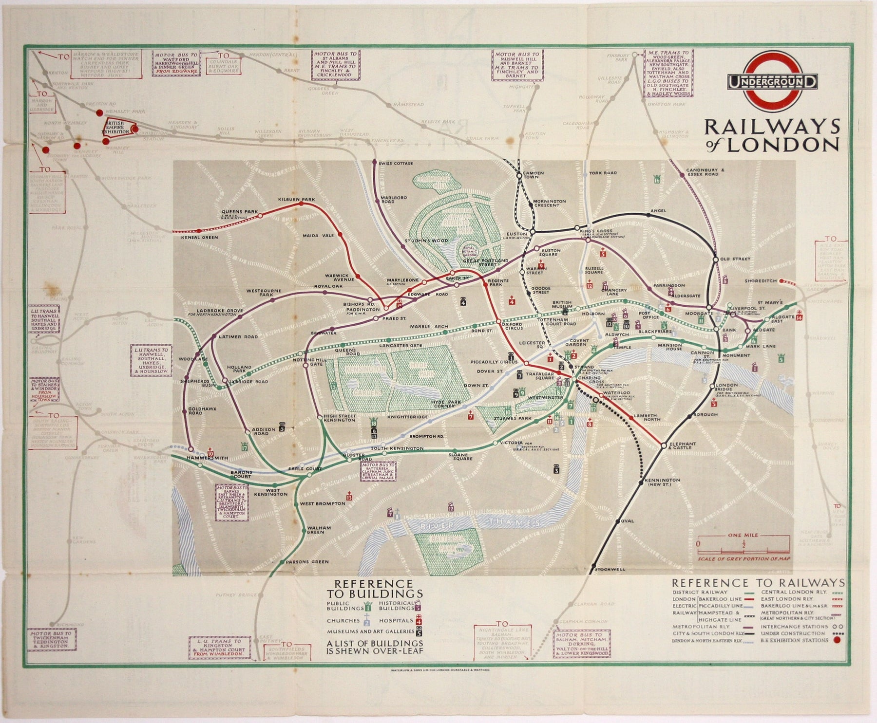
Edgar George Perman (1875-1955) designed a single, delightful, portrait format passenger map of the Underground, which was issued 1928-29.

The style of the lines, stations and interchanges follows the series of maps created by Fred Stingemore, while the calligraphy is influenced by MacDonald Gill. Perman’s map is aimed at the visitor to London: major roads, parks and other recreational spaces are shown within the context of the Underground network, and a numbered key identifies sites of historical interest, museums and galleries, churches and other public buildings. Fred Stingemore’s trifold maps were in circulation at exactly the same time, with all the surface topography stripped away. Stingemore’s maps may have been aimed at the commuter, Perman’s encourages leisure travel. In the same year he produced a double royal poster ‘All the sights of London, by Underground’, and he also designed some advertising material (possibly including ‘antique style’ route maps) for Shell. An update will be forthcoming when I spot one.
Artist Biographies notes that he was born in Ealing, died in Kew, studied at Westminster School of Art in the 1890s and was active as a commercial artist in the 1920s, but for such a competent artist he does not seem to have amassed a vast body of work. And what happened after 1929? In the 1930s the London-based firm EG Perman and Co was an energetic promoter of the ‘Flying Flea’, a light aircraft which was intended by its French inventor to become the Model T Ford of the air. If anyone can demonstrate that our EG Perman abandoned the world of fine art in his fifties to promote air travel for all (including his own version of the Flying Flea, the Perman Parasol) I shall be thrilled. It would certainly be the most exotic explanation for why there were no more maps.
Leave a comment