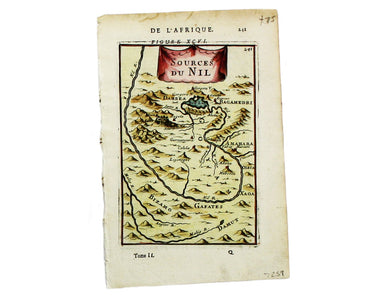
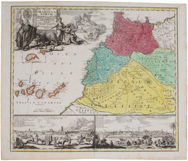
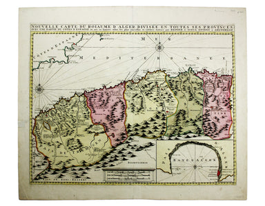
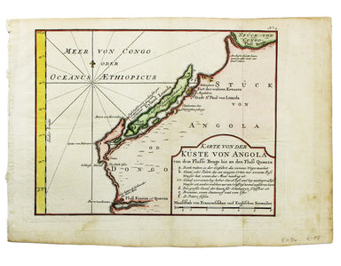
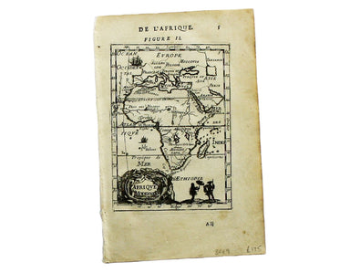
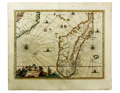
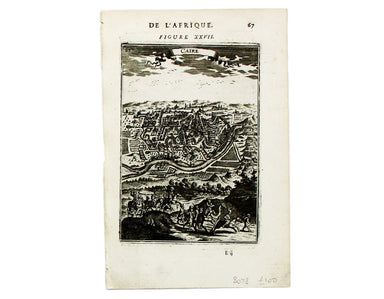
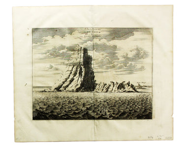
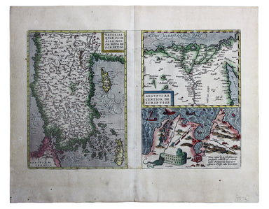

Tallis' Map of Natal
This map of Natal was engraved by John Rapkin for John Tallis' popular ‘Illustrated Atlas’; it includes vignettes of Port Natal engraved by William...
View full detailsThis map of Natal was engraved by John Rapkin for John Tallis' popular ‘Illustrated Atlas’; it includes vignettes of Port Natal engraved by William...
View full detailsExtensive areas of this map of Africa are left entirely blank, but there is also a considerable amount of speculative material. The legendary Mount...
View full detailsThis map of Africa was regularly updated to reflect the advances (and uncertainties) of European exploration, but this particular example appears t...
View full detailsThe Empire of Morocco, since 1912, had been divided between the Spanish and French. Our map dates to the period of the Rif War, 1921-26, in which a...
View full detailsThis map of South Africa was published by The Times during the Second Anglo-Boer War, for the benefit of members of the British public following th...
View full detailsCape Verde Ilands Copper engraving, 11.5 x 13.5 cm, black and white, map of Cape Verde with English text beneath and on the verso, published 'Geogr...
View full detailsThis map of Africa reflects the state of European knowledge of the interior before the mid 19th century search for the sources of the Nile. It mar...
View full detailsThis map of Western Africa shows caravan routes leading into the Sahara; the course of the Niger – still partially uncertain, but reaching a point...
View full detailsThis bird’s-eye view of the Suez Canal was published as a ‘Special Supplement’ of The Graphic (a weekly illustrated newspaper), issued on 2 Septem...
View full detailsCopper engraving, 28.5 x 25 cm, original hand-colour, blank verso, published in ‘Oddy’s New General Atlas of the World’. This map of Africa featur...
View full detailsAfrica – Southeast Coast – Port Natal Engraved British chart of Durban port, sheet size 68.5 x 105 cm, black and white, engraved by John and Charle...
View full detailsNouvelle Carte du Roiaume d’Alger […] Copper engraving, 44.5 x 56 cms, original hand-colour, blank verso; map of Algeria with an inset of the Bay o...
View full detailsOutline Map shewing Railways of Nigeria The map shows the railways of Nigeria completed and under construction. A gummed Nigerian revenue stamp has...
View full detailsPort Florence [Kisumu, Kenya] Engraved chart, 66 x 48.5 cm, black and white, first published in 1902 with corrections to 1909, crease and ink stamp...
View full detailsGuinea propria, nec non Nigritiae, vel Terrae Nigrorum maxima pars … Copper engraving, 51 x 59 cm, original hand-colour, blank verso. Detailed and ...
View full detailsNovissima et Perfectissima Africae Descriptio Copper engraving, 50 x 58 cm, original hand-colour, closed split at foot of centrefold, blank verso. ...
View full detailsKarte von der Küste von Angola von dem Flusse Bengo bis an den Fluss Quanza Copper engraving, 21.5 x 27.5 cm, modern hand-colour, tiny wormtrack in...
View full detailsIsle de Madere Copper engraving, 15 x 10.5 cm, black and white, French text on verso; Madeira, from Mallet’s Description de l’Univers, first publis...
View full detailsAlexandrie Copper engraving, 15 x 10.5 cm, black and white, French text on verso; map of Alexandria, from Mallet’s Description de l’Univers, first ...
View full detailsAegypte Copper engraving, 15.5 x 10.5 cm, black and white, trivial stain top left, French text on verso; map of ancient Egypt from Mallet’s Descrip...
View full detailsDe Stadt Cairus. Le Caire. Copper engraving, 24.5 x 32 cm, black and white, blank verso. Olfert Dapper (1636-1689) was a Dutch physician and schola...
View full detailsAfrica Lithograph, 36.5 x 50 cm, drawn and engraved by Edward Weller, insets of Mauritius, Réunion and Natal, original hand colour in outline, blan...
View full detailsAfrique Copper engraving, 14 x 10.5 cm, black and white, French text on verso; map of the continent of Africa from Mallet’s Description de l’Univer...
View full detailsInsula S. Laurentii, vulgo Madagascar. Copper engraving, 28.5 x 37 cm, modern hand colour, blank verso. Olfert Dapper (1636-1689) was a Dutch phys...
View full detailsBône Copper engraving, 14.5 x 20 cm, black and white as issued, blank verso. The practical pocket sea atlas by Marseilles hydrographer Joseph Roux,...
View full detailsRade de Mogodor Copper engraving, 14.5 x 19.5 cm, black and white as issued, blank verso. Essaouira, then Morocco’s principal port. The practical ...
View full detailsSources du Nil Copper engraving, 14.5 x 10.5 cm, recent hand-colour, French text on verso, from Mallet’s Description de l’Univers.
Tabula Aphricae II Copper engraving, 19 x 26.5 cm, Italian text on verso. Ruscelli’s map of North Africa, following Gastaldi, was first issued in h...
View full detailsAegyptus Copper engraving, 19.5 x 24.5 cm, engraved by Sidney Hall, original outline hand-colour, blank verso; from Butlerís Atlas of Ancient Geogr...
View full detailsS. Salvador Copper engraving, 15 x 10.5 cm, recent hand-colour, French text on verso, from Mallet’s Description de l’Univers. São Salvador was onc...
View full detailsDu Nil et ses Embouchures et des Crocodiles Copper engraving, 15 x 10.5 cm, recent hand-colour, French text on verso, from Mallet’s Description de...
View full detailsBiledulgerid en General Copper engraving, 15 x 10.5 cm, recent hand-colour, French text on verso, from Mallet’s Description de l’Univers.
Caire Copper engraving, 15 x 10.5 cm, black and white, French text on verso; map of Cairo derived, ultimately, from Matteo Pagano’s magnificent 21 ...
View full detailsLe Pik de Teneriffe/De Piek-Bergh op het Eilant Tenerifto Copper engraving, 24.5 x 32 cm, black and white, blank verso. Olfert Dapper (1636-1689) w...
View full detailsBengasi Copper engraving, 14.5 x 20 cm, black and white as issued, light staining bottom right, blank verso. The practical pocket sea atlas by Ma...
View full detailsCarte des Isles du Cap-Verd Copper engraved sea-chart, 48 x 33 cm, engraved by Guillaume de la Haye, black and white as issued, blank verso. D’Aprè...
View full detailsLower Egypt and the Adjacent Deserts with a part of Palestine; to which has been added the Nomenclature of the Roman Age… Copper engraving, 56 x 78...
View full detailsSouth Africa Steel engraving, 32 x 39.5 cm, engraved by John & Charles Walker, map of South Africa inset of Cape Town, original hand colour in ...
View full detailsBlatt 29. Warmbad Folding map of !Karas region of Namibia, sheet size 68 x 59.5 cm, printed in colours, dissected into 12 panels and laid on linen,...
View full detailsIndischer Ocea – Afrika, Ost Küst – Lindi-Bucht Imperial German Naval Office chart, sheet size 76.5 x 56 cm, engraved by K. Blume, black and white,...
View full detailsNatoliae quae olim Asia Minor nova descriptio / Aegypti recentior descriptio / Carthaginis celeberrimi sinus typus. Copper engraving, 32 x 49 cm, t...
View full detailsTopographia Repraesentio Barbarici Portus et Urbis Munitae Oran … Copper engraving, 49.5 x 57 cms, original hand colour to both town plan and prosp...
View full detailsFolding lithographically printed map of Anglo-Egyptian Sudan, GSGS War Offfice sheet 2692, 95 x 72 cm, dissected into 30 panels and laid on linen,...
View full details