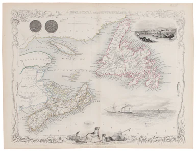
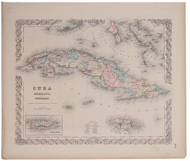
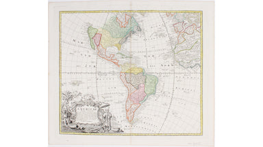
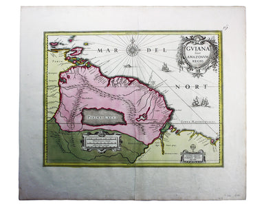
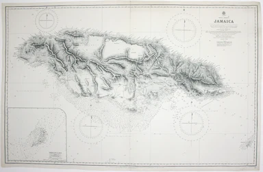
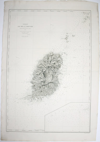
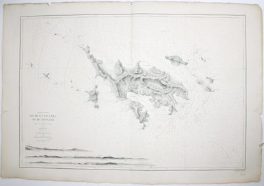
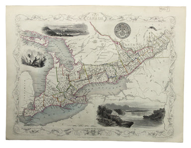
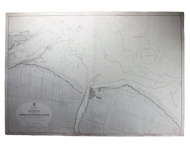
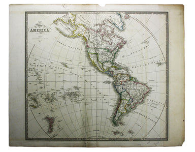
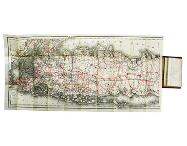
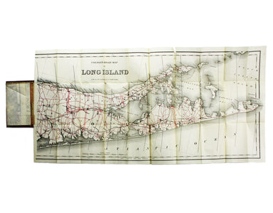
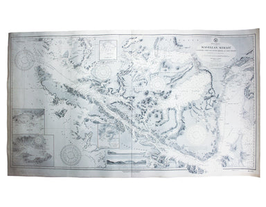
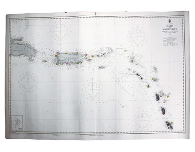
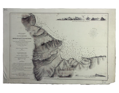

Danny Arnold's Map of the Wild West
Danny Arnold was a Canadian actor and impresario whose vaudeville and wild west shows were a feature of the British seaside from the late 1950s unt...
View full detailsDanny Arnold was a Canadian actor and impresario whose vaudeville and wild west shows were a feature of the British seaside from the late 1950s unt...
View full detailsThis map of Central America was engraved by John Rapkin for John Tallis' popular ‘Illustrated Atlas’. It includes black and white vignettes of Beli...
View full detailsThis map of Nova Scotia was engraved by John Rapkin for John Tallis' popular ‘Illustrated Atlas’; it includes black and white vignettes of Halifax,...
View full detailsThis is one of the most detailed mid-19th Century American atlas maps of Cuba and the region, set within Colton’s distinctive style of border, by o...
View full detailsThe 'Revoltas da Armada', the Brazilian naval mutinies of 1893-1894, were linked with the Federalist Rebellion against the recently-formed First Br...
View full detailsThis route map was published in a report to Congress as ‘Letter from the postmaster general transmitting a report of General Bernard, of surveys of...
View full detailsOur map of the Americas was prepared for the Homann firm by Johann Matthias Hase, professor of mathematics in Wittenberg, on his stereographic hori...
View full detailsTerra Firma et Novum Regnum Granatense et Popayan This regional map covers Colombia and neighbouring parts of present day Panama, Ecuador, Costa Ri...
View full detailsA July 1910 map of the Uptown and Downtown Hudson Tubes, pairs of tunnels connecting Jersey City with Greenwich Village in New York and with the Hu...
View full detailsThis is a late issue of Blaeu’s map of Guiana, with full-body colour typical of the later seventeenth-century. Seventeenth and eighteenth century m...
View full detailsWest Indies – Tobago – Scarborough – Rockly Bay This chart of Rockly Bay shows soundings etc, with interior detail of relief, roads and settlements...
View full detailsThis chart of Jamaica shows soundings etc, with interior detail of relief, roads and settlements, and an inset of Morant Cays. First published in 1...
View full detailsAntilles – Ile de la Grenade This detailed chart of Grenada was derived from British Admiralty surveys. Condition & Materials French naval char...
View full detailsAntilles – Ile de Culebra ou du Passage This detailed chart of Isla Culebra (now an island-municipality of Puerto Rico) was derived from British Ad...
View full detailsA Chart of the Atlantic Ocean, exhibiting the seat of war both in Europe and America according to the latest discoveries and regulated by Astronomi...
View full detailsL’Amerique Meridionale qui fait l’autre partie des Indes Occidentales This map of South America features figures in indigenous costume and a vignet...
View full detailsThis map of Peru and Bolivia was engraved by John Rapkin for the ‘Illustrated Atlas’. It has vignettes including a view of Potosi engraved by James...
View full detailsThis map of East Canada and New Brunswick was engraved by John Rapkin for the ‘Illustrated Atlas’, published serially from the mid 1840s onwards an...
View full detailsThis map of West Canada was engraved by John Rapkin for the ‘Illustrated Atlas’. The map also includes black and white vignettes of Kingston, Ontar...
View full detailsSouth America – British Guiana – Georgetown and mouths of Demerara and Essequibo Rivers This British chart of Georgetown shows soundings etc, with ...
View full detailsThe Falkland Islands, surveyed by Captains Robert Fitz Roy R.N., William Robinson R.N. and Bartholomew James Sulivan R.N. This map of the Falkland...
View full detailsCarte générale des découvertes de l’Amiral de Fonte, representant le grande probabilité d’un Passage au Nord Ouest Maps depicting the purported voy...
View full detailsThis distinctive map of California as an island is from Mallet’s Description de l’Univers, first published in Paris in 1683 and reprinted with Germ...
View full detailsAntilles – Ile Sainte Croix This detailed chart of Saint Croix in the US Virgin Islands (then the Danish West Indies) was derived from a British Ad...
View full detailsWest Indies – Santa Cruz [Saint Croix] This chart of Saint Croix shows soundings etc, with interior detail of relief, roads and settlements, coasta...
View full detailsThis map of America is from Wyld's New General Atlas. James Wyld senior established a highly successful firm of map publishers, which passed to his...
View full detailsCondition & Materials Lithographed in red and black on two sheets, each 38.5 x 80 cm; this map of Long Island is printed on thin india paper; ...
View full detailsNouvelle Carte des Decouvertes faites par des Vaisseaux Russiens aux Cótes Inconnues de l’Amerique Septentrionale avec les Pars Adjacents […] a St....
View full detailsKarte von der Insel St Lucia This map of the Caribbean island of St Lucia was published in the Dutch edition of Prévost's Histoire Générale des Voy...
View full detailsThis pictorial map of Panama is US military mailer, designed to be folded and posted home. The verso has a detailed map of the canal zone, with sta...
View full detailsCarte des Isles de Cuba et de la Jamaique This map of Cuba and Jamaica was published in Grenet’s 'Atlas Portatif a l'Usage des Colleges, pour Servi...
View full detailsSouth America – Magellan Strait – Western part from Punta Arenas to Cape Pillar This US naval chart of the Magellan Strait shows soundings, anchora...
View full detailsWest Indien – Haïti bis Martinique This Imperial German Naval Office chart shows sands, soundings and interior detail of relief. Condition & Ma...
View full detailsOcéan Pacifique – Ile Juan Fernandez – Mouillage de San Juan Bautista This French naval chart shows the anchorage at San Juan Bautista located on C...
View full detailsWest Indies – St Croix Island – Christiansted Harbour This is a US naval chart of Christiansted, the largest town on St Croix in the United States ...
View full detailsThis map of Dominica is from 'The Gentleman's Magazine'. It was published after the French recaptured the island during the Anglo-French War of 177...
View full detailsPreliminary Chart – West Indies – Barbados This chart of Barbados shows sands and soundings etc, with interior detail of relief, roads and settleme...
View full detailsMappa Geographica, complectens I. Indiae Occidentalis Partem Mediam Circum Isthmum Panamensem […] Carte des Isles de L’Amerique et Deplusieurs Pays...
View full details