

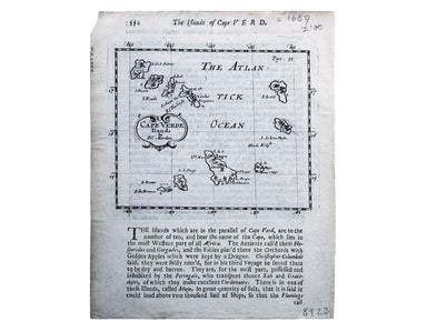
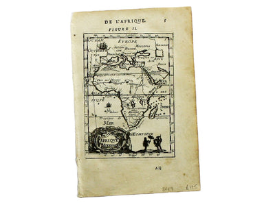
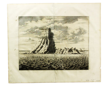
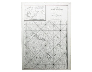
Morden’s Map of the Cape Verde Islands
Cape Verde Ilands Copper engraving, 11.5 x 13.5 cm, black and white, map of Cape Verde with English text beneath and on the verso, published 'Geogr...
View full detailsCape Verde Ilands Copper engraving, 11.5 x 13.5 cm, black and white, map of Cape Verde with English text beneath and on the verso, published 'Geogr...
View full detailsAfrica – Southeast Coast – Port Natal Engraved British chart of Durban port, sheet size 68.5 x 105 cm, black and white, engraved by John and Charle...
View full detailsPort Florence [Kisumu, Kenya] Engraved chart, 66 x 48.5 cm, black and white, first published in 1902 with corrections to 1909, crease and ink stamp...
View full detailsIsle de Madere Copper engraving, 15 x 10.5 cm, black and white, French text on verso; Madeira, from Mallet’s Description de l’Univers, first publis...
View full detailsAlexandrie Copper engraving, 15 x 10.5 cm, black and white, French text on verso; map of Alexandria, from Mallet’s Description de l’Univers, first ...
View full detailsAegypte Copper engraving, 15.5 x 10.5 cm, black and white, trivial stain top left, French text on verso; map of ancient Egypt from Mallet’s Descrip...
View full detailsDe Stadt Cairus. Le Caire. Copper engraving, 24.5 x 32 cm, black and white, blank verso. Olfert Dapper (1636-1689) was a Dutch physician and schola...
View full detailsAfrique Copper engraving, 14 x 10.5 cm, black and white, French text on verso; map of the continent of Africa from Mallet’s Description de l’Univer...
View full detailsBône Copper engraving, 14.5 x 20 cm, black and white as issued, blank verso. The practical pocket sea atlas by Marseilles hydrographer Joseph Roux,...
View full detailsRade de Mogodor Copper engraving, 14.5 x 19.5 cm, black and white as issued, blank verso. Essaouira, then Morocco’s principal port. The practical ...
View full detailsTabula Aphricae II Copper engraving, 19 x 26.5 cm, Italian text on verso. Ruscelli’s map of North Africa, following Gastaldi, was first issued in h...
View full detailsCaire Copper engraving, 15 x 10.5 cm, black and white, French text on verso; map of Cairo derived, ultimately, from Matteo Pagano’s magnificent 21 ...
View full detailsLe Pik de Teneriffe/De Piek-Bergh op het Eilant Tenerifto Copper engraving, 24.5 x 32 cm, black and white, blank verso. Olfert Dapper (1636-1689) w...
View full detailsBengasi Copper engraving, 14.5 x 20 cm, black and white as issued, light staining bottom right, blank verso. The practical pocket sea atlas by Ma...
View full detailsCarte des Isles du Cap-Verd Copper engraved sea-chart, 48 x 33 cm, engraved by Guillaume de la Haye, black and white as issued, blank verso. D’Aprè...
View full detailsIndischer Ocea – Afrika, Ost Küst – Lindi-Bucht Imperial German Naval Office chart, sheet size 76.5 x 56 cm, engraved by K. Blume, black and white,...
View full details