


What was Blaeu trying to say?
I’ve just been contemplating one of Willem Blaeu’s more striking cartouches, which adorns the map of the Turkish Empire which he engraved in the 1630’s. It was copied directly by cartographers including Merian, and clearly influenced others such as de Wit. But what message was he attempting to convey? This example, with original hand-colour, was printed in Amsterdam by his sons Cornelis and Joannes in 1640, a couple of years after his death:

Here’s a detail of the cartouche itself:
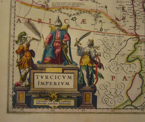
Most descriptions of the map which I have read make vague references to a depiction of the Ottoman Sultan enthroned between ‘two allegorical figures’ or even ‘servants’. Allegorical they most certainly are (both clad in loosely classical garments), but I suspect they are menacing the Sultan rather than serving him. The motto at the foot of the plinth is a Latin proverb derived from Sallust: ‘small states flourish through unity; the greatest are torn apart by discord’. It would have held particular relevance for a Dutch cartographer as the first part of the phrase was adopted by the Dutch Republic, and it was minted on the coinage Blaeu would have handled on a daily basis. Blaeu may be suggesting that the patchwork of small states visible in the upper left hand corner of the map will eventually triumph over the Ottoman Empire, although in this period, despite occasional military reverses, the Empire remained an expansionist power. In this light the allegorical figures may represent discord and harmony: the fruits of ‘war’ (or possibly internal strife, who is dressed as a typical Renaissance Roman), and a distinctly Amazonian ‘unity’, triumphantly brandishing a scimitar. The Sultan’s pose is regal, but ‘war’s’ inverted torch suggests the end of empire, and ‘unity’s’ scimitar is dangerously close to the Sultan’s ear.
Edited to add (03/13): I thought it might be worth contrasting Blaeu’s Turkish Empire cartouche with the one he prepared for his map of Persia:

Same cartographer, same period and covering a neighbouring region, but an entirely different approach. The central figure is generally thought to be Shah Abbas the Great (see, for example, Cyrus Alai in General Maps of Persia, Brill 2010). He is richly attired and flanked by two of his guards - protected, rather than threatened. The decorative elements on most early modern European maps of Persia also accentuate the positive, with images emphasising the wealth, power, scientific knowledge and trading potential of the Persian Empire. Maps of Persia also show a greater density of place-names than any other Asian country mapped in this period. Trade is the key. Persia was the most accessible Islamic country, a possible gateway to the riches of the East, which shared a common enmity with the Ottoman Turks with the European ambassadors, adventurers and merchants who ventured there in the late sixteenth and seventeenth centuries.
Leave a comment