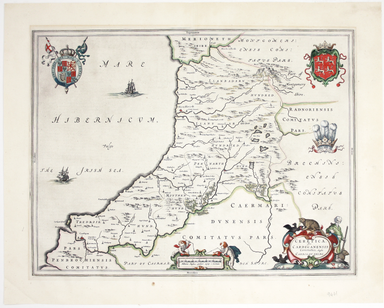
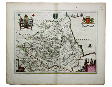
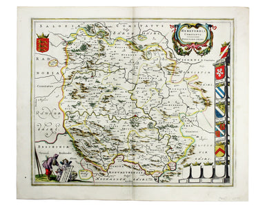
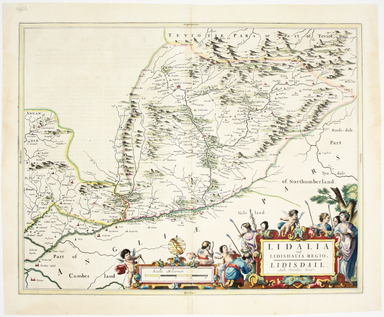
Blaeu’s Map of Cardiganshire
Ceretica sive Cardiganensis Comitatus; Anglis Cardigan Shire Blaeu and the rival Golden Age Dutch cartographic publishing house of Janssonius raced...
View full detailsCeretica sive Cardiganensis Comitatus; Anglis Cardigan Shire Blaeu and the rival Golden Age Dutch cartographic publishing house of Janssonius raced...
View full detailsThis map of the French island of Corsica, ruled by the Genoese in the 17th century and included in the Italian volume of Blaeu’s atlas, is oriented...
View full detailsBlaeu and the rival Golden Age Dutch cartographic publishing house of Janssonius raced to bring out atlases of the British Isles in the 1630s and e...
View full detailsThis is the Tuscan island of Elba, a map newly added to the ‘Atlas Novus’ in 1640. Koeman records that it was first published in the French text ed...
View full detailsBlaeu’s map of Herefordshire. Blaeu and the rival Golden Age Dutch cartographic publishing house of Janssonius raced to bring out atlases of the Br...
View full detailsThis map of Liddesdale, in the Scottish borders, is from Golden Age Dutch cartographer Blaeu’s Scottish atlas. First published in 1654, the atlas w...
View full detailsThis map of Monmouthshire and the Severn Estuary is from ‘the rarest edition of Blaeu’s Large Atlases’: only ten of the proposed eleven volumes wer...
View full detailsThis is a map of the Italian island of Sardinia, oriented with north to the left of the map. Condition & Materials Copper engraving, sheet size...
View full details[Title page: Atlas Novus, volume IV] This is an architectural title page, engraved for the fourth volume of Blaeu’s Atlas Novus. The central panel ...
View full details