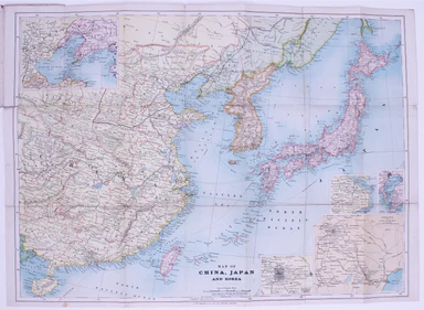
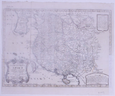
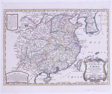
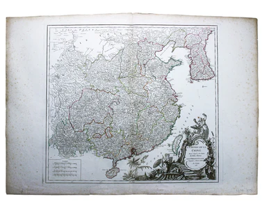
The First Atlas of the Far East published in Europe
This, the sixth volume of Blaeu’s great ‘Theatrum Orbis Terrarum’or ‘Novus Atlas’ is also the first atlas of China published in Europe. More proper...
View full details
This, the sixth volume of Blaeu’s great ‘Theatrum Orbis Terrarum’or ‘Novus Atlas’ is also the first atlas of China published in Europe. More proper...
View full details
Map of China, Japan and Korea. / [Cover title:] The Eastern Crisis. Bacon's large-scale map of Japan, Korea, China, Manchuria Produced to illustrat...
View full details
Chine du nord - Corée - Manchoukouo Manchukuo – a Japanese term for Manchuria – was a puppet state of the Empire of Japan in China and Inner Mongol...
View full details
L’Empire du Chine pour servir a l’Histoire Universelle, d’une Societe de Gens de Lettres Our example of Bellin’s map of China, with text in French ...
View full details
The Daily Mail Special Map Of The Far East Produced to illustrate the Russo-Japanese War, this map indicates Treaty Ports, dockyards and naval base...
View full details
L’Empire de la Chine dressé d’apres les Cartes de l’Atlas Chinois This detailed and relatively accurate map of China, Korea and Taiwan was derived ...
View full details
China – East Coast – Province of Shan Tung – Kyau Chau Bay This is a British chart of Jiaozhou Bay on the southern coast of the Shandong Peninsula....
View full details