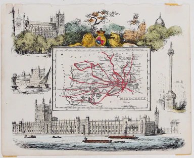
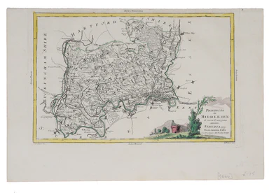
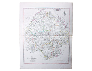
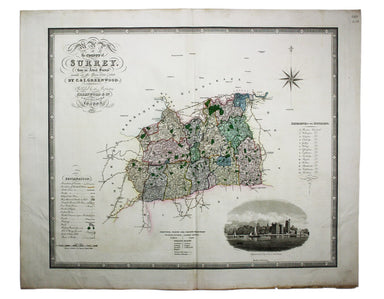
Braun & Hogenberg's Map of Cambridge
Cantebrigia, opulentissimi Anglie Regni, urbs celeberrimi nominis, ab Academie conditore Cantabro, cognominata: a Granta, fluvio vicino, Cairgrant;...
View full details
Cantebrigia, opulentissimi Anglie Regni, urbs celeberrimi nominis, ab Academie conditore Cantabro, cognominata: a Granta, fluvio vicino, Cairgrant;...
View full details
This map of Dublin was engraved by Edmund Turrell after William Barnard Clarke for The Society for the Diffusion of Useful Knowledge. The SDUK was ...
View full details
Smith's New Map of England and Wales, with part of Scotland including the turnpike and principal cross roads, the course of the rivers and navigabl...
View full details
Course of the River Mole. From Box Hill Bridge to Leatherhead shewing the situation of the various apertures called Swallows This map charting the ...
View full details
Blaeu and the rival Golden Age Dutch cartographic publishing house of Janssonius raced to bring out atlases of the British Isles in the 1630s and e...
View full details
Britannia sits in the central panel of this cartographic board game, contemplating possibilities for commerce and the arts opened up by the new rai...
View full details
Huntington, both shire and shire towne with the ancient citie Ely described This is an unusual example of John Speed’s map of Huntingdonshire – it ...
View full details
This is the index map and key to the Ordnance Survey sheets covering the entire county Tyrone on a scale of six inches to the mile. Condition &...
View full details
This is the index map and key to the Ordnance Survey sheets covering the entire county Armagh on a scale of six inches to the mile Condition & ...
View full details
This is a separately issued example of a map of Ireland which also appeared in Arrowsmith’s major work, his influential ‘London Atlas of Universal ...
View full details
This map of the environs of Edinburgh was published a decade before Ainslie’s landmark nine sheet map of Scotland. Originally published in 1778, th...
View full details
Map of the River Thames, shewing locks, bridges, adjacent roads & railways, drawn expressly for the Rowing Almanack & Oarsman’s Companion T...
View full details
This pictorial route map of the Devon General by an anonymous draughtsman for the principal bus operator in south Devon makes playful references to...
View full details
This anthropomorphic map of Ireland was published in “Geographical Fun: Being Humorous Outlines of Various Countries”. Though credited on the title...
View full details
This anthropomorphic map depicting Wales as "Owen Glendowr, in Bardic grandeur" is from 'Geographical Fun: Being Humorous Outlines of Various Count...
View full details
The cartouche on this map of the British isles is surmounted by the old Stuart coat of arms and the borders are made up of sixteen regional armoria...
View full details
This map of Middlesex was published in Reuben Ramble's ‘Travels through the Counties of England’, an uncommon county atlas for children. Reuben Ram...
View full details
This map of Middlesex was engraved by Giuliano Zuliano after Giovanni Pitteri and published in Antonia Zatta's ‘Atlante Novissimo’. This was his ...
View full details
The Railway Clearing House allocated revenue on occasions where one company’s train ran over another’s track, and promoted standardisation (of ever...
View full details
This plan of the Manchester Shipping Canal was published as a supplement to ‘The Illustrated London News’, February 3rd 1883. Construction began in...
View full details
New Road Map of England & Wales... shewing all the lines of railway, canals &c., describing the picturesque scenery and forming a complete ...
View full details
This pictorial plan of central Oxford was printed for the recently nationalised British Railways (Western Region). The arms of the University and t...
View full details
This characteristically clear and elegant map of Herefordshire is by John Cary, one of the leading cartographic engravers, publishers and globe-mak...
View full details
Do you prefer your flatfish with eyes to the right, or to the left? This map was published in the ‘Piscatorial Atlas of the North Sea, English and ...
View full details
The fish with a face only a mother could love This map was published in the ‘Piscatorial Atlas of the North Sea, English and George’s Channels’, a ...
View full details
Meunière your skate wings, or get someone else to do it for you This map was published in the ‘Piscatorial Atlas of the North Sea, English and Geor...
View full details
Why is it proverbially assumed to be very easy to run a whelk stall? They look like hard work to me This map was published in the ‘Piscatorial Atla...
View full details
For a rainy day supper, put crab in your macaroni cheese. Trust me, you’ll love it This map was published in the ‘Piscatorial Atlas of the North Se...
View full details
They’re bonnie fish and halesome farin’ This map was published in the ‘Piscatorial Atlas of the North Sea, English and George’s Channels’, a series...
View full details
Try Scotch Woodock, per The Ritz London Book of Afternoon Tea. For a pared-down version, simply spread hot buttered toast with Gentleman’s Relish a...
View full details
Waiter, bring me shad roe... This map was published in the ‘Piscatorial Atlas of the North Sea, English and George’s Channels’, a series of 50 lavi...
View full details
Pilchards are either sardines, herring, or neither. I think it depends where you (and they) are from. This map was published in the ‘Piscatorial At...
View full details
The Piscatorial Atlas was the product of a decade or more of reports and correspondence with British fishermen This map was published in the ‘Pisca...
View full details
This map was published in the ‘Piscatorial Atlas of the North Sea, English and George’s Channels’, a series of 50 lavishly chromolithographed chart...
View full details
See the east coast Fishwife with her creel This map was published in the ‘Piscatorial Atlas of the North Sea, English and George’s Channels’, a ser...
View full details
O Oysters, come and walk with us! This map was published in the ‘Piscatorial Atlas of the North Sea, English and George’s Channels’, a series of 50...
View full details
John Thomson's maps, like this one of the Channel, are characteristic of the Edinburgh school of cartography. It flourished at the beginning of the...
View full details
Map of the Grand Junction Railway and its Adjacent Country. [Copied by permission from the Company’s official map.] Shewing all the the stations on...
View full details
This map of Liddesdale, in the Scottish borders, is from Golden Age Dutch cartographer Blaeu’s Scottish atlas. First published in 1654, the atlas w...
View full details
A New Geographical Pastime: Walker’s Tour through England and Wales Most games of this nature were educational, and in this case players learn as t...
View full details
G. Bradshaw’s Map of Canals, Navigable Rivers, Rail Roads etc. in the Southern Counties of England. From actual survey shewing heights of the ponds...
View full details
This pictorial map of Liverpool is folded into a souvenir record-sleeve style pack which comprises: ‘Nothing to get hung up about’, a 30 page shor...
View full details
A New Geographical Pastime The elder John Wallis (c. 1745-1818) recovered from bankruptcy to become one of the major publishers of children’s games...
View full details
Blaeu and the rival Golden Age Dutch cartographic publishing house of Janssonius raced to bring out atlases of the British Isles in the 1630s and e...
View full details
Map of the Great Western Railway and Connections This map illustrates how the Great Western Railway connected resources such as coal fields, china ...
View full details
This pictorial map grouping the three counties northeast of London was published by British Railways (Eastern Region) to promote leisure travel jus...
View full details
This map of Middlesex was engraved by Toms for Thomas Badeslade’s ‘Chorographia Britanniae’, an attractive pocket atlas which according to Badeslad...
View full details
La VIII Table d’Angleterre/Anglesey, Wight, Vectis olim, Garnsey, Iarsay Islands around the British coast were often grouped, in various combinatio...
View full details