

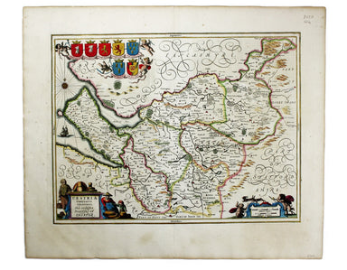
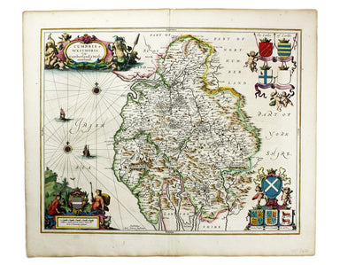
Janssonius’ Map of Cheshire
Cestria Comitatus Palatinatus. The Countye Palatine of Chester. Copper engraving, 38.5 x 50 cm, recent hand-colour, French text on verso; map of Ch...
View full detailsCestria Comitatus Palatinatus. The Countye Palatine of Chester. Copper engraving, 38.5 x 50 cm, recent hand-colour, French text on verso; map of Ch...
View full detailsProvincia Connachtiae. The Province of Connaught. Copper engraving, 38.5 x 49.5 cm, recent hand-colour, 0.5 cm diameter hole in the scale, repaired...
View full detailsCumbria & Westmoria. Vulgo Cumberland & Westmorland. Copper engraving, 42.5 x 54 cm, recent hand-colour, French text on verso. Map of Cumbr...
View full detailsComitatus Dorcestria vulgo Anglice Dorsetshire Copper engraving, 38 x 49.5 cm, recent hand-colour, French text on verso; map of Dorset Joannes Jans...
View full detailsHerefordia Comitatus vernacule Herefordshire Copper engraving, 38.5 x 50 cm, recent hand-colour, French text on verso. Map of Herefordshire. Joanne...
View full detailsLincolnia Comitatus Anglis Lyncolneshire Copper engraving, 38.5 x 50 cm, recent hand-colour, French text on verso; map of Lincolnshire Joannes Jans...
View full detailsSalopiensis Comitatus cum Staffordiensi. Shropshire & Staffordshire Copper engraving, 42.5 x 53 cm, modern hand-colour, French text on verso. M...
View full detailsInsularum Britannicarum Accurata Delineatio ex Geographicis Conatibus Abrahami Ortelii. Copper engraving, 39.5 x 51 cm, recent hand-colour, slight ...
View full details