£75.00


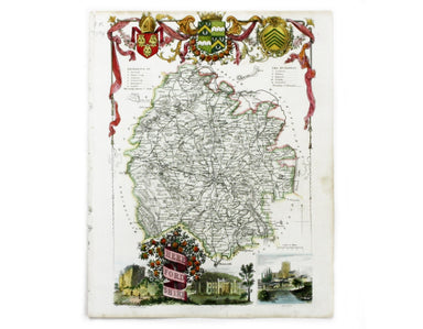
Moule’s Map of Herefordshire
Herefordshire Steel engraving, 27 x 19 cm, modern hand-colour, upper part of image fractionally trimmed, blank verso. A map of Herefordshire by Mo...
View full detailsHerefordshire Steel engraving, 27 x 19 cm, modern hand-colour, upper part of image fractionally trimmed, blank verso. A map of Herefordshire by Mo...
View full detailsGeneva (Genève) The Society for the Diffusion of Useful Knowledge was founded in 1826 with the high-minded aim of making 'useful' information avail...
View full detailsParma Steel engraving, 33 x 38 cm, original hand colour, with black and white panoramic view of Parma at the foot, blank verso. The Society for the...
View full detailsToulon Steel engraving, 33 x 40 cm; a map of Toulon engraved by B.R. Davies after W.B. Clarke, original hand colour, blank verso.
Plan du Dock ou du Bassin ‡ flot ‡ Londres dit Katarinen Dock ou Dock St. Katharine. Lithograph, 35 x 40.5 cm, black and white, blank verso; detail...
View full details