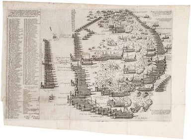
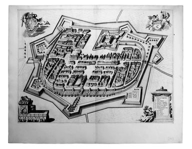
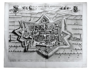
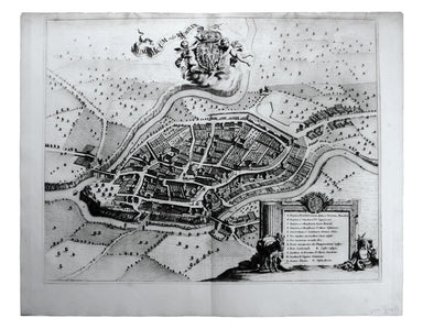
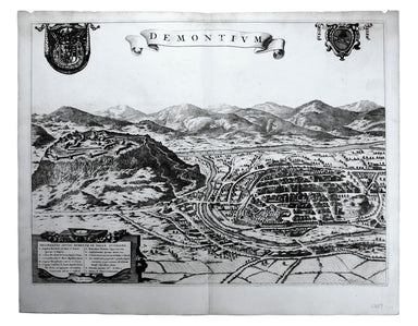
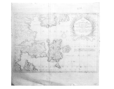
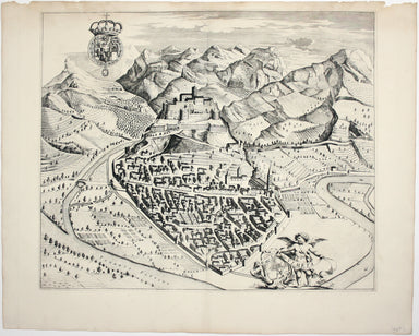
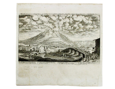
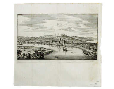
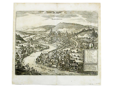
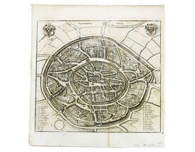
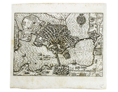
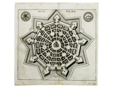
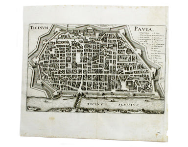
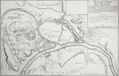
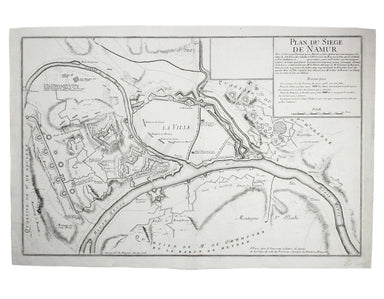
Rapin's Map of Port Mahon
This plan of the town and harbour of Mahon, St. Philip’s Castle, and its fortifications was engraved by Isaac Basire and published in Nicholas Tind...
View full details
This plan of the town and harbour of Mahon, St. Philip’s Castle, and its fortifications was engraved by Isaac Basire and published in Nicholas Tind...
View full details
Celeberrima urbs Venetiae This bird's eye plan of the city of Venice and the larger islands is a revised and anonymous version of the Merian plan. ...
View full details
This is one of the earliest obtainable views of Venice, derived from a larger woodcut by Dutch artist Erhard Reuwich, which was published in the fi...
View full details
This is one of the earliest obtainable views of Florence, derived from a lost engraving by Francesco Rosselli. The woodcuts were created in the wor...
View full details
L’ordine et vera dispositione che tenero le galere de l’armata della Santa lega nel conflito navale ali 7 ottob. 1571 giorno de S.agiustina a cuzzo...
View full details
Plan Des Antiquitez De Rome, Représentées Et Distinguées Suivant La Situation De Chacun De Ses Anciens Monuments / Roma Vetus This map of Rome is a...
View full details
Condition & Materials Circular folding map of the environs of Paris, 79 x 79 cm, engraved by Barrière (Pére) after Bariolle, black and white, d...
View full details
This map of the province of Groningen in the Netherlands, set within an elaborate strapwork border, was published in the ‘Atlas Minor’. A new serie...
View full details
Carmagnola, just south of Turin in Piedmont, was fought over and extensively remodelled in the mid seventeenth-century; it was briefly recaptured b...
View full details
Exigua & celeberrima Verruca […] This is a map of Verrua Savoia, north east of Turin in Piedmont. Blaeu’s townbook of Savoy and Piedmont was fi...
View full details
Villa Nova dell’ Astegiana This is a map of Villanova d’Asti, in Piedmont. Blaeu’s townbook of Savoy and Piedmont was first published by the Blaeu ...
View full details
Fons Herculeus: Cum Suis Colosso, Cryptoporticu, Antris, Sacellis, Scalis, Dioetis, Tricliniis, Statuis, Signis, Tabulis, Coeterisque Musivis, ac m...
View full details
Rumiliacum vulgo Rumilly Blaeu’s townbook of Savoy and Piedmont was first published by the Blaeu heirs in 1682, but the plates were purchased and r...
View full details
Moustiers Blaeu’s townbook of Savoy and Piedmont was first published by the Blaeu heirs in 1682, but the plates were purchased and reissued (with B...
View full details
This map of Demonte in Piedmont was engraved by Juvenal Boetto. Blaeu’s townbook of Savoy and Piedmont was first published by the Blaeu heirs in 16...
View full details
Camberium / Chambery Blaeu’s townbook of Savoy and Piedmont was first published by the Blaeu heirs in 1682, but the plates were purchased and reiss...
View full details
Famosae in. Archipelago, Chius hodie Scio Insulae, victricibus nuper Venetorum classe et armis Turcarum imperio ereptae, nec non aliarum adjacentiu...
View full details
This miniature map of the Low Countries was published in the first edition of Tabularum geographicarum contractarum libri, a geographical work whic...
View full details
This map of Sicily is from the second series of maps engraved by Philip Galle for the Epitome, the pocket atlas version of Ortelius’ Theatrum. Cond...
View full details
Typus Regni Neapolitani This map of the Kingdom of Naples is from the second series of maps engraved by Philip Galle for the Epitome, the pocket at...
View full details
Camaldulensium, nondum omnino absoluta ad Lancei oppidum eremus This is the Camaldolese hermitage near Lanzo Torinese in Piedmont (which is visible...
View full details
This is a map of Revello, near Cuneo in Piedmont. Blaeu’s townbook of Savoy and Piedmont was first published by the Blaeu heirs in 1682, but the pl...
View full details
This is a map of Ormea, near Cuneo in Piedmont. Blaeu’s townbook of Savoy and Piedmont was first published by the Blaeu heirs in 1682, but the plat...
View full details
Cartusia Vallis Pisii, fundata 1173 This is the Charterhouse of Pesio, a Carthusian foundation near Cuneo in Piedmont. Blaeu’s townbook of Savoy an...
View full details
This map shows the ‘Germanic’ regions of Europe, including the Low Countries, Poland and Austria, and was engraved by Jodocus Hondius for the ‘Atla...
View full details
Britannia et Normandia cum consiniis This map of Brittany and Normandy was engraved by Jodocus Hondius for the ‘Atlas Minor’. Condition & Mater...
View full details
This view shows the major eruption of Vesuvius in December 1631, published by Merian and his heirs in various works, including the Itinerarium Ital...
View full details
This is a view of the Solfatara volcanic crater, mythological home of Vulcan in the Phlegraean Fields at Pozzuoli, near Naples. It was published by...
View full details
This plan of of Ostia was published by Merian and his heirs in various works, including the Itinerarium Italiae of 1640, the Archontologia cosmica ...
View full details
This plan of Piacenza was published by Merian and his heirs in various works, including the Itinerarium Italiae of 1640, the Archontologia cosmica ...
View full details
This map of Baden in Switzerland was published by Merian and his heirs in various works, including the Archontologia cosmica, Theatrum Europaeum an...
View full details
This map of Stade was published by Merian and his heirs in various works, including the Theatrum Europaeum. Condition & Materials Copper engrav...
View full details
This map of Wismar was published by Merian and his heirs in various works, including the Theatrum Europaeum. Condition & Materials Copper engr...
View full details
This map of Aachen, or Aix-la-Chapelle, was published by Merian and his heirs in various works, including the Theatrum Europaeum. Condition & M...
View full details
This plan of Mantua was published by Merian and his heirs in various works, including the Itinerarium Italiae of 1640 and editions of the Theatrum ...
View full details
This plan of Genoa was published by Merian and his heirs in various works, including the Itinerarium Italiae of 1640 and editions of the Theatrum E...
View full details
This plan of Palmanova (a Venetian town founded in 1593, sheltered behind innovative fortifications taking the form of a nine-pointed star) was pub...
View full details
This plan of Loreto (site of the Basilica della Santa Casa) was published by Merian and his heirs in various works, including the Itinerarium Itali...
View full details
This plan of Pavia (the ancient Ticinum) was published by Merian and his heirs in various works, including the Itinerarium Italiae of 1640 and edit...
View full details
This plan of Naples was published by Merian and his heirs in various works, including the Itinerarium Italiae of 1640 and editions of the Theatrum ...
View full details
This plan of Messina was published by Merian and his heirs in various works, including the Itinerarium Italiae of 1640 and editions of the Theatrum...
View full details
This map of Bremen was published by Merian and his heirs in various works, including the Theatrum Europaeum. Condition & Materials Copper engra...
View full details
This map of Rostock was published by Merian and his heirs in various works, including the Theatrum Europaeum. Condition & Materials Copper eng...
View full details
This plan of Florence was published by Merian and his heirs in various works, including the Itinerarium Italiae of 1640 and editions of the Theatru...
View full details
Plan du Siege de Namur avec les nouveaux travaux que sa Majesté y a fait adjouter qui sont marquees à la lettre A. Cette place fut reduitte à l’obb...
View full details
Pomeraniae Wandalicae Regionis Typ. [on sheet with] Livoniae Nova descriptio [and] Ducatus Oswieczensis et Zatoriensis Descriptio An early example ...
View full details
Parte Occidentale/Orientale del Governo Generale d’Orleans This map of the Duchy of Orleans is from Mercurio Geografico, an unusual and finely engr...
View full details
Governo Generale dell’Isola Di Francia (Île-de-France) This map of Île-de-France is from Mercurio Geografico, an unusual and finely engraved work. ...
View full details