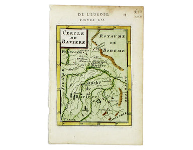
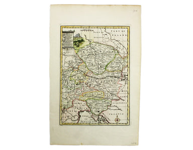
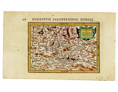
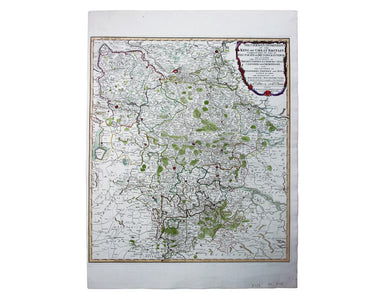
Mallet’s Map of Hungary
This map of Hungary is from Mallet’s Description de l’Univers. Condition & Materials Copper engraving, 15 x 11.5 cm, recent hand-colour, Frenc...
View full details
This map of Hungary is from Mallet’s Description de l’Univers. Condition & Materials Copper engraving, 15 x 11.5 cm, recent hand-colour, Frenc...
View full details
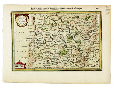
Cercle de Baverie This map of Bavaria is from Mallet’s Description de l’Univers. Condition & Materials Copper engraving, 15 x 11.5 cm, recent h...
View full details
This map of the Netherlands is from Mallet’s Description de l’Univers. Condition & Materials Copper engraving, 15 x 10 cm, recent hand-colour, ...
View full details
Les 13 Cantons Suisses et leurs Alliez This map of 13 Swiss Canton is from Mallet’s Description de l’Univers. Condition & Materials Copper engr...
View full details
Here's King Christian V, as he appears in Mallet’s ‘Description de l’Univers. Condition & Materials Copper engraving, 15 x 10.5 cm, recent han...
View full details
Here are some lovely Swedes, from from Mallet’s ‘Description de l’Univers. Condition & Materials Copper engraving, 15 x 10.5 cm, recent hand-co...
View full details
France/Paîs Bas This map of France and the Low Countries is from Mallet’s ‘Description de l’Univers. Condition & Materials Copper engraving, 15...
View full details
This map of France is from Mallet’s Description de l’Univers. Condition & Materials Copper engraving, 15 x 10.5 cm, recent hand-colour, light ...
View full details
Condition & Materials Copper engraving, 23 x 32.5 cm, recent hand-colour, blank verso.
Condition & Materials Copper engraving, 9.5 x 13.4 cm, recent hand-colour, Latin text on verso; miniature map of Artois.
Condition & Materials Copper engraving, 9.5 x 13.4 cm, recent hand-colour, Latin text on verso; map of the Zijpe polder.
Veromandui This map of the modern Aisne is named here for the Viromandui, a Belgic tribal name. Condition & Materials Copper engraving, 9.5 x 1...
View full details
Condition & Materials Copper engraving, 9.5 x 13.4 cm, recent hand-colour, Latin text on verso; map of Hainault.
Condition & Materials Copper engraving, 9.5 x 13.4 cm, recent hand-colour, Latin text on verso; map of Liège.
A miniature map of Salzburg and Carinthia. Condition & Materials Copper engraving, 10 x 13.5 cm, recent hand-colour, Latin text on verso;
This is Mercator's map of Pays Boulonnais and Guînes from the Atlas Minor. The original plates were engraved by Jodocus Hondius, but after these we...
View full details
This map of Southern Lorraine is from the Atlas Minor. The original plates were engraved by Jodocus Hondius, but after these were sold to the Londo...
View full details
This map of Northern Lorraine is from the Atlas Minor. The original plates were engraved by Jodocus Hondius, but after these were sold to the Londo...
View full details
This map of Anjou is from the Atlas Minor. The original plates were engraved by Jodocus Hondius, but after these were sold to the London trade in t...
View full details
Zara et Sebenic This map of Zara and Sebinico on the Croatian coast is from the second series of maps engraved for the Epitome by Philip Galle. Con...
View full details
Turquie Septentrionale en Europe This map of the Northern Ottoman Territories is from Mallet’s Description de l’Univers. Condition & Materials ...
View full details
Scarpanto (Karpathos) This map of Karpathos was engraved by Girolamo Porro and is set in descriptive Italian text with a woodcut headpiece and hist...
View full details
Milo (Milos) This map of Milos was engraved by Girolamo Porro and is set in descriptive Italian text with a woodcut headpiece and historiated initi...
View full details
Negroponte (Euboea) This map of Negropoonte was engraved by Girolamo Porro and is set in descriptive Italian text with a woodcut headpiece and hist...
View full details
Il Sito de Curzolari (and Gulf of Lepanto) This map of the gulf of Lepanto was engraved by Girolamo Porro and is set in descriptive Italian text wi...
View full details
Cerigo (Kythera) This map of Kythera was engraved by Girolamo Porro and is set in descriptive Italian text with a woodcut headpiece and historiated...
View full details
Nicsia (Naxos) This map of Naxos was engraved by Girolamo Porro and is set in descriptive Italian text with a woodcut headpiece and historiated ini...
View full details
Metellino (Mytilene, Lesbos) This map of Mitilini was engraved by Girolamo Porro and is set in descriptive Italian text with a woodcut headpiece an...
View full details
German Dominions of the King of Great Britain; Comprized under the name of Electorate of Brunswick-Luneburg and including the Dutchies of Bremen, V...
View full details
Daciarum, Moesiarumque, vetus descriptio This map of Ancient Dacia and Moesia, modern Romania and Bulgaria on the Black Sea was published by Baltha...
View full details
Trans-Isula D. Condition & Materials Copper engraving, 9.5 x 13.4 cm, recent hand-colour, Latin text on verso; map of Overjissel.
This map of Poland is from Mallet’s Description de l’Univers. Condition & Materials Copper engraving, 14.5 x 10.5 cm, recent hand-colour, Fren...
View full details