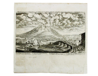
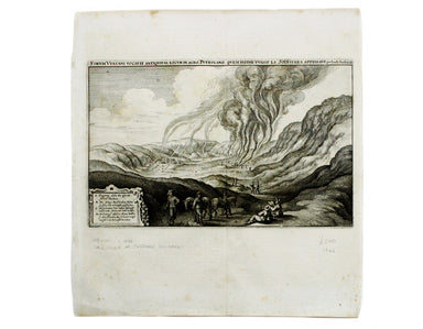
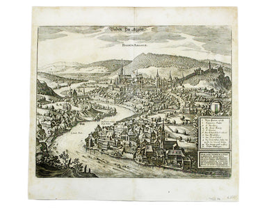
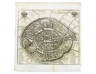
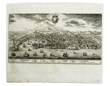
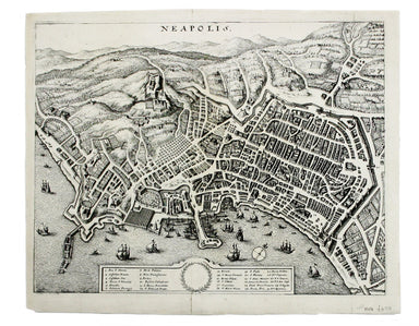
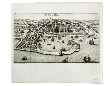
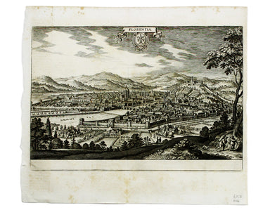
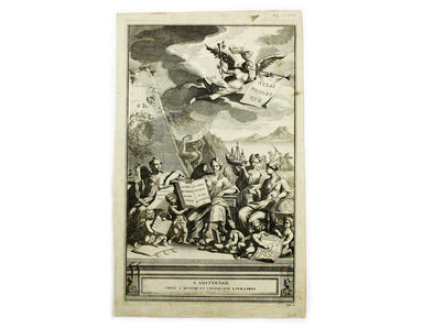
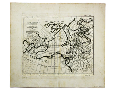
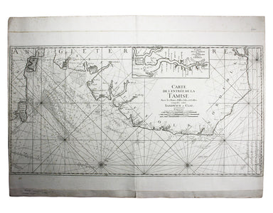
Bonne’s Map of Arabia: Padua Edition
Carte de L’Arabie, du Golfe Persique et de la Mer Rouge, avec L’Egypte, La Nubie et L’Abissinie This map of Arabia was published in an Italian edit...
View full details
Carte de L’Arabie, du Golfe Persique et de la Mer Rouge, avec L’Egypte, La Nubie et L’Abissinie This map of Arabia was published in an Italian edit...
View full details
This view shows the major eruption of Vesuvius in December 1631, published by Merian and his heirs in various works, including the Itinerarium Ital...
View full details
This is a view of the Solfatara volcanic crater, mythological home of Vulcan in the Phlegraean Fields at Pozzuoli, near Naples. It was published by...
View full details
This plan of of Ostia was published by Merian and his heirs in various works, including the Itinerarium Italiae of 1640, the Archontologia cosmica ...
View full details
This plan of Piacenza was published by Merian and his heirs in various works, including the Itinerarium Italiae of 1640, the Archontologia cosmica ...
View full details
This map of Baden in Switzerland was published by Merian and his heirs in various works, including the Archontologia cosmica, Theatrum Europaeum an...
View full details
This map of Stade was published by Merian and his heirs in various works, including the Theatrum Europaeum. Condition & Materials Copper engrav...
View full details
This map of Wismar was published by Merian and his heirs in various works, including the Theatrum Europaeum. Condition & Materials Copper engr...
View full details
This map of Aachen, or Aix-la-Chapelle, was published by Merian and his heirs in various works, including the Theatrum Europaeum. Condition & M...
View full details
This plan of Mantua was published by Merian and his heirs in various works, including the Itinerarium Italiae of 1640 and editions of the Theatrum ...
View full details
This plan of Genoa was published by Merian and his heirs in various works, including the Itinerarium Italiae of 1640 and editions of the Theatrum E...
View full details
This plan of Palmanova (a Venetian town founded in 1593, sheltered behind innovative fortifications taking the form of a nine-pointed star) was pub...
View full details
This plan of Loreto (site of the Basilica della Santa Casa) was published by Merian and his heirs in various works, including the Itinerarium Itali...
View full details
This plan of Pavia (the ancient Ticinum) was published by Merian and his heirs in various works, including the Itinerarium Italiae of 1640 and edit...
View full details
This plan of Naples was published by Merian and his heirs in various works, including the Itinerarium Italiae of 1640 and editions of the Theatrum ...
View full details
This plan of Messina was published by Merian and his heirs in various works, including the Itinerarium Italiae of 1640 and editions of the Theatrum...
View full details
This map of Bremen was published by Merian and his heirs in various works, including the Theatrum Europaeum. Condition & Materials Copper engra...
View full details
This map of Rostock was published by Merian and his heirs in various works, including the Theatrum Europaeum. Condition & Materials Copper eng...
View full details
This plan of Florence was published by Merian and his heirs in various works, including the Itinerarium Italiae of 1640 and editions of the Theatru...
View full details
[Title-page] Description de l’Univers Tome I This is the title-page for the first volume of Mallet’s Description de l’Univers printed by Denis Thie...
View full details
[Title-page] The English Atlas, Volume II Pitt worked in partnership with Janssonius’ heir Joannes van Waesbergen, and this title-page for the Germ...
View full details
[Title-page] Atlas Historique The classical muses on this title page represent Chronology, History, Navigation and Geography. Atlas braces himself ...
View full details
[Title-Page] Mercurio Geografico […] Tomo Secondo […] Condition & Materials Copper engraved title-page, 42 x 26.5 cm, black and white as issue...
View full details
Het Beloofde Landt Canaan door wandelt van onfen Salichmaeker Iesu Christo, nessens syne Apostelen Oriented to the west, this map of the Holy Land ...
View full details
Asia veteribus nota. L’Asie ancienne, dirigée par M. Philippe This is a map of Asia as it was understood in the Greco-Roman world in classical anti...
View full details
South America – British Guiana – Georgetown and mouths of Demerara and Essequibo Rivers This British chart of Georgetown shows soundings etc, with ...
View full details
This chart of Dublin bay shows soundings etc, with interior detail of relief and settlements (including eastern Dublin), and inset coastal profiles...
View full details
This British chart of Durban port was engraved by John and Charles Walker. It shows soundings etc, interior detail of relief and settlements includ...
View full details
Plan du Siege de Namur avec les nouveaux travaux que sa Majesté y a fait adjouter qui sont marquees à la lettre A. Cette place fut reduitte à l’obb...
View full details
Carte générale des découvertes de l’Amiral de Fonte, representant le grande probabilité d’un Passage au Nord Ouest Maps depicting the purported voy...
View full details
Plan Des Villes De Londres et de Westminster et leurs Faubourgs avec le Bourg de Southwark This is the first version of the map, before the date wa...
View full details
La Parte Orientale della Irlanda che comprende le Provincie di Ulster e Leinster This is the eastern sheet of Cassini’s pleasing and unusual two sh...
View full details
Pomeraniae Wandalicae Regionis Typ. [on sheet with] Livoniae Nova descriptio [and] Ducatus Oswieczensis et Zatoriensis Descriptio An early example ...
View full details
Carte de l’entrée de la Tamise, avec les Bancs, Passes, Isles et Costes comprises entre Sandwich et Clay This is a revised version of a chart which...
View full details
Port Florence [Kisumu, Kenya] Kisumu, a port on Lake Victoria, was surveyed as a terminus for the Uganda Railway in 1898. The railway was completed...
View full details
Parte Occidentale/Orientale del Governo Generale d’Orleans This map of the Duchy of Orleans is from Mercurio Geografico, an unusual and finely engr...
View full details
Governo Generale dell’Isola Di Francia (Île-de-France) This map of Île-de-France is from Mercurio Geografico, an unusual and finely engraved work. ...
View full details
Il Ducato di Bar diviso ne suoi tre Baliaggi de Barleduc, di S. Michel, e Bassigny […] e li Territorii della Citta e Vescovati di Metz, Tul e Verdu...
View full details
Il Ducato di Lorena (Lorraine) This map of Lorraine is from Mercurio Geografico, an unusual and finely engraved work. Condition & Materials Cop...
View full details
La Savoia divisa nelle sue Principali Provincie da Giacomo Cantelli da Vignola [….] This is a map of Savoy from Mercurio Geografico, an unusual and...
View full details
John Stow's A Survey of the Cities of London and Westminster was originally published in 1598 and 1603, but revised and expanded works under his na...
View full details
John Stow's A Survey of the Cities of London and Westminster was originally published in 1598 and 1603, but revised and expanded works under his na...
View full details
Plan of Coleman Street and Bassishaw Wards; Plan of Portsoken Ward; Plan of Cripplegate Ward Condition & Materials Copper engraving, 34 x 22 cm...
View full details
This view of Constantinople isfrom Mallet’s Description de l’Univers, first published in Paris in 1683 and reprinted with German text in Frankfurt ...
View full details
This plan of Constantinople is from Mallet’s Description de l’Univers, first published in Paris in 1683 and reprinted with German text in Frankfurt...
View full details
Constantinopoli / Descrittione di Constantinopoli First published in 1572, our example of Porcacchi’s map of Constantinople is from the second edit...
View full details
This map of Ancient Jerusalem is from Mallet’s Description de l’Univers, first published in Paris in 1683 and reprinted with German text in Frankfu...
View full details
This map of Alexandria is from Mallet’s Description de l’Univers, first published in Paris in 1683 and reprinted with German text in Frankfurt the ...
View full details