

Beyond Claret Country: Louis Larmat and the First National Wine Atlas
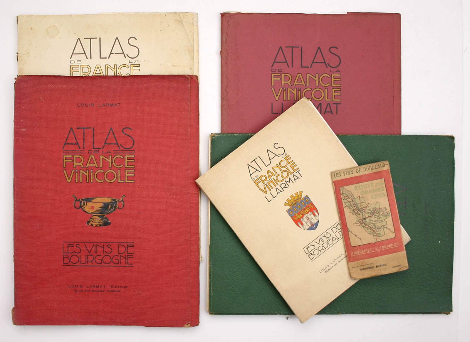
The world’s first national wine atlas was published in Paris by Louis Larmat between 1941 and 1947. Under the auspices of a number of national and regional bodies, but primarily the Comité National des appellations d'origine des Vins et Eaux de Vie, Larmat’s ‘Atlas de la France Vinicole’ covered the principal wine producing regions of France in six volumes:
Vol. 1: Les vins de Bordeaux, 1941
Vol. 2: Les vins de Bourgogne. 1942
Vol. 3: Les vins des côtes du Rhône. 1943
Vol. 4: Les vins de Champagne. 1944
Vol. 5: Les vins des coteaux de la Loire. 1er. partie. Touraine et Centre. 1946
Vol. 6: Les eaux-de-vie de France. Le cognac. 1947


This seems remarkably late. Winemaking in France predates the Romans, and wine-related imagery was popular on decorative early maps of wine-producing French regions. The Victorians revelled in specialist mapping and one might reasonably expect developments such as the 1855 classification of the leading Bordeaux wines (all but one in the Médoc, or the left bank of the Gironde) to have generated wine-specific examples: at the behest of Napoleon III, wine produced by the different estates was ranked in importance for the international audience at the Exposition Universelle de Paris, and this was done in considerable detail (the most important red Bordeaux wines were graded between Premiers Crus and Cinquièmes Crus). Sure enough a ‘Carte Vinicole du Département de la Gironde’ was published in Bordeaux in 1856; it was by local surveyor Unal Serres, and it was a reduced version of a map displayed at the Exposition. The first of many editions of the classic guide to Bordeaux wines, Cocks and Féret’s Bordeaux et ses vins, was published with a large folding map in 1850 (the other five plates were topographical views of subjects which might have illustrated any standard tourist guide). Wine mapping was underway.
There was a hiatus – trade was badly affected by the onslaught of American phylloxera aphids in the early 1860s – but the expanded 1868 edition was accompanied by a number of black and white engravings of the leading chateaux. A supplementary ‘Carte routière et vinicole du département de la Gironde’ published by Féret et fils was sold separately from at least 1873, and by the 1880s maps had become a significant feature of both French and English language editions. While they do not rival the quality of Larmat’s maps – they illustrated a humble guide book – they indicate the different wine regions and the location of the vineyards, and by my reckoning they are wine maps.
Hugh Johnson (who was unquestionably aware of Cocks and Féret) still chooses to give the credit firmly to Larmat: "The new appellations were beautifully mapped in the 1940s. Larmat’s were the only detailed wine maps of any country until the first edition of this Atlas <1971>. Since that date country after country has defined or redefined its vineyards and produced maps to prove it.((Hugh Johnson: World Atlas of Wine. 4th ed. Simon and Schuster 1994, p. 8.))" If we look at mapping on a national rather than a regional level, and sideline the pioneering 19th century wine mapping in the Bordeaux region, this appears to be true.
The clue to why Larmat’s work was published when it was lies in the phrase ‘new appellations’. The Comité National des appellations d'origine (CNAO) was established in July 1935, a collaborative effort between the French government and leading wine-makers to restore the industry’s fortunes in the aftermath of the Great Depression. Although the concept of AOC (appellation d'origine contrôlée) is earlier, the CNAO instigated the process of applying it systematically to wine-making. ‘Terroir’ was now of tremendous importance: it was regulated to the millimetre and backed by government legislation. An officially sponsored atlas makes a great deal of sense in this context, both as a marketing tool extolling the quality of wine produced under the rigorous new system, and as a record.


In 1939 the CNAO Bulletin announced the first volume of the ‘Atlas de la France Vinicole’, praising Larmat’s maps for their blend of scientific rigour, clarity and elegance; the price was 250 Francs. Publication may have been disrupted by the outbreak of war, but it was not derailed. Despite rationing wine and diverting the produce of the wine industry to other uses (including fuel), the Vichy regime continued to refine the system: ‘in Burgundy, the premier cru tier was created in 1943. In Bordeaux, a category of sparkling wine (Bordeaux Mousseux) was created in 1941, as was AOC Bordeaux Supérieur…’ (Rod Phillips: French Wine: A History. University of California Press, 2016) These measures (‘décrets’) are recorded faithfully in Larmat’s text. Other measures to improve the quality of AOC wines included mandatory de-stemming of grapes before pressing, raising the minimum alcohol level and restricting yield per hectare for each vintage, rather than taking an average over three or five vintages.
At same time, legislation introduced by the Vichy regime reduced the quality of the bulk of French wine (for example, by lowering minimum alcohol content, permitting more blending and permitting wider use of hybrid varieties). Widening the gap between AOC wines and the rest put even more emphasis on the importance of the vineyards covered in Larmat’s atlas.
Each volume was lavishly illustrated with large colour-printed folding maps and supplied with multilingual descriptive text, presented loose in portfolios. The arrangement of each volume is broadly similar. Somewhat flowery introductory remarks by representatives of national bodies, led by the President of CNOA, are followed by a general map and introduction to the region by the leader of the local syndicate. Detailed maps of areas of specialised production are accompanied by descriptive statements and details of the legislation, brought right up to date, which defined each AOC. The descriptive text is in French, English, German and Italian (and in some cases, Spanish and Portuguese). The export market was a driving force behind the original 1855 classification and Cocks & Féret was initially aimed at the English market (Cocks was an English wine enthusiast living in Bordeaux, approached by the publisher Féret to produce an English-language guide to claret country). Larmat’s work appears to have been no different in its intent, although with an eye to the return of some sort of normality post-war: the export market had more or less ceased to exist by 1941, even to neutral Scandinavian countries.
The text is illustrated with engravings and photographs depicting chateaux and vineyards, aspects of the wine making process and rural scenes, and both maps and text appear to have been revised between editions. Pinning down the sequence of those editions will prove a bibliographical minefield and I can appreciate why the institutional catalogues which I have encountered so far mostly sum them up as ‘numerous’. I suspect that the earlier volumes were revised and reprinted to satisfy demand as new volumes came out: for example, a set appears to have been issued 1944-1947, and there seem to have been further complete editions printed in 1949 and 1953 (the 1949 edition appeared in a smaller format, with reduced maps). Some volumes were issued as limited editions, but whether this was in advance of normal ‘trade’ editions, simultaneous with them, or standard for the first edition of each volume isn’t clear either. For example, in 1944 a limited edition of the Champagne volume appears to have been issued ‘avec les compliments de Messieurs G.-H. Mumm & Cie’ (the firm had been confiscated from the German family which had founded it at the end of the First World War, and returned to them in 1940, so perhaps they felt inclined to celebrate). But was that the only edition printed in 1944? Similarly, I’ve also spotted numbered promotional copies of volume 6, presented in 1947 by the Martell cognac house and by Denis-Mounié. The Martell example included a 12 page supplement with a history of the firm. It seems most likely (and simplest) that part of each run was set aside for major trade sponsors, but I think it will be necessary to compare a few more examples to understand how the numbering worked.


I do have two examples of the Bordeaux volume in front of me, the presumed second edition of 1944 and the third edition of 1949, so at least we can make a start. The 1944 edition is not a limited edition, that of 1949 is one of 800. The most obvious difference is format. The 1944 edition measures 46 x 34 cm and the sheets are loose in a red portfolio made of stiff, grained paper. The 1949 edition measures 32.5 x 25 cm and it is stitched: bound in the usual way, with cream card wrappers. This affects the size of the maps too. The general map of Bordeaux has been reduced from the folding 65 x 45 cm sheet published in 1944 to a single page of just 31.5 x 24 cm, printed on glossy paper stock rather than matt. But most regions have fared better: ‘Médoc’ was a single sheet in 1944, but is here split between a folding map of Haut Médoc on a folding sheet 31.5 x 58.5 cm, and a single-page map covering the rest of the region: although the two maps are smaller, individually, the region is covered on a fractionally larger scale than in 1944. The insets have gone, there are changes in nomenclature and presentation… it is not simply a reduced copy of the earlier map - it is a different thing. The 1944 edition contains 8 map sheets, that of 1949 has 16, of which 6 are folding. In terms of illustration, the 1944 edition has line drawing by ‘Bartho’; the 1949 edition is chiefly illustrated with photographs credited to a number of different sources (Engesser, Panajou-Salon and others) some of them presumably supplied by regional bodies. Textually, the 1949 edition has been updated with the latest ‘décrets’, bringing the legislation up to date. The text has been fully revised. In some cases this seems to be due to changes of personnel in the organisations sponsoring the volume, but even when the same people are still in place they have been invited to rework their contributions. Emmanuel Cruse was was president of l’Union des Syndicats Agricole et Viticole de la Région du Médoc in both 1944 and 1949, but a couple of brief introductory paragraphs covering characteristics and classification, with a brief aside about peasants (their love of their work, their distrust of progress) have been expanded to fill a page and a half describing the whole wine-making process (but retaining the riff on peasants, which obviously pleased him). I had been prepared to find that the 1949 edition was an austerity-era reprint in a smaller, cheaper format, perhaps with appendices tacked on to bring the legislation up to date. Instead I learned that it was an entirely new edition, well executed and with a great deal of additional material. Louis Larmat was evidently still extremely active, and if anyone reading this is thinking of building a comprehensive collection of wine atlases, I’m afraid you are going to need the different editions.


The full scope of the project was never realised. In 1947, at the conclusion of the Cognac volume, Larmat announced that he was preparing a second part of volume 5 (wines of the Loire) covering Anjou and Muscadet. Volume 6 would have been expanded with sections on Armagnac and Calvados; volume 7 would have been on the wines of Alsace and an eighth volume would have covered sweet, fortified wines: vins doux naturels and vins de liqueur.


Larmat may also have planned a series of road maps for self guided wine tours: ‘route des grands crus’. I have only located one covering the Bordeaux region so far, divided between two folding maps in stiff card covers, and with a copyright date of 1950. These are new maps, rather than straight reductions of the maps in the 1949 edition. The main roads are printed in red to give them prominence for the user, and there are vignettes depicting the various chateaux.
Finally, who was Louis Larmat, and why was he chosen for the job? Worldcat gives the year of his birth as 1890, but does not offer a date of death. The Bibliotheque Nationale de France suggests ‘19-’ for the former, notes that Larmat was male and an ‘Editeur parisien’ and offers two business addresses: ‘Adresse en 1943 : 10 bis rue Duhesme, Paris, 18e ; en 1949 : 80 boulevard Haussmann, Paris 8e.’ (This was something of a step upwards, perhaps comparable with moving from Kennington to Brompton Road.) Slim pickings so far. A small clue may lie in his earliest accredited publication: ‘Collection de plans reliefs


National bodies continued to promote French wines through cartography in the 1950s, but in a less scholarly way. For example, the Comité national de propagande en faveur du vin sponsored a delightful series of 11 pictorial maps by artist Remy Hétreau (1913-2001). Hétreau was the subject of a 2008 retrospective, ‘Un monde enchanté’, at the Centre Charles Péguy, Orleans. He studied art in Orleans and then at the École Boulle in Paris, a college of arts and crafts and applied arts. He was a versatile painter, sculptor and engraver, turning his hand to a wide range of projects, from set design to ceramics and from book illustration to poster design. He was President of the Société des Artistes Orléanais between 1964 and 1984.
Larmat’s maps continue to be of value 75 years after their creation. American wine critic Peter Liem celebrates their importance in his recent work on Champagne (Peter Liem: Champagne: The essential guide to the wines, producers, and terroirs of the iconic region. London, Mitchell Beazley, 2017). Having seen a reproduction he ‘realised that there was no other Champagne map, past or present, that so precisely and comprehensively identified parcels within each village’. Visiting the region with copies of the map he discovered that ‘growers were astonished; many had never seen them before. Vineyard owners had their own maps published by the local land registries… but region-wide maps that put these sites into context with others were rare…’ The usefulness of the maps lay sometimes in ‘preserving the individual identities’ of wine from a particular vineyard, but Liem was more interested in understanding the geology and geography of the region - the understanding of which, he suggests, enables growers to ‘create a more diverse and terroir specific array of base wines to use in their blends’. While there have been significant changes since the 1940s Liem found Larmat’s maps ‘invaluable, and they have changed the way I view the landscape of Champagne’. He included a facsimile set with his book: ‘outlining the classic growing areas they are the most detailed maps of the Champagne region that are publicly available’
----------
UPDATE
We’re still on the trail of Louis Larmat, and thanks to everyone who has joined in. No more information about the man himself, but my friend Angus discovered a reference to early - and highly effective - use of Larmat’s maps during the Second World War. Journalist Wynford Vaughan-Thomas recounts the situation in Burgundy in late 1944 in his wartime memoir (How I liberated Burgundy, Michael Joseph 1985, pp 152-3).
The Americans were concerned that the French were “doing a little bit of a go slow” in Burgundy. Arriving at French headquarters Vaughan-Thomas discovered why. What if the Germans decided to fight a strong rearguard action among the great vineyards? In the map tent he and the intelligence officer “looked thoughtfully at the Colonel’s private map of the German positions. They were marked - quite properly - on the relevant sheet of Larmat’s ‘Atlas Vinicole de France’… Then occurred one of those dramatic strokes which are the speciality of the French at war. A young sous-lieutenant entered, hurriedly saluted and, with a smile illuminating his face, declared, ‘Great news, mon colonel, we have found the weak point in the German defences. Everyone is on a vineyard of inferior quality’. We both recognised that we had reached a turning point in the battle”. Vaughan-Thomas accompanied the rapid French advance, “the undamaged vineyards stretching mile after mile before us”.

1946 dated business letter signed by Louis Larmat, courtesy of Antiqua Print Gallery
My colleagues at Antiqua Print Gallery unearthed a letter, typed in old commercial French, which is signed by Larmat. More or less ‘thanks for your kind letter, I would love to read your review of my atlas but I haven’t received a copy of your magazine for some months, and I’d like to re-subscribe’. Written on impressive headed stationery in December 1946, while the ‘Atlas Vinicole’ was still expanding, it offers a first, physical link with Larmat himself. But I haven’t given up hope that someone out there can help us compile a proper biography.
Leave a comment