

Underground Gallery
The London Underground is the world’s oldest underground railway. In the decade or so that I’ve been specialising in Tube maps I’ve seen spiralling interest in collecting the cartographic record of 150 years of underground travel. Hundreds of maps have been issued by London Transport, its immediate predecessor the London Passenger Transport Board, the Underground Electric Railways Company of London and the independent companies which ran individual lines in the early years of operation, before the system was unified. Collectors approach these maps from many different standpoints: as examples of London history, transport history or as works of art or industrial design. The interwar period in particular saw designs of the highest calibre commissioned from named artists and designers including MacDonald Gill, Fred Stingemore and, of course, Harry Beck. As I said, this is now a hugely popular collecting area and the web abounds with excellent sites which detail the chronological development of Underground mapping. Many of the earliest maps, such as the majority issued by the District Railway, simply overprinted the underground lines on large and unwieldy street plans of London. By the Edwardian era the surface detail was being weeded out, reduced to major roads, parks and other landmarks, and a further advance was the colour-coding of lines (a joint branding exercise introduced by the UERL). In the 1920s Gill and Stingemore stripped away the surface topography altogether, even toying with removing the Thames, although the river was swiftly reinstated as a point of reference. Passenger maps were also getting smaller, resulting, after a couple of false starts, in the tri-fold pocket maps which are still given out at stations today. Beck inherited 60 years of r. and d. The cover of the first edition of his contribution to the genre, published in January 1933, even bears the coyly worded disclaimer “A new design for an old map. We should welcome your comments” (LPTB really wasn’t sure it would catch on). All previous maps had been in some sense geographical, even if lines were occasionally distorted due to constraints of space, but Beck’s astonishingly bold and simple idea was to redraw the map as a diagram. It’s possibly the most original piece of cartography of the twentieth century. The legacy for modern Tube passengers is clear enough: Beck is still credited on every map. Beck’s idea has also influenced metro mapping around the world (even if it hasn’t always stuck, in its purest form; witness the controversy over Vignelli’s designs for the New York Subway), he inspired several generations of artists and a whole genre of entertaining pastiches best described as ‘Becksploitation’. The instantly recognisable design, in its many forms, now adorns everything from cushion covers to mouse mats. And that’s the other thing - the development of Underground mapping doesn’t hit the buffers in 1933. Beck himself tinkered with the design for the best part of thirty years (with a brief interlude 1938-41), experimenting with angles, grids, compass roses, ways of showing interchange stations … there is far more to his changes than the fundamental requirement of showing developments on the network. Well, so much for the background. There’s no space here to go into much more detail - this could easily become a book rather than a blog post. But I generally have a couple of hundred Underground maps in stock, from quirky early advertising pieces (maps printed on postcards, tape-measures, menus …) through to the big quad royal posters designed for display in stations, and a decent selection of the small pocket maps which were tipped into guide books or given away free to passengers. Here are a few of the more unusual ones, including some I’ve only ever seen once. 'Specials' were customised to advertise events such as exhibitions, or even private companies. In the late nineteenth-century a series of miniature District Railway maps were issued, adapted for the various exhibitions held at Olympia and often tipped into the accompanying exhibition guides.
 District Railway 1883 fisheries exhibition

District Railway 1892 Constantinople

London Electrified 1908

CLR Japan Exhibition 1910

Public Benefit Boot Co 1900

Public Benefit Boot verso

Pears soap

Spencer Turner Bolero promotional 1910

Pickfords promotional relic

Beck Peter Robinson overprint 1933

Football grounds 1924

Hampstead Tube 1907 cover

Hampstead Tube map

GNPBR 1906

Central London Railway 1902

CLR common design 1912

GNR 1914

Evening news Tube map 1907

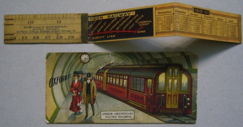
CLR 1910 tape measure

Excursionists Guide 1911

Gill Underground maps

Gill 1923

Gill lilac variant 1922

Perman overprint

Stingemore extensions 1930

Trifold firsts

Underground poster 1917

1938 Quad Royal

1946 Quad Royal

Stingemore Boat Race
Leave a comment