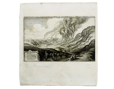
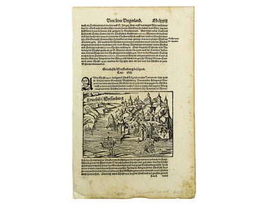
Merian’s View of the Solfatara Crater
This is a view of the Solfatara volcanic crater, mythological home of Vulcan in the Phlegraean Fields at Pozzuoli, near Naples. It was published by...
View full details
This is a view of the Solfatara volcanic crater, mythological home of Vulcan in the Phlegraean Fields at Pozzuoli, near Naples. It was published by...
View full details
A New and Correct Map of North Wales Robert Morden's maps were engraved to illustrate Gibson's edition of William Camden's Britannia, first publish...
View full details
This of Cape Verde was published 'Geography Rectified' in various editions from 1680 onward. Condition & Materials Copper engraving, 11.5 x 13...
View full details
Kriechich Wyssenburg This map of Belgrade showing the confluence of the rivers Danube and Sava at Belgrade, Serbia, is from Sebastian Münster's Cos...
View full details
This map of Sicily is from the second series of maps engraved by Philip Galle for the Epitome, the pocket atlas version of Ortelius’ Theatrum. Cond...
View full details
Two English printers dipped a toe in the vernacular atlas market at approximately the same time with pocket editions of the Ortelius atlas: ‘These ...
View full details
Typus Regni Neapolitani This map of the Kingdom of Naples is from the second series of maps engraved by Philip Galle for the Epitome, the pocket at...
View full details
Asia veteribus nota. L’Asie ancienne, dirigée par M. Philippe This is a map of Asia as it was understood in the Greco-Roman world in classical anti...
View full details
Tabula Aphricae II Ruscelli’s map of North Africa, following Gastaldi, was first issued in his edition of Ptolemy’s Geographia printed by Valgrisi ...
View full details
This map of Ptolemaic Germany and Denmark is from the fourth edition of Ruscelli’s Italian translation of the Geographia. It is illustrated with de...
View full details
[Title-page] Anglorum Indoles Studia et Actiones In attempting to define the character of the English there is a strong emphasis on trade and disco...
View full details
[Title-page] Atlas Historique The classical muses on this title page represent Chronology, History, Navigation and Geography. Atlas braces himself ...
View full details
West Indies – St Croix Island – Christiansted Harbour This is a US naval chart of Christiansted, the largest town on St Croix in the United States ...
View full details
Japan – Honshu – South Coast – Kii Suido – Yurano Uchi and Hii Wan This sea chart covers a stretch of coastline to the south of Osaka and Wakayama ...
View full details
Britannia Magna This miniature map of the British Isles oriented with East at the top was published in James Beeverell’s ‘Les Delices de la Grand B...
View full details
In the margin to the left of this map is an incomplete list of sultans of the Ottoman Empire. The map was published in Wagner’s ‘Delineatio Provinc...
View full details