

Lehmann-Dumont’s Satirical Map of Europe in 1914
SKU: 8539
Title:
Lehmann-Dumont’s Satirical Map of Europe in 1914
Date of publication:
Printed Measurement:
Colour:
Mapmaker:
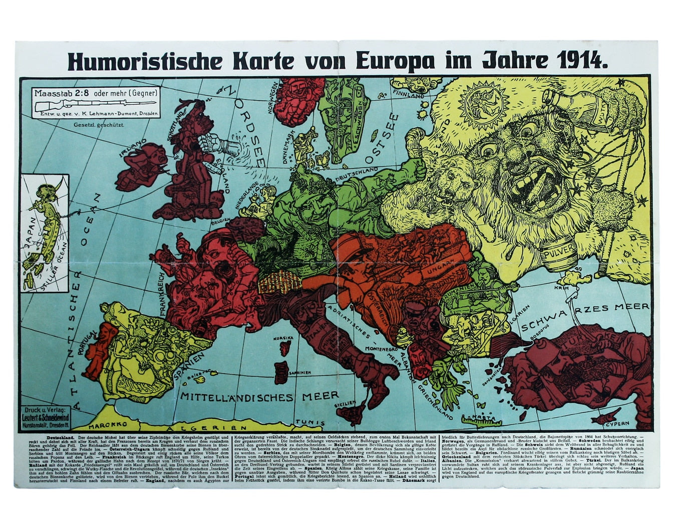
This intricate anthropomorphic map (the artist also produced a zoomorphic companion piece) was issued soon after the outbreak of the First World War.
Italy, initially neutral, pokes a head from a giant boot, eyes swiveling in both directions while contemplating which way to jump. This is a German map, and the Central Powers are the heroes of the piece. Read more
Bees issuing from a German hive represent the scions of the nobility. Spreading out across the continent they are stinging the crazed, boss-eyed Russian bear into submission. They are accompanied by zeppelins, one of which is jabbing Britain (this time an Englishman in a pillbox hat) in the guts, while a mailed fist emerging from the North Sea delivers a further devastating blow (presumably representing the Imperial Navy’s High Seas Fleet, and possibly even referencing the early coastal bombardments of towns such as Scarborough).
Ireland and India are both presented as liabilities: Ireland attempts to sever the chain which binds him while an Indian snake is constricting the bulldog (all rather wishful thinking on the cartoonist’s part – the contribution of both nations to the Allied war effort was enormous, but this is propaganda… ). Note the sacks of money which support the Englishman’s weight, implying that Britain bankrolls others to fight, without raising and sending large armies to the continent.
The Ottoman Turk is shown reclining, his arm in a sling, lightly wounded by the Balkan Wars of 1912-1913, but a lit candle impaled on the tip of a scimitar in his other hand threatens to explode the powder keg under the loutish, drunken Russian. The outline of the Crimean peninsular becomes a puff of smoke - an ingenious use of cartography. One can read a great deal into a map such as this, but the topical jokes and puns would have been readily understood by the intended audience in 1914, and a detailed explanation beneath the map clears up the finer points.
Condition & Materials
Satirical map of Europe, 35 x 50 cm, printed in colours, splits to folds, laid on tissue, blank verso. Read less