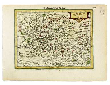

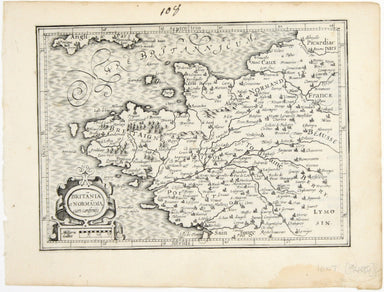
Mercator’s Miniature Map of Brittany & Normandy
Britannia et Normandia cum consiniis This map of Brittany and Normandy was engraved by Jodocus Hondius for the ‘Atlas Minor’. Condition & Mater...
View full detailsBritannia et Normandia cum consiniis This map of Brittany and Normandy was engraved by Jodocus Hondius for the ‘Atlas Minor’. Condition & Mater...
View full detailsThis map of Île-de-France, the Paris region north of the Seine, is from the Atlas Minor. The original plates were engraved by Jodocus Hondius, but ...
View full detailsThis is Mercator's map of Pays Boulonnais and Guînes from the Atlas Minor. The original plates were engraved by Jodocus Hondius, but after these we...
View full detailsThis map of Southern Lorraine is from the Atlas Minor. The original plates were engraved by Jodocus Hondius, but after these were sold to the Londo...
View full detailsThis map of Northern Lorraine is from the Atlas Minor. The original plates were engraved by Jodocus Hondius, but after these were sold to the Londo...
View full detailsThis map of Anjou is from the Atlas Minor. The original plates were engraved by Jodocus Hondius, but after these were sold to the London trade in t...
View full detailsThis map of the province of Berry in central France is from the Atlas Minor. The original plates were engraved by Jodocus Hondius, but after these ...
View full details