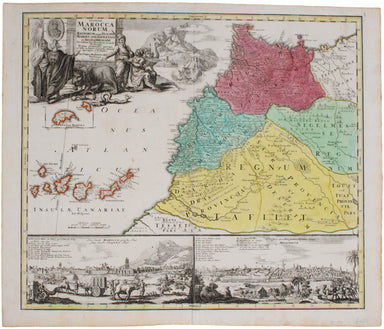
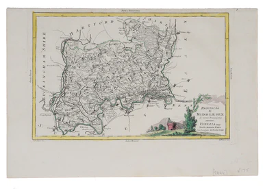
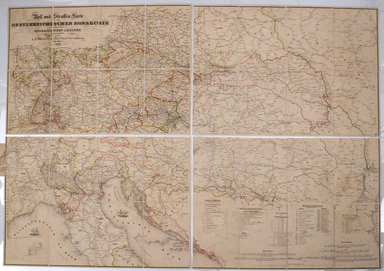
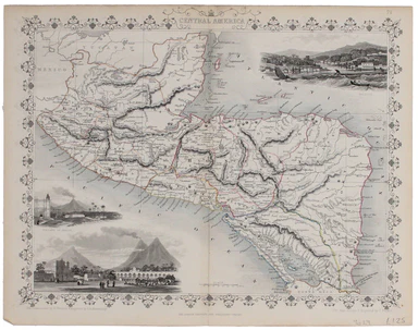
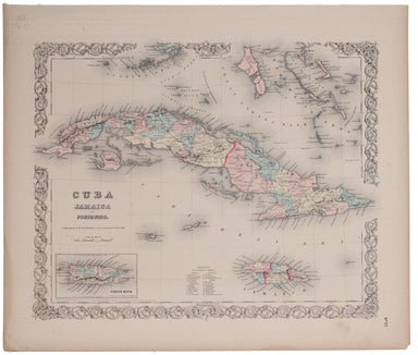
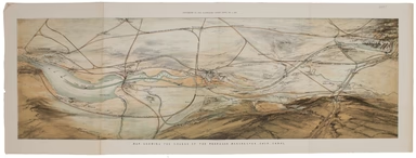
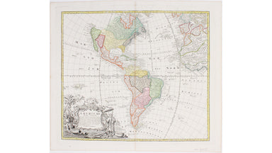
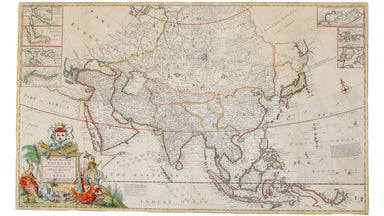
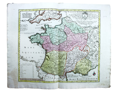
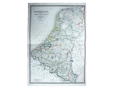
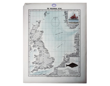
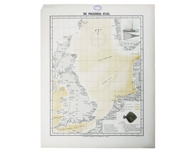
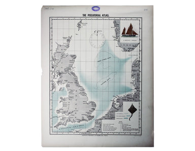
Pictorial Route Map of the Devon General
This pictorial route map of the Devon General by an anonymous draughtsman for the principal bus operator in south Devon makes playful references to...
View full details
This pictorial route map of the Devon General by an anonymous draughtsman for the principal bus operator in south Devon makes playful references to...
View full details
This Vietnam War-era city plan of Saigon (modern Ho Chi Minh City) is coloured by district, with a street index at the foot of the map. Useful info...
View full details
Also published in Stanford’s London Atlas, our example of this map of Africa was separately issued and illustrates the speed and scale of the Scram...
View full details
The Daily Mail Special Map Of The Far East Produced to illustrate the Russo-Japanese War, this map indicates Treaty Ports, dockyards and naval base...
View full details
Plan Routiere de la Ville et Fauxbourgs de Paris divisé en douze Maries, revu et corrigé par Hérisson, géographe Our map shows the Paris of Charles...
View full details
Théâtre de la Guerre: Carte de l’Empire Ottoman en Europe et en Asie With an inset of Sevastopol, our map covers the region at the outbreak of the ...
View full details
This steamship route map of the western Mediterranean and Northwest Africa shows the routes from Marseille and Bordeaux to Tunisia, Algeria and Mor...
View full details
This anthropomorphic map of Ireland was published in “Geographical Fun: Being Humorous Outlines of Various Countries”. Though credited on the title...
View full details
Though credited on the title-page under his pen-name ‘Aleph’, William Harvey himself gives all the credit for this series of comic maps to a “young...
View full details
Though credited on the title-page under his pen-name ‘Aleph’, William Harvey himself gives all the credit for this series of comic maps to a “young...
View full details
Thus anthropomorphic map of Holland and Belgium was published in “Geographical Fun: Being Humorous Outlines of Various Countries.”. Though credited...
View full details
The British Empire Exhibition originally ran between April and November 1924, but it was not a financial success, and the decision was taken to reo...
View full details
The British Empire Exhibition was, at the time, the largest exhibition staged anywhere in the world; a high profile, postwar statement of confidenc...
View full details
This route map advertises passenger, postal and cargo steamship services between Marseille and West Africa. The SS Canada was built for the Fabre L...
View full details
This anthropomorphic map depicting Wales as "Owen Glendowr, in Bardic grandeur" is from 'Geographical Fun: Being Humorous Outlines of Various Count...
View full details
The cartouche on this map of the British isles is surmounted by the old Stuart coat of arms and the borders are made up of sixteen regional armoria...
View full details
John Thomson's map of Korea and Japan was engraved by John and George Menzies in 1814 and published in his ‘New General Atlas’ in 1815. Walter sugg...
View full details
This map of Morocco was one of only two original maps engraved by the son of Johann Baptist Homann, Johann Christoph, in his short life (1701-30). ...
View full details
This map of Middlesex was published in Reuben Ramble's ‘Travels through the Counties of England’, an uncommon county atlas for children. Reuben Ram...
View full details
This map of Middlesex was engraved by Giuliano Zuliano after Giovanni Pitteri and published in Antonia Zatta's ‘Atlante Novissimo’. This was his ...
View full details
Folding map showing the post roads of the Austro-Hungarian Empire. Condition & Materials 4 folding engraved map sheets, which can be joined, e...
View full details
This map of Central America was engraved by John Rapkin for John Tallis' popular ‘Illustrated Atlas’. It includes black and white vignettes of Beli...
View full details
This map of Nova Scotia was engraved by John Rapkin for John Tallis' popular ‘Illustrated Atlas’; it includes black and white vignettes of Halifax,...
View full details
The map of the Eastern Hemisphere tracks the overland route to India (subject of a separate map in the series) and on to Australia. John Tallis the...
View full details
The Railway Clearing House allocated revenue on occasions where one company’s train ran over another’s track, and promoted standardisation (of ever...
View full details
This is one of the most detailed mid-19th Century American atlas maps of Cuba and the region, set within Colton’s distinctive style of border, by o...
View full details
This map of London was published in the Report of the Royal Commission on London Traffic, a detailed eight volume investigation of the nature, admi...
View full details
The 'Revoltas da Armada', the Brazilian naval mutinies of 1893-1894, were linked with the Federalist Rebellion against the recently-formed First Br...
View full details
The Empire of Morocco, since 1912, had been divided between the Spanish and French. Our map dates to the period of the Rif War, 1921-26, in which a...
View full details
This map of South Africa was published by The Times during the Second Anglo-Boer War, for the benefit of members of the British public following th...
View full details
This plan of the Manchester Shipping Canal was published as a supplement to ‘The Illustrated London News’, February 3rd 1883. Construction began in...
View full details
New Road Map of England & Wales... shewing all the lines of railway, canals &c., describing the picturesque scenery and forming a complete ...
View full details
This pictorial plan of central Oxford was printed for the recently nationalised British Railways (Western Region). The arms of the University and t...
View full details
Please note: this is not an 11th century manuscript map, it is the first printed edition (centuries after the map was drawn) following its rediscov...
View full details
This pictorial map of London is generally dated 1931 in institutional catalogues, but here Geographia’s date-code for November 1934 is worked into ...
View full details
This pictorial map depicts various London ‘types’ in the borders, and shows the Royal Festival Hall (built for the 1951 Festival of Britain) and th...
View full details
Our map of the Americas was prepared for the Homann firm by Johann Matthias Hase, professor of mathematics in Wittenberg, on his stereographic hori...
View full details
Moll's map of Asia is dedicated to William Cowper (1665-1723), the first to hold the office of Lord Chancellor (and from 1718 the first Earl Cowper...
View full details
A first edition of the famous diagram from January 1933 Beck’s diagram is one of the most innovative and influential designs of the twentieth centu...
View full details
Gallia Augustiniana in suas provincias divisa… A map of Roman Gaul, with Lotter’s imprint. In 1756 Lotter succeeded his father-in-law, Georg Mattha...
View full details
This characteristically clear and elegant map of Herefordshire is by John Cary, one of the leading cartographic engravers, publishers and globe-mak...
View full details
Garbutt believed he had ‘rescued’ the London Underground map from the clutches of Harold Hutchison and his ‘ham-fisted parody’ of Beck’s designs ...
View full details
Départment de la Corse A map of Corsica from an edition of Levasseur’s ‘Atlas National Illustré’. Condition & Materials Steel engraving, engrav...
View full details
Come for the Stone Age remains, stay for the rawhide... This simplified map of Malta and Gozo is surrounded by views, statistics and historical inf...
View full details
This simplified map of Cyprus was a visual aid published as sheet 4 in a portfolio titled ‘Empire Information Project. The island is surrounded by ...
View full details
Terra Firma et Novum Regnum Granatense et Popayan This regional map covers Colombia and neighbouring parts of present day Panama, Ecuador, Costa Ri...
View full details
Sarmatia utraque Europaea et Asiatica This map shows parts of European Russia and Ukraine in antiquity. For Greco-Roman geographers and ethnographe...
View full details
District within ¼ mile radius [of] South Harrow Stanford’s was a firm of map publishers as well as map retailers until after the Second World War, ...
View full details