Robert de Vaugondy’s Map of Hungary & Southeastern Europe
Le Royaume de Hongrie, Principaute de Transilvanie, Sclavonie, Croatie, et partie de la Principaute de Valaquie, de la Bosnie, de la Servie et de l...
View full details
Le Royaume de Hongrie, Principaute de Transilvanie, Sclavonie, Croatie, et partie de la Principaute de Valaquie, de la Bosnie, de la Servie et de l...
View full details
Archipel des Indes Orientales, qui comprend les Isles de la Sonde, Moluques et Philippines, tirées des Cartes du Neptune Oriental This map of Indon...
View full details
L’Empire de la Chine dressé d’apres les Cartes de l’Atlas Chinois This detailed and relatively accurate map of China, Korea and Taiwan was derived ...
View full details
This is a view showing London before the Great Fire, from the South Bank of the Thames, including London Bridge and old St Paul’s. Principal buildi...
View full details
This map of South Africa, including an inset of Cape Town, was engraved by John & Charles Walker. It was published by the SDUK. The Society for...
View full details
Blatt 29. Warmbad This map covers the Karas region in modern Namibia (then German South West Africa), which was the scene of one of the earliest at...
View full details
Mae Nam Wen and Entrance, Surveyed by the Hydrographic Department, Royal Thai Navy, March-May 1944 This is a Thai chart of the Mae Nam Welu estuary...
View full details
Published in March 1935, this is a commercially available map showing the operating area of the recently formed London Passenger Transport Board, a...
View full details
This map of Sri Lanka was published in the first trade edition of Stanford’s ‘London Atlas’. Edward Stanford (senior) acquired Arrowmsith's stock i...
View full details
Beck’s diagram is possibly one of the most innovative and influential designs of the twentieth century. First published in 1933, Beck remained dire...
View full details
District within ¼ mile radius [of] Paddington Praed Street Stanford’s was a firm of map publishers as well as map retailers until after the Second ...
View full details
Garbutt believed he had ‘rescued’ the London Underground map from the clutches of Harold Hutchison and his ‘ham-fisted parody’ of Beck’s designs. H...
View full details
The introduction of Beck's diagram did not obviate the need for geographically accurate maps, which pinpointed the location of Underground stations...
View full details
De Maginot – En Siegfried Line. Met alle steden, germeenten, spoorwegen, verstingen en versterkingen, bosschen, heuvels, enz. This map was publishe...
View full details
This map of the world is coloured by continent, with the exception of Russian America which is coloured as an extension of Asia. It was published i...
View full details
This map of Poland was engraved by Samuel John Neele for the atlas volume to ‘Cruttwell’s Gazeteer’, published by G & JJ Robinson. Condition &a...
View full details
Syriae sive Soriae, nova et accurata descriptio Petrus Schenk and Gerard Valk often worked in partnership, towards the end of the Dutch Golden Age,...
View full details
This map of New Zealand was published in the second trade edition of Stanford’s London Atlas. Edward Stanford (senior) acquired Arrowmsith's stock ...
View full details
La Castille Vieille et Nouvelle This map shows Old and New Castile in central Spain. Condition & Materials Copper engraving, 44.5 x 55.5 cm, or...
View full details
Cheffins’s Map of the English & Scotch Railways Cheffins’s Map of the Railways in England & Scotland, accurately delineating all the lines ...
View full details
Kreigs Expeditions Karte in Bohmen I Blat, in welchern die Haubstadt Prag mit der Franzofsischen und Saechsischen Belegerug und Eroberung, so den 2...
View full details
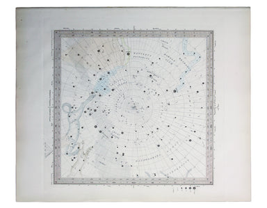
The Stars in Six Maps, on the the Gnomonic Projection, revised by the Rev. WR Dawes These star charts show allegorical images of the various conste...
View full details
Chart of the South East Coast of Arabia from Ras Sukra to Palinurus Shoal, compiled from trigonometric Surveys First published in 1860 with correct...
View full details
This intricate anthropomorphic map (the artist also produced a zoomorphic companion piece) was issued soon after the outbreak of the First World Wa...
View full details
Bacon’s Large Scale Plan of the City of London –Bacon’s Coloured Plan of the City of London… “Blitzed” areas shown A highly detailed map of London ...
View full details
This map of Burma was published in the second trade edition of Stanford’s London Atlas. Edward Stanford (senior) acquired Arrowmsith's stock in 187...
View full details
This map attempts full integration of bus and coach routes, tramways, the Underground and main-line railways, and is possibly the first issue showi...
View full details
In 1933 the Met became part of the LPTB. Here though, the Tube and other railways fade into the background. The emphasis is on work/life balance, c...
View full details
Blaeu’s map of Herefordshire. Blaeu and the rival Golden Age Dutch cartographic publishing house of Janssonius raced to bring out atlases of the Br...
View full details
The Bay of Gibraltar. With a plan of the Town, Rocks and Fortifications of Gibraltar as they now are. Also a plan of Algezira… Copied from the Drau...
View full details
The Seven United Provinces This map of the Netherlands was prepared for Playfair’s New General Atlas. Condition & Materials Copper engraving, ...
View full details
This plan of Tienen in Flanders is from the Civitates Orbis Terrarum, one of the most significant cartographic works of the late sixteenth-century,...
View full details
Mappa Totius Mundi adornata juxta Observationes dnn. Academiae Regalis Scientiarum et nonnullorum aliorum secundum annotationes recentissimas edita...
View full details
Signed limited edition screenprint Colour screenprint, sheet size 78 x 57.5 cms, signed by the artist and inscribed 'AP' (Artist’s Proof) in pencil...
View full details
Topographia Repraesentio Barbarici Portus et Urbis Munitae Oran … Oran, an important trading port and now Algeria’s second city, was governed by th...
View full details
“Hell on Wheels” War Against the Axis 1942 – 1943 – 1944 The lower panel of this map deals with operations in North Africa and Sicily, with the uni...
View full details
First published in 1914, this revised edition highlights administrative boundaries. Though technically administered jointly by Egypt and Britain be...
View full details
This map of Frankfurt, view of the city at the foot of the map, was published by the SDUK. The Society for the Diffusion of Useful Knowledge was fo...
View full details
Ceretica sive Cardiganensis Comitatus; Anglis Cardigan Shire Blaeu and the rival Golden Age Dutch cartographic publishing house of Janssonius raced...
View full details