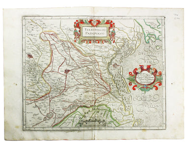
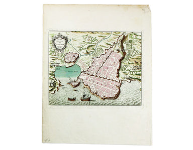
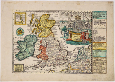
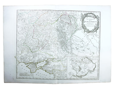
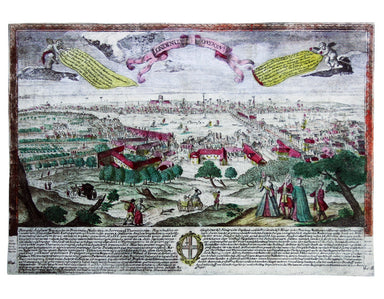
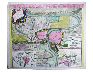
Braun & Hogenberg’s Plan of Autun with Nevers
This map includes French town plans after Belleforest on one sheet: Autun in Burgundy and Nevers in Bourgogne. They are from the Civitates Orbis Te...
View full details
This map includes French town plans after Belleforest on one sheet: Autun in Burgundy and Nevers in Bourgogne. They are from the Civitates Orbis Te...
View full details
This map of Mons in Belgium is shown with Arras in northern France. It is from the Civitates Orbis Terrarum, one of the most significant cartograph...
View full details
This map of Huntingdonshire was prepared for Anglia Contracta, Seller's miniature county atlas. Seller's atlases are notoriously difficult to date ...
View full details
Das Irische und Kaledonische Meer mit Seinen Inseln This map focuses on the islands off the coast of Scotland and in the Irish Sea, and it's from f...
View full details
This map of Merionethshire was prepared for Anglia Contracta, Seller's miniature county atlas. Seller's atlases are notoriously difficult to date b...
View full details
This map of Dresden engraved by William Henshall after William Barnard Clarke. Condition & Materials Steel engraving, 33 x 37 cm, original han...
View full details
Condition & Materials Copper engraving, 28.5 x 35 cm, original hand-colour map of the Duchy of Lorraine, blank verso.
This map of Toulon was engraved by BR Davies after WB Clarke. Condition & Materials Steel engraving, 33 x 40 cm, original hand colour, blank ve...
View full details
France divided into Metropolitan Circles and Departments This map was engraved by Samuel John Neele for the atlas volume to Cruttwell’s Gazeteer, p...
View full details
This map of the United Kingdom of the Netherlands is from 'A Modern and Ancient General Atlas, comprehending all the Empires, Kingdoms, States in t...
View full details
A Plain Map of the Central Part of Europe. According to the Method of the Abbé Gaultier by Mr Wauthier his Pupil This map of Central Europe is from...
View full details
This map of Germany was engraved by John Rapkin for the Illustrated Atlas. John Rogers engraved a number of vignettes: the Palace at Saxe Gotha, bi...
View full details
This map of the Principality of Lüneburg incorporates the former County of Dannenberg. The cartouche illustrates a stag hunting scene, perhaps on ...
View full details
Condition & Materials Copper engraving, 10.5 x 12.6 cm, original hand-colour, lightly browned, blank verso; leaf from the same work, with the ...
View full details
This map of Belgium was engraved by John Rapkin for the Illustrated Atlas. Vignettes including Antwerp cathedral and monuments on the plains of Wat...
View full details
This map of Crimea was engraved by John Rapkin for the Illustrated Atlas. The inset is described as ‘Sebastopol before its investment’ (i.e. before...
View full details
This map of the Baltic Sea was engraved by John Rapkin for the Illustrated Atlas. Vignettes including Kronstadt and St Petersburg were engraved by ...
View full details
This map includes a panoramic view of Parma at its foot, blank. The Society for the Diffusion of Useful Knowledge was founded in 1826 with the high...
View full details
This significant and original regional map of Padua is from Magini's great work, the first detailed national atlas of Italy, published posthumously...
View full details
This map of the Balearics, Corsica, Sardinia and Valetta was published by the SDUK The Society for the Diffusion of Useful Knowledge was founded in...
View full details
This map of Turin was published by the SDUK. The Society for the Diffusion of Useful Knowledge was founded in 1826 with the high-minded aim of maki...
View full details
Condition & Materials Copper engraving, 21 x 25.5 cm, original hand-colour, on a folio leaf 37 x 29 cm, blank verso.
This was the first official London Underground passenger map to be printed since spring 1943, at least partly due to paper shortages. When printed ...
View full details
Underground Railways of London What to see and how to travel: Map of the Electric Railways of London Condition & Materials Summer 1925 issue of...
View full details
Karte von der Insel St Lucia This map of the Caribbean island of St Lucia was published in the Dutch edition of Prévost's Histoire Générale des Voy...
View full details
This map of the British Isles and northwestern Europe charts George Edwards's travels between 1716 and 1730 and features male and female stag beetl...
View full details
Scandinavia complectens Sveciae, Daniae et Norvegiae Regna ex novissimis subsidiis delineata et ad Leges Projectionis Stereographicae legitimae red...
View full details
Graeciae Pars Meridionalis / Graciae Antiquae Tabula Nova in qua locorum situs tum ad distantias itinerarias tum ad Observationes Astronomicas exac...
View full details
Gros Britanni[en] oder Engelland Schottland und Irrland The cartouche of this map is dominated by the Hanoverian coat of arms, and the legend on th...
View full details
At the foot of this map are architectural elevations of some of Rome’s most famous post-classical buildings, dominated by St Peter’s. Rome was then...
View full details
This map of Australia has a table in the bottom left, showing the European population (supposedly revised to 1846 but with the original figure give...
View full details
Metropolitan Goods Conference Map of Collection & Delivery Boundary This map is a variant of the London plan typically issued with Kelly’s Dire...
View full details
An accurate map of the County of Worcester divided into its hundreds and drawn from the best authorities. Illustrated with historical extracts rela...
View full details
British Empire Throughout the World Exhibited in One View This is a highly decorative map of the British Empire by John Bartholemew, with British p...
View full details
Survey of the country around London to the distance of thirty two miles from St Paul’s The map extends between Ware and Chatham, Bray and Dorking. ...
View full details
District within ¼ mile radius [of] Manor House Stanford’s was a firm of map publishers as well as map retailers until after the Second World War, w...
View full details
Garbutt believed he had ‘rescued’ the London Underground map from the clutches of Harold Hutchison and his ‘ham-fisted parody’ of Beck’s designs. H...
View full details
This is an LNER colliery map covering the midlands and north of England and Wales ('Collieries in Yorkshire, Nottinghamshire, Derbyshire, Lancashir...
View full details
Blome published the first new series of county maps in the sixty years since the appearance of John Speed’s ‘Theatre’. In the straightened financia...
View full details
The United Nations was established in October 1945, and Bullock’s map is a joyful celebration of what promised to be a more effective successor to ...
View full details
Partie Méridionale de la Russie Européenne This is a late state of Robert de Vaugondy’s map of southern Russia, Ukraine and parts of Poland. The or...
View full details
District within ¼ mile radius [of] Uxbridge Stanford’s was a firm of map publishers as well as map retailers until after the Second World War, with...
View full details
The guide seems to have been aimed at an American audience, with several pages devoted to converting prices in pounds, shillings and pence into dol...
View full details
This Central London Railway map is similar in style to the UERL common design which had been in circulation since 1908, although with a chocolate r...
View full details
Benjamin Getzel Lewis' map of the London underground shows the Victoria Line under construction in the originally proposed colour Lewis (1900-1966)...
View full details
The Evening News was responsible for coining the name ‘Bakerloo Line’ for the Baker Street and Waterloo Railway, and here the newspaper makes a rel...
View full details
Carte de l’Italie, dans laquelle sont tracées les Routes des Postes This is a later state of Robert de Vaugondy’s road map of Italy, showing the Ve...
View full details
Le Royaume de Boheme, le Duche de Silesie, et les Marquisats de Moravie et Lusace, dressés d’apres les cartes de Muller The second state of Robert ...
View full details