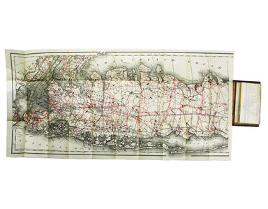
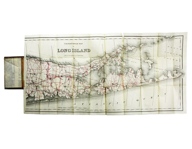
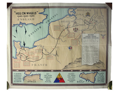
Colton’s Map of Long Island
Condition & Materials Lithographed in red and black on two sheets, each 38.5 x 80 cm; this map of Long Island is printed on thin india paper; ...
View full detailsCondition & Materials Lithographed in red and black on two sheets, each 38.5 x 80 cm; this map of Long Island is printed on thin india paper; ...
View full detailsBritish Empire Throughout the World Exhibited in One View This is a highly decorative map of the British Empire by John Bartholemew, with British p...
View full detailsPrinted in December 1964, this is an early iteration of Garbutt’s design, which had been unveiled to the public in May. Garbutt believed he had ‘re...
View full detailsGarbutt believed he had ‘rescued’ the London Underground map from the clutches of Harold Hutchison and his ‘ham-fisted parody’ of Beck’s designs ...
View full detailsGarbutt believed he had ‘rescued’ the London Underground map from the clutches of Harold Hutchison and his ‘ham-fisted parody’ of Beck’s designs. H...
View full detailsLondon: Day & Son for FG Moon, 1846-49. Tinted lithograph by Louis Haghe after Roberts, 48 x 32.5 cm, closed marginal tear (not affecting imag...
View full details“Hell on Wheels” War Against the Axis 1942 – 1943 – 1944 The lower panel of this map deals with operations in North Africa and Sicily, with the uni...
View full detailsHarold Hutchison believed that he could design a superior version of the Beck diagram himself. He was wrong. With a print code dated January 1960, ...
View full detailsThe critics have not been kind to Harold Hutchison, and nor have we. His design, which replaced Beck’s diagram, was unveiled to the public – and to...
View full detailsThis intricate anthropomorphic map (the artist also produced a zoomorphic companion piece) was issued soon after the outbreak of the First World Wa...
View full detailsThe focus of this map is Toyama, a significant sea-port in what was once Etchu province on Honshu. On stylistic grounds the map appears to date fro...
View full detailsThis map attempts full integration of bus and coach routes, tramways, the Underground and main-line railways, and is possibly the first issue showi...
View full detailsMoll's map of Asia is dedicated to William Cowper (1665-1723), the first to hold the office of Lord Chancellor (and from 1718 the first Earl Cowper...
View full detailsThis pictorial plan of central Oxford was printed for the recently nationalised British Railways (Western Region). The arms of the University and t...
View full details