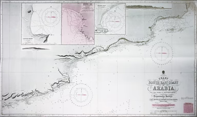
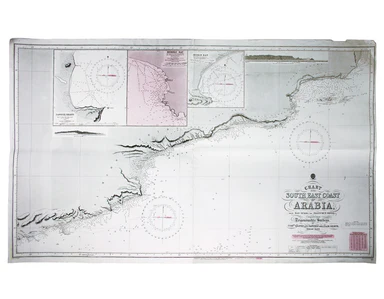
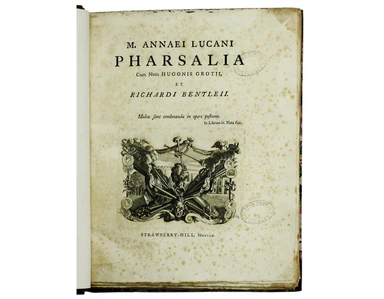
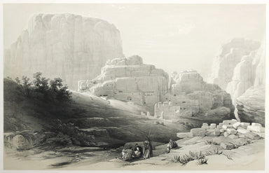
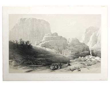
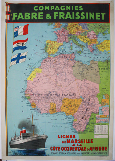
Acropolis, Lower End of the Valley of Petra
London: Day & Son for FG Moon, 1842-45. Tinted lithograph by Louis Haghe after Roberts, 33.5 x 53 cm, slight marginal waterstaining. From the ...
View full details
London: Day & Son for FG Moon, 1842-45. Tinted lithograph by Louis Haghe after Roberts, 33.5 x 53 cm, slight marginal waterstaining. From the ...
View full details
Chart of the South East Coast of Arabia from Ras Sukra to Palinurus Shoal, compiled from trigonometric Surveys First published in 1860 with correct...
View full details
This map of the environs of Edinburgh was published a decade before Ainslie’s landmark nine sheet map of Scotland. Originally published in 1778, th...
View full details
Arrian: [Greek title: Arrianou techne taktike, ektaxis kat Alanon... ] Ars Tactica, Acies Contra Alanos, Periplus Maris Erythraei, Liber De Venatio...
View full details
This map of the Mughal Empire is dedicated by the Blaeu brothers to Joan Huydecoper van Maarsseveen (1599–1661), a prosperous dealer in pelts and a...
View full details
G. Bradshaw’s Map of Canals, Navigable Rivers, Rail Roads etc. in the Southern Counties of England. From actual survey shewing heights of the ponds...
View full details
Picturesque antiquities of Scotland Adam de Cardonnel (1746/7-1820) trained as a surgeon, but ‘his easy circumstances left him leisure to indulge h...
View full details
Cary’s new map of England and Wales, with part of Scotland. On which are carefully laid down All the Direct and Principal Cross Roads the Course of...
View full details
This Central London Railway map is similar in style to the UERL common design which had been in circulation since 1908, although with a chocolate r...
View full details
This route map advertises passenger, postal and cargo steamship services between Marseille and West Africa. The SS Canada was built for the Fabre L...
View full details
La Savoia divisa nelle sue Principali Provincie da Giacomo Cantelli da Vignola [….] This is a map of Savoy from Mercurio Geografico, an unusual and...
View full details
Afbeeldinge van’t zeer vermaarde Eiland Geks-Kop This Dutch ‘fool’s cap’ map satirises the bursting of the financial bubbles of 1720. Cartographic ...
View full details
Tabula Prima Asiae continet Pontum, Bithyniam, Asiae propriae dictam, in qua Phyrgia Lyciam Pamphiliam, in qua Pisidia, Galatiam, in qua Paphlagoni...
View full details
Garbutt believed he had ‘rescued’ the London Underground map from the clutches of Harold Hutchison and his ‘ham-fisted parody’ of Beck’s designs. H...
View full details
Quintilian; Marcus Fabius Quintilianus: [Institutio Oratoria] [colophon: impressum Florentaie [Florence] opera & sumptu Philippi Iuntae …] 1515...
View full details
Map of India and Birmah This map of India and Burma features an inset location map with British possessions coloured red, next to a distance table...
View full details
Our map of the Americas was prepared for the Homann firm by Johann Matthias Hase, professor of mathematics in Wittenberg, on his stereographic hori...
View full details
Particulars, with Plans, Key Plan and Conditions of Sale of the Hoxton Estate The Hoxton estate passed by marriage from the Pitfield to the Sturt f...
View full details
A dictionary of the English language: in which the words are deduced from their originals, explained in their different meanings, … Abstracted from...
View full details
Johnson’s last great work contains a great deal of anecdotal information which might otherwise have been lost. It was first published as ‘Prefaces,...
View full details
Survey of the country around London to the distance of thirty two miles from St Paul’s The map extends between Ware and Chatham, Bray and Dorking. ...
View full details
Carte de la Mer d’Ecosse, Contenant les Isles et Costes Septentrionales et Occidentales d’Ecosse et les Costes Septentrionales d’Irlande This detai...
View full details
This map of Malaya has an inset regional map locating Malaya in the context of ‘adjacent terrritories’. A previous owner of this, map Lieutenant D...
View full details
[Greek title: Markou Antoninou autokratoros ton eis heauton biblia 12] Marci Antonini Imperatoris eorum quae ad seipsum libri XII… Glasguae [Glasgo...
View full details
This plan of Florence was published by Merian and his heirs in various works, including the Itinerarium Italiae of 1640 and editions of the Theatru...
View full details
Terrae Yemen maxima Pars seu Imperii Imami, Principatus Kaukebân, nec non ditionum Haschid u Bekîl, Nehhm, Chaulân, Abu Arîsch Et Aden, Tabula ex o...
View full details
Aeneas of Gaza; Zacharias, Bishop of Mytilene: De immortalitate animae, et mortalitate universi, ex recensione et cum animadversionibus Casparis Ba...
View full details
Pianta del Nuovo Aquedotto che conduce l’acqua a Civita Vechia fabricato in parte sopra le ruuine dell’ antico construtto da Traiano Imperatore Thi...
View full details
An Historical Sketch of the Campaign of 1815, illustrated by plans of the operations and of the battles of Quatre Bras, Ligny, and Waterloo... seco...
View full details
District within ¼ mile radius [of] Monument Stanford’s was a firm of map publishers as well as map retailers until after the Second World War, with...
View full details
Archipel des Indes Orientales, qui comprend les Isles de la Sonde, Moluques et Philippines, tirées des Cartes du Neptune Oriental This map of Indon...
View full details
This map of Tehran features a legend in the borders listing 218 places of interest in the pre-Revolutionary city. The mapmaker’s own premises are i...
View full details
This map of Dorset was published in Philip Lea’s edition of Christopher Saxton’s county atlas, commonly known as the Lea-Saxton or Saxton-Lea. Chr...
View full details
The Stars in Six Maps, on the the Gnomonic Projection, revised by the Rev. WR Dawes These star charts show allegorical images of the various conste...
View full details
The May 1925 issue of Stingemore’s passenger map shows Wembley Exhibition Grounds, and its covers advertise the number of escalators and other amen...
View full details
The Bending of the Bow A Version of the Closing Books of Homer’s Odyssey. Condition & Materials 4to. Number 15 of 75 copies signed by Neil...
View full details
Lucan: [...] Pharsalia, cum notis Hugonis Grotii, et Richardi Bentleii. [Twickenham] Strawberry-Hill 1760 The only classical text and "most disting...
View full details
A handsome example of the best and most beautiful – according to Brunet – edition of Spenser’s works. The Reverend Henry Todd’s ‘Poetical Works of ...
View full details
Chorographia Terrae Sanctae in angustiorem formam redacta, et ex variis auctoribus a multibus erroribus expurgata This map of the Holy Land, after ...
View full details
Terra Sancta, sive Promissionis, olim Palestina recens delineata, et in lucem edita per Nicolaum Visscher… Visscher’s influential map of the Holy L...
View full details
A New Geographical Pastime: Walker’s Tour through England and Wales Most games of this nature were educational, and in this case players learn as t...
View full details
A New Geographical Pastime The elder John Wallis (c. 1745-1818) recovered from bankruptcy to become one of the major publishers of children’s games...
View full details
Anthony Wood, who sometimes chose to style himself “à Wood”, is described as “a very strong lusty man, of uncouth manners and appearance ... not av...
View full details
Map of India, constructed with great care and research from all the Latest Authorities and intended more particularly to facilitate a reference to ...
View full details