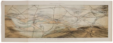
Ainslie's Environs of Edinburgh
This map of the environs of Edinburgh was published a decade before Ainslie’s landmark nine sheet map of Scotland. Originally published in 1778, th...
View full details
This map of the environs of Edinburgh was published a decade before Ainslie’s landmark nine sheet map of Scotland. Originally published in 1778, th...
View full details
Though credited on the title-page under his pen-name ‘Aleph’, William Harvey himself gives all the credit for this series of comic maps to a “young...
View full details
Though credited on the title-page under his pen-name ‘Aleph’, William Harvey himself gives all the credit for this series of comic maps to a “young...
View full details
Thus anthropomorphic map of Holland and Belgium was published in “Geographical Fun: Being Humorous Outlines of Various Countries.”. Though credited...
View full details
This anthropomorphic map of Ireland was published in “Geographical Fun: Being Humorous Outlines of Various Countries”. Though credited on the title...
View full details
This anthropomorphic map depicting Wales as "Owen Glendowr, in Bardic grandeur" is from 'Geographical Fun: Being Humorous Outlines of Various Count...
View full details
This is a separately issued example of a map of Ireland which also appeared in Arrowsmith’s major work, his influential ‘London Atlas of Universal ...
View full details
Bacon’s Map of the World on Mercator’s Projection Condition & MaterialsLithographed folding map, sheet size 48 x 66 cm. Original hand colour, a...
View full details
Map of China, Japan and Korea. / [Cover title:] The Eastern Crisis. Bacon's large-scale map of Japan, Korea, China, Manchuria Produced to illustrat...
View full details
This issue of Beck’s 1934 map saw a slight increase in size of the card folder given away to passengers. Beck’s diagram is one of the most innovat...
View full details
Beck’s 1938 passenger map features on its reverse an enlargement of the central London area with interchange stations named inside large diamonds. ...
View full details
Map of the River Thames, shewing locks, bridges, adjacent roads & railways, drawn expressly for the Rowing Almanack & Oarsman’s Companion T...
View full details
The Central London Railway pioneered giving maps like this one to passengers free of charge, something which we now take for granted but which only...
View full details
The Daily Mail Special Map Of The Far East Produced to illustrate the Russo-Japanese War, this map indicates Treaty Ports, dockyards and naval base...
View full details
The Daily Telegraph was one of a number of newspapers to sponsor London underground maps, like our example from 1919 which also includes the tramwa...
View full details
Map of India and Birmah This map of India and Burma features an inset location map with British possessions coloured red, next to a distance table...
View full details
London, the Bastion of Liberty On returning to Blandford Studio in 1946 after his war service with the Air Ministry, Kerry Lee spent six months wor...
View full details
Underground map of London with some motor bus connections, September 1916 issue. The London General Omnibus Company was by this point owned by the ...
View full details
The “District Railway” Miniature Map of London and Environs (6th edition) District Railway routes are overprinted in red on this road and rail map ...
View full details
The British Empire Exhibition was, at the time, the largest exhibition staged anywhere in the world; a high profile, postwar statement of confidenc...
View full details
This is the Summer 1928 issue of this portrait format map of the London underground, issued 1928-29. The style of the lines, stations and intercha...
View full details
Souvenir Map of the Coronation procession May 12th, 1937. This decorated Map is drawn to mark the Royal Procession of Their Majesties Coronation......
View full details
This plan of the Manchester Shipping Canal was published as a supplement to ‘The Illustrated London News’, February 3rd 1883. Construction began in...
View full details
The Railway Clearing House allocated revenue on occasions where one company’s train ran over another’s track, and promoted standardisation (of ever...
View full details
This map of Middlesex was published in Reuben Ramble's ‘Travels through the Counties of England’, an uncommon county atlas for children. Reuben Ram...
View full details
Sketch Map of Northern and Central East Africa / [Cover title:] Road Map of East Africa This map was ‘compiled with the help of the Public Works an...
View full details
This map of Calcutta includes inset views of the Writers’ Buildings, Government House and Esplanade Row. Calcutta expanded rapidly under the Gover...
View full details
This map of Dublin was engraved by Edmund Turrell after William Barnard Clarke for The Society for the Diffusion of Useful Knowledge. The SDUK was ...
View full details
Smith's New Map of England and Wales, with part of Scotland including the turnpike and principal cross roads, the course of the rivers and navigabl...
View full details
Huntington, both shire and shire towne with the ancient citie Ely described This is an unusual example of John Speed’s map of Huntingdonshire – it ...
View full details
Stanford’s map of London and the twelve miles round was published in various editions between (at least) 1860 and 1903. Condition & MaterialsLi...
View full details
This is the North Eastern sheet of Stanford’s Library Map, extending as far east as Straford and West Ham; further sheets were available to extend ...
View full details
Also published in Stanford’s London Atlas, our example of this map of Africa was separately issued and illustrates the speed and scale of the Scram...
View full details
The May 1925 issue of Stingemore’s passenger map shows Wembley Exhibition Grounds, and its covers advertise the number of escalators and other amen...
View full details
Our map of the London underground is the second edition in a series designed by Fred Stingemore, issued free to passengers from May 1925 onwards an...
View full details
This map of Central America was engraved by John Rapkin for John Tallis' popular ‘Illustrated Atlas’. It includes black and white vignettes of Beli...
View full details
This map of Jamaica includes vignettes of Kingston, Port Royal, Port Antonio, and a sugar mill. The map was engraved by John Rapkin for John Tallis...
View full details
This map of Nova Scotia was engraved by John Rapkin for John Tallis' popular ‘Illustrated Atlas’; it includes black and white vignettes of Halifax,...
View full details
The map of the Eastern Hemisphere tracks the overland route to India (subject of a separate map in the series) and on to Australia. John Tallis the...
View full details
Victoria or Port Phillip Engraved by John Rapkin for the Illustrated Atlas, this map includes vignettes of Melbourne, the River Glenelg, a kangaroo...
View full details
This map of South Africa was published by The Times during the Second Anglo-Boer War, for the benefit of members of the British public following th...
View full details
Wallis's Guide for Strangers, through London, and its Evirons, 1821 The stranger will here find an alphabetical list of streets corresponding to a ...
View full details
Britannia sits in the central panel of this cartographic board game, contemplating possibilities for commerce and the arts opened up by the new rai...
View full details
Map of India, constructed with great care and research from all the Latest Authorities and intended more particularly to facilitate a reference to ...
View full details
Wyld’s map of the Theatre of War in the Baltic and Black Seas including the whole of Russia & Turkey and the Mediterranean Sea This map was ...
View full details