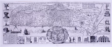
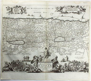
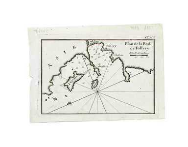
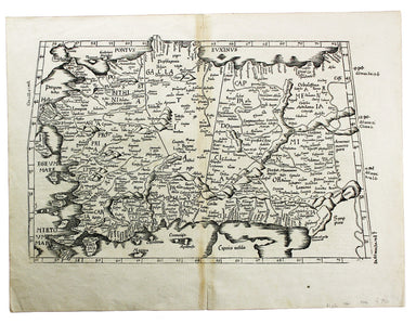
Tirinus' Map of the Holy Land
Chorographia Terrae Sanctae in angustiorem formam redacta, et ex variis auctoribus a multibus erroribus expurgata This map of the Holy Land, after ...
View full details
Chorographia Terrae Sanctae in angustiorem formam redacta, et ex variis auctoribus a multibus erroribus expurgata This map of the Holy Land, after ...
View full details
Carte de la Coste d’Arabie, Mer Rouge, et Golfe de Perse. A map of the Arabian peninsula. Jacques Nicolas Bellin the elder (1703-1772) was first ch...
View full details
Carte de L’Arabie, du Golfe Persique et de la Mer Rouge, avec L’Egypte, La Nubie et L’Abissinie This map of Arabia was published in an Italian edit...
View full details
Het Beloofde Landt Canaan door wandelt van onfen Salichmaeker Iesu Christo, nessens syne Apostelen Oriented to the west, this map of the Holy Land ...
View full details
This view of Constantinople isfrom Mallet’s Description de l’Univers, first published in Paris in 1683 and reprinted with German text in Frankfurt ...
View full details
This plan of Constantinople is from Mallet’s Description de l’Univers, first published in Paris in 1683 and reprinted with German text in Frankfurt...
View full details
Constantinopoli / Descrittione di Constantinopoli First published in 1572, our example of Porcacchi’s map of Constantinople is from the second edit...
View full details
This map of Ancient Jerusalem is from Mallet’s Description de l’Univers, first published in Paris in 1683 and reprinted with German text in Frankfu...
View full details
This sea chart shows the environs of Marmara Island on the southern coast of the Sea of Marmara, Turkey. The practical pocket sea atlas by Marseill...
View full details
A sea chart of Foça, Turkey; near Smyrna. The practical pocket sea atlas by Marseilles hydrographer Joseph Roux, charting the ports and harbours of...
View full details
Condition & Materials Copper engraving, 52.5 x 26.5 cm; a chart of the Caspian Sea after Jean Baptiste Bourguignon d'Anville, black and white, ...
View full details
Tabula Prima Asiae continet Pontum, Bithyniam, Asiae propriae dictam, in qua Phyrgia Lyciam Pamphiliam, in qua Pisidia, Galatiam, in qua Paphlagoni...
View full details
In the margin to the left of this map is an incomplete list of sultans of the Ottoman Empire. The map was published in Wagner’s ‘Delineatio Provinc...
View full details
Mer Méditerranée – Port de Smyrne This French naval chart of Smyrna includes insets of Port d’Abri (the inner harbour at modern day Izmir) and two ...
View full details
Indsicher Ozean – Golf von Aden – Ansteuerung von Aden This German naval chart of Aden shows breakwaters and lights highlighted in colour. It detai...
View full details