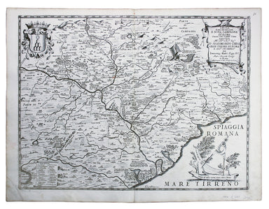
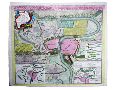
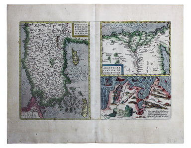
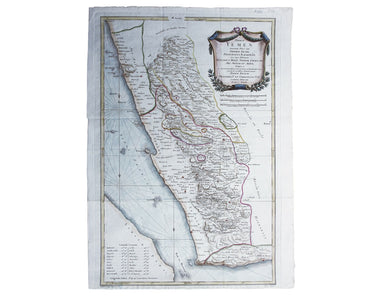
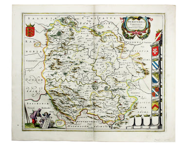
De Rossi’s Map of Campagna Romana
Tavola Esatta dell’antico Latio e Nova Campagna di Roma, situata sotto il quinto Clima […] Prepared by papal cartographer Innocenzo Mattaei circa 1...
View full details
Tavola Esatta dell’antico Latio e Nova Campagna di Roma, situata sotto il quinto Clima […] Prepared by papal cartographer Innocenzo Mattaei circa 1...
View full details
Carte Routière de la France dressée par ordre de Monsieur le Directeur Général des Ponts et Chaussées Though described in the title as a road map o...
View full details
Cheffins’s Map of the English & Scotch Railways Cheffins’s Map of the Railways in England & Scotland, accurately delineating all the lines ...
View full details
Kreigs Expeditions Karte in Bohmen I Blat, in welchern die Haubstadt Prag mit der Franzofsischen und Saechsischen Belegerug und Eroberung, so den 2...
View full details
Mer Méditerranée – Port de Smyrne This French naval chart of Smyrna includes insets of Port d’Abri (the inner harbour at modern day Izmir) and two ...
View full details
The Stars in Six Maps, on the the Gnomonic Projection, revised by the Rev. WR Dawes These star charts show allegorical images of the various conste...
View full details
Natoliae quae olim Asia Minor nova descriptio / Aegypti recentior descriptio / Carthaginis celeberrimi sinus typus Here on one sheet we have three ...
View full details
Preliminary Chart – West Indies – Barbados This chart of Barbados shows sands and soundings etc, with interior detail of relief, roads and settleme...
View full details
Indsicher Ozean – Golf von Aden – Ansteuerung von Aden This German naval chart of Aden shows breakwaters and lights highlighted in colour. It detai...
View full details
Blaeu and the rival Golden Age Dutch cartographic publishing house of Janssonius raced to bring out atlases of the British Isles in the 1630s and e...
View full details
Chart of the South East Coast of Arabia from Ras Sukra to Palinurus Shoal, compiled from trigonometric Surveys First published in 1860 with correct...
View full details
Terrae Yemen maxima Pars seu Imperii Imami, Principatus Kaukebân, nec non ditionum Haschid u Bekîl, Nehhm, Chaulân, Abu Arîsch Et Aden, Tabula ex o...
View full details
Daciarum, Moesiarumque, vetus descriptio This map of Ancient Dacia and Moesia, modern Romania and Bulgaria on the Black Sea was published by Baltha...
View full details
This intricate anthropomorphic map (the artist also produced a zoomorphic companion piece) was issued soon after the outbreak of the First World Wa...
View full details
Bacon’s Large Scale Plan of the City of London –Bacon’s Coloured Plan of the City of London… “Blitzed” areas shown A highly detailed map of London ...
View full details
Proctor, Robert: Narrative of a journey across the Cordillera of the Andes and of a residence in Lima and other parts of Peru in the years 1823 and...
View full details
Hesiod: Hesiodo Ascraei poetae vetustissimi ac sapientissimi opera, quae quidem extant, omnia Graecè, cum interpretatione latina è regione, ut conf...
View full details
Arnobius: Adversus Gentes Libri VII. Cum Recensione Viri Celeberrimi, & integris omnium commentariis. Editio novissima atque omnium accuratissi...
View full details
This map of Burma was published in the second trade edition of Stanford’s London Atlas. Edward Stanford (senior) acquired Arrowmsith's stock in 187...
View full details
This map attempts full integration of bus and coach routes, tramways, the Underground and main-line railways, and is possibly the first issue showi...
View full details
In 1933 the Met became part of the LPTB. Here though, the Tube and other railways fade into the background. The emphasis is on work/life balance, c...
View full details
This map of Reading is from Hermannides' Magna Britannia. Nearly all of the plans are based on the small inset plans shown on John Speed's county m...
View full details
Maximus of Tyre: [Greek title] Sermones sive Disputationes XLI. Graece nunc primum editae. [Geneva]: ex officina Henrici Stephani Parisiensis typog...
View full details
Oppian: [Greek title:] Alieutikwn biblia pente... Kynhgetikwn biblia tessara. Oppiani de piscibus libri V. Eiusdem de venatione libri IIII. Oppiani...
View full details
Diogenes Laertius; Eunapius of Sardis: [...] De Vitis, dogm. & apophth. clarorum philosophorum, Libri X. Heschyii ill. de iisdem philos. & ...
View full details
Aeneas of Gaza; Zacharias, Bishop of Mytilene: De immortalitate animae, et mortalitate universi, ex recensione et cum animadversionibus Casparis Ba...
View full details
Blaeu’s map of Herefordshire. Blaeu and the rival Golden Age Dutch cartographic publishing house of Janssonius raced to bring out atlases of the Br...
View full details
The Bay of Gibraltar. With a plan of the Town, Rocks and Fortifications of Gibraltar as they now are. Also a plan of Algezira… Copied from the Drau...
View full details
Trans-Isula D. Condition & Materials Copper engraving, 9.5 x 13.4 cm, recent hand-colour, Latin text on verso; map of Overjissel.
The Seven United Provinces This map of the Netherlands was prepared for Playfair’s New General Atlas. Condition & Materials Copper engraving, ...
View full details
This map of Poland is from Mallet’s Description de l’Univers. Condition & Materials Copper engraving, 14.5 x 10.5 cm, recent hand-colour, Fren...
View full details
This plan of Tienen in Flanders is from the Civitates Orbis Terrarum, one of the most significant cartographic works of the late sixteenth-century,...
View full details
Plan du Dock ou du Bassin ‡ flot ‡ Londres dit Katarinen Dock ou Dock St. Katharine. Condition & Materials Lithograph, 35 x 40.5 cm, black and ...
View full details
Mappa Totius Mundi adornata juxta Observationes dnn. Academiae Regalis Scientiarum et nonnullorum aliorum secundum annotationes recentissimas edita...
View full details
Afbeeldinge van’t zeer vermaarde Eiland Geks-Kop This Dutch ‘fool’s cap’ map satirises the bursting of the financial bubbles of 1720. Cartographic ...
View full details
Signed limited edition screenprint Colour screenprint, sheet size 78 x 57.5 cms, signed by the artist and inscribed 'AP' (Artist’s Proof) in pencil...
View full details
Topographia Repraesentio Barbarici Portus et Urbis Munitae Oran … Oran, an important trading port and now Algeria’s second city, was governed by th...
View full details
Lucan: [...] Pharsalia, cum notis Hugonis Grotii, et Richardi Bentleii. [Twickenham] Strawberry-Hill 1760 The only classical text and "most disting...
View full details
An illustrated record of important events in the annals of Europe, during the last four years: comprising a series of views of the principal place...
View full details
“Hell on Wheels” War Against the Axis 1942 – 1943 – 1944 The lower panel of this map deals with operations in North Africa and Sicily, with the uni...
View full details
First published in 1914, this revised edition highlights administrative boundaries. Though technically administered jointly by Egypt and Britain be...
View full details
[Greek title: Demosthenous logoi, kai prooimia demegorika, kai epistolai: syn tais exegesesin ophelimotatais, tou Oulpianou rhetoros, te ton palaio...
View full details
This map of Frankfurt, view of the city at the foot of the map, was published by the SDUK. The Society for the Diffusion of Useful Knowledge was fo...
View full details
Ceretica sive Cardiganensis Comitatus; Anglis Cardigan Shire Blaeu and the rival Golden Age Dutch cartographic publishing house of Janssonius raced...
View full details
Busca, near Cuneo in Piedmont. Blaeu’s townbook of Savoy and Piedmont was first published by the Blaeu heirs in 1682, but the plates were purchased...
View full details
Presentation copy inscribed to Edmund Grosse. The Brotherton Library in Leeds possesses another copy, inscribed "From the author", and with Gosse's...
View full details