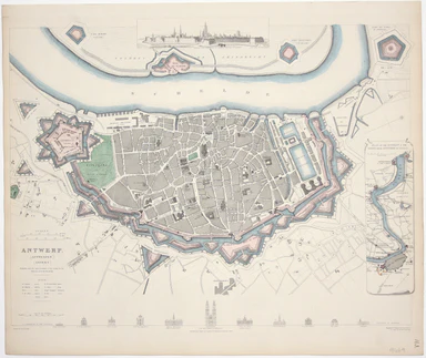
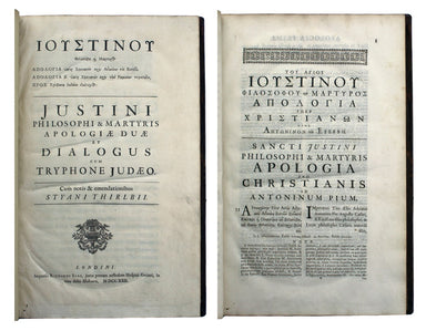
Robert de Vaugondy’s Map of Spain & Portugal, Showing Roads
Carte des Royaumes d’Espagne et de Portugal dans laquelle sont tracées les routes de postes This is a later state of Robert de Vaugondy’s road map ...
View full detailsCarte des Royaumes d’Espagne et de Portugal dans laquelle sont tracées les routes de postes This is a later state of Robert de Vaugondy’s road map ...
View full detailsWest Indies – Tobago – Scarborough – Rockly Bay This chart of Rockly Bay shows soundings etc, with interior detail of relief, roads and settlements...
View full detailsThis chart of Jamaica shows soundings etc, with interior detail of relief, roads and settlements, and an inset of Morant Cays. First published in 1...
View full detailsAntilles – Ile de la Grenade This detailed chart of Grenada was derived from British Admiralty surveys. Condition & Materials French naval char...
View full detailsAntilles – Ile de Culebra ou du Passage This detailed chart of Isla Culebra (now an island-municipality of Puerto Rico) was derived from British Ad...
View full detailsMap of the Grand Junction Railway and its Adjacent Country. [Copied by permission from the Company’s official map.] Shewing all the the stations on...
View full detailsThis map of Liddesdale, in the Scottish borders, is from Golden Age Dutch cartographer Blaeu’s Scottish atlas. First published in 1654, the atlas w...
View full detailsA new gradually encreasing Compass-Map of part of the Sea Coasts of England, in which is contained the Coasts of Sussex, extending from Eastwards o...
View full detailsThis map of Glasgow is one of the town plans published in Tallis’ hugely popular ‘Illustrated Atlas’ which was published serially from the mid 1840...
View full detailsThis map of Edinburgh is one of the town plans in Tallis’ hugely popular ‘Illustrated Atlas’ which was published serially from the mid 1840s onward...
View full detailsA New Geographical Pastime: Walker’s Tour through England and Wales Most games of this nature were educational, and in this case players learn as t...
View full detailsHistorical pastime, or, a new game of the history of England from the Conquest to the accession of George the Third This popular early nineteenth-c...
View full detailsG. Bradshaw’s Map of Canals, Navigable Rivers, Rail Roads etc. in the Southern Counties of England. From actual survey shewing heights of the ponds...
View full detailsThis bird’s-eye view of the Suez Canal was published as a ‘Special Supplement’ of The Graphic (a weekly illustrated newspaper), issued on 2 Septemb...
View full detailsNieuwe Kaarte van der XVII Nederlandsche Provincien: waar in aangewezen worden de landen door den Koning van Vrankryk geconquesteerd als mede die v...
View full detailsThis is a collection of 61 intelligence handbooks, 1943-1945, covering enemy and occupied countries and compiled by the Foreign Office and Ministry...
View full detailsIn the 1920s Valletta was the location of the Royal Navy's Mediterranean Fleet's headquarters. Prepared on the island, this map of Malta has a grid...
View full detailsCarte de L’Arabie, du Golfe Persique et de la Mer Rouge, avec L’Egypte, La Nubie et L’Abissinie This map of Arabia was published in an Italian edit...
View full detailsThis pictorial map of Liverpool is folded into a souvenir record-sleeve style pack which comprises: ‘Nothing to get hung up about’, a 30 page shor...
View full detailsA New Geographical Pastime The elder John Wallis (c. 1745-1818) recovered from bankruptcy to become one of the major publishers of children’s games...
View full details[Map of] Afghanistan, political, phisical [sic], roads and distances, important historical sites According to the online resource Encyclopaedia Ira...
View full detailsBlaeu and the rival Golden Age Dutch cartographic publishing house of Janssonius raced to bring out atlases of the British Isles in the 1630s and e...
View full detailsThe framing device used by this children’s atlas is a little dark: Filip and his sister Cora are orphans, living with their aunt and uncle and cous...
View full detailsBradshaw’s Railway Companion, containing the times of departure, fares &c., of the railways in England, and also hackney coach fares from the p...
View full details[Both title-pages in Greek and Latin] Pausaniæ Accurata Graeciae descriptio, qua lector ceu manu per eam regionem circumducitur… [bound with] Arist...
View full details[Title in Greek and Latin] Stephani Byzantini Gentilia per epitomen, antehac… De urbibus inscripta [with] Notae et castigationes postumae in Stepha...
View full detailsMary Sims and Mary Camidge, both signing as 'of Maps and Guides, Ltd', each produced posters for British Railways (Eastern Region) in 1960. They th...
View full detailsMap of the Great Western Railway and Connections This map illustrates how the Great Western Railway connected resources such as coal fields, china ...
View full detailsCarte de Royaume d’Angleterre dressé par Hérisson, elêve du Sr. Bonne, ancien Ingénieur Hydrographe de la Marine Eustache Hérisson (1759-1816) was ...
View full detailsThe map shows bus, tram and train services operated by the Underground Group and is very similar to the pocket map issued in guidebooks c.1924 (ill...
View full detailsThis pictorial map grouping the three counties northeast of London was published by British Railways (Eastern Region) to promote leisure travel jus...
View full detailsStanford’s New Map of the County of London on the Scale of Four Inches to One Mile This new edition of Stanford’s map was advertised in a variety o...
View full detailsLes Vignobles de France – Vins de Champagne Government and national wine trade bodies sponsored Louis Larmat’s regional wine atlases in the 1940s a...
View full detailsPlot, Robert: The natural history of Oxford-shire, being an essay toward the natural history of England. By R.P. LL.D. Oxford: Printed at the Theat...
View full detailsThucydides: [Greek title] De bello Peloponnesiaco libri octo. Iidem Latine, ex interpretatione Lavrentii Vallae, ab Henrico Stephano recognita […] ...
View full detailsThis is a map of the Italian island of Sardinia, oriented with north to the left of the map. Condition & Materials Copper engraving, sheet size...
View full details[Title-page] Atlas Novus This title-page shows Europe, seated, accepting tribute from the other continents: Asia, Africa and America. In the foregr...
View full detailsThis view shows the major eruption of Vesuvius in December 1631, published by Merian and his heirs in various works, including the Itinerarium Ital...
View full detailsThis is a view of the Solfatara volcanic crater, mythological home of Vulcan in the Phlegraean Fields at Pozzuoli, near Naples. It was published by...
View full detailsThis plan of of Ostia was published by Merian and his heirs in various works, including the Itinerarium Italiae of 1640, the Archontologia cosmica ...
View full detailsThis plan of Piacenza was published by Merian and his heirs in various works, including the Itinerarium Italiae of 1640, the Archontologia cosmica ...
View full detailsThis map of Baden in Switzerland was published by Merian and his heirs in various works, including the Archontologia cosmica, Theatrum Europaeum an...
View full detailsThis map of Stade was published by Merian and his heirs in various works, including the Theatrum Europaeum. Condition & Materials Copper engrav...
View full detailsThis map of Wismar was published by Merian and his heirs in various works, including the Theatrum Europaeum. Condition & Materials Copper engr...
View full detailsThis map of Aachen, or Aix-la-Chapelle, was published by Merian and his heirs in various works, including the Theatrum Europaeum. Condition & M...
View full detailsThis plan of Mantua was published by Merian and his heirs in various works, including the Itinerarium Italiae of 1640 and editions of the Theatrum ...
View full detailsThis plan of Genoa was published by Merian and his heirs in various works, including the Itinerarium Italiae of 1640 and editions of the Theatrum E...
View full detailsThis plan of Palmanova (a Venetian town founded in 1593, sheltered behind innovative fortifications taking the form of a nine-pointed star) was pub...
View full details