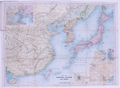
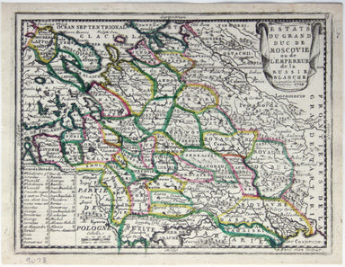
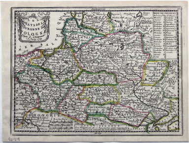
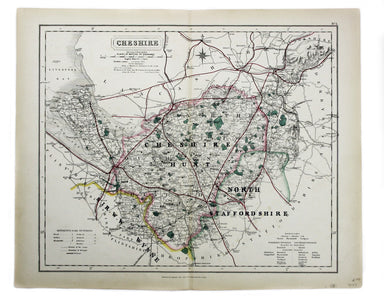
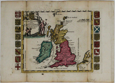
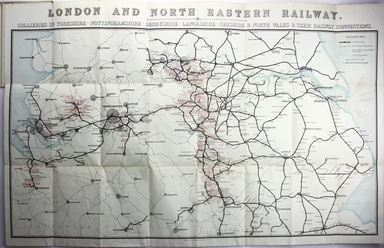
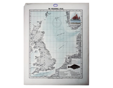
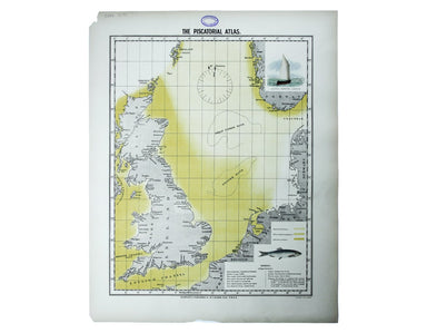
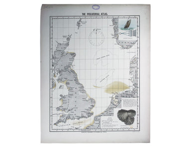
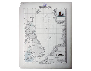
Bacon's Russo-Japanese War Map
Map of China, Japan and Korea. / [Cover title:] The Eastern Crisis. Bacon's large-scale map of Japan, Korea, China, Manchuria Produced to illustrat...
View full details
Map of China, Japan and Korea. / [Cover title:] The Eastern Crisis. Bacon's large-scale map of Japan, Korea, China, Manchuria Produced to illustrat...
View full details
This map of Middlesex was engraved by Toms for Thomas Badeslade’s ‘Chorographia Britanniae’, an attractive pocket atlas which according to Badeslad...
View full details
Carta ilustrada del Muy Noble y Muy Leal Señorio de Vizcaya This map was published to mark the centenary of the Banco de Bilbao, one of the big fou...
View full details
This was the first official London Underground passenger map to be printed since spring 1943, at least partly due to paper shortages. When printed ...
View full details
Karte von der Insel St Lucia This map of the Caribbean island of St Lucia was published in the Dutch edition of Prévost's Histoire Générale des Voy...
View full details
Blome published the first new series of county maps in the sixty years since the appearance of John Speed’s ‘Theatre’. In the straightened financia...
View full details
This characteristically clear and elegant map of Herefordshire is by John Cary, one of the leading cartographic engravers, publishers and globe-mak...
View full details
Cheffins’s Map of the English & Scotch Railways Cheffins’s Map of the Railways in England & Scotland, accurately delineating all the lines ...
View full details
Le Royaume de Hongrie, ou se trouvent la Transilvanie, la Moldavie, la Valaquie, la Bosnie la Servie et la Bulgarie, &c Our map of Hungary and ...
View full details
Estats du Grand Duc de Moscovie ou de l’Empereur de la Russie Blanche This map of Muscovy, or European Russia, was published in Chiquet’s ‘Le nouve...
View full details
Les estats de la Couronne de Pologne This map of the Crown of the Kingdom of Poland was published in Chiquet’s ‘Le nouveau et curieux atlas géograp...
View full details
Les Royaumes de Portugal et d’Algarve This map of Portugal was published in Chiquet’s ‘Le nouveau et curieux atlas géographique et historique ...’....
View full details
This map shows the Swedish Empire, including Finland and Swedish Livonia. It waspublished in Chiquet’s ‘Le nouveau et curieux atlas géographique et...
View full details
Le XVII Provinces des Pays Bas divisées en Provinces Unies connues sous le nom de Hollande, et en Pays Bas Catholiques connues sous le nom de Fland...
View full details
Collins’ Chart of the Black Sea/Collins’ New Map of the Black Sea, shewing all the fortifications &c on an extended scale. Contemporary with th...
View full details
This is one of the most detailed mid-19th Century American atlas maps of Cuba and the region, set within Colton’s distinctive style of border, by o...
View full details
Cruchley’s Improved Geographical Companion throughout England & Wales including part of Scotland In this map of England and Wales, we have an i...
View full details
France divided into Metropolitan Circles and Departments This map was engraved by Samuel John Neele for the atlas volume to Cruttwell’s Gazeteer, p...
View full details
This map of Poland was engraved by Samuel John Neele for the atlas volume to ‘Cruttwell’s Gazeteer’, published by G & JJ Robinson. Condition &a...
View full details
A Plain Map of the Central Part of Europe. According to the Method of the Abbé Gaultier by Mr Wauthier his Pupil This map of Central Europe is from...
View full details
This is the general title page for Blaeu’s town books of the Netherlands. The first volume features plans and views of the towns of the Northern p...
View full details
Map of the North West Circuit of the Principality of Wales, comprising the Counties of Anglesey, Caernarfon & Merioneth, from an Actual Survey…...
View full details
This map of Buckinghamshire was prepared for William Colling Hobson’s Fox-Hunting Atlas. It is overprinted with the names of the hunts and the plac...
View full details
This map of Cheshire wasprepared for William Colling Hobson’s Fox-Hunting Atlas. It is overprinted with the names of the hunts and the places of th...
View full details
A map of the French Alps, the Dauphiné, incuding Grenoble. The borders are those defined by the Treaty of Utrecht (1713) and the cartouche (putti m...
View full details
Alsatia Superior cum Suntgoia et Brisgoia The original Mercator Atlas (parts published from 1585 onwards) was not a commercial success; the copper ...
View full details
This map of the Baltic, with an inset of St Petersburg, is from the Royal Atlas of Modern Geography. Condition & Materials Lithographed map, 45...
View full details
The cartouche on this map of the British isles is surmounted by the old Stuart coat of arms and the borders are made up of sixteen regional armoria...
View full details
Condition & Materials Copper engraving, 21 x 25.5 cm, original hand-colour, on a folio leaf 37 x 29 cm, blank verso.
Ultimately derived from the SDUK but reflecting Haussman’s redevelopment of the city centre under Napoleon III, our example is from one of the last...
View full details
Départment de la Corse A map of Corsica from an edition of Levasseur’s ‘Atlas National Illustré’. Condition & Materials Steel engraving, engrav...
View full details
This is an LNER colliery map covering the midlands and north of England and Wales ('Collieries in Yorkshire, Nottinghamshire, Derbyshire, Lancashir...
View full details
Chine du nord - Corée - Manchoukouo Manchukuo – a Japanese term for Manchuria – was a puppet state of the Empire of Japan in China and Inner Mongol...
View full details
The “District Railway” Miniature Map of London and Environs (6th edition) District Railway routes are overprinted in red on this road and rail map ...
View full details
Originally published in the series ‘Twenty-Four Views in Hindostan’, a part-work issued 1802-1805 to illustrate Francis Blagdon’s ‘Brief History of...
View full details
Try Scotch Woodock, per The Ritz London Book of Afternoon Tea. For a pared-down version, simply spread hot buttered toast with Gentleman’s Relish a...
View full details
For a rainy day supper, put crab in your macaroni cheese. Trust me, you’ll love it This map was published in the ‘Piscatorial Atlas of the North Se...
View full details
Do you prefer your flatfish with eyes to the right, or to the left? This map was published in the ‘Piscatorial Atlas of the North Sea, English and ...
View full details
They’re bonnie fish and halesome farin’ This map was published in the ‘Piscatorial Atlas of the North Sea, English and George’s Channels’, a series...
View full details
O Oysters, come and walk with us! This map was published in the ‘Piscatorial Atlas of the North Sea, English and George’s Channels’, a series of 50...
View full details
Pilchards are either sardines, herring, or neither. I think it depends where you (and they) are from. This map was published in the ‘Piscatorial At...
View full details
Waiter, bring me shad roe... This map was published in the ‘Piscatorial Atlas of the North Sea, English and George’s Channels’, a series of 50 lavi...
View full details
Meunière your skate wings, or get someone else to do it for you This map was published in the ‘Piscatorial Atlas of the North Sea, English and Geor...
View full details
See the east coast Fishwife with her creel This map was published in the ‘Piscatorial Atlas of the North Sea, English and George’s Channels’, a ser...
View full details
This map was published in the ‘Piscatorial Atlas of the North Sea, English and George’s Channels’, a series of 50 lavishly chromolithographed chart...
View full details
The Piscatorial Atlas was the product of a decade or more of reports and correspondence with British fishermen This map was published in the ‘Pisca...
View full details
The fish with a face only a mother could love This map was published in the ‘Piscatorial Atlas of the North Sea, English and George’s Channels’, a ...
View full details
Why is it proverbially assumed to be very easy to run a whelk stall? They look like hard work to me This map was published in the ‘Piscatorial Atla...
View full details