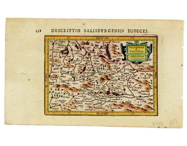
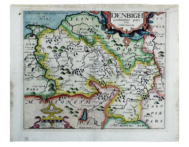
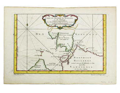
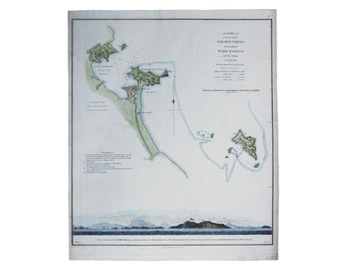
Map of Mechelen, from Rapin’s History
Mechelin, or Malines, the Capital of one of the ten Provinces of the Netherlands in Brabant This map of Mechelen was engraved by James Basire and p...
View full detailsMechelin, or Malines, the Capital of one of the ten Provinces of the Netherlands in Brabant This map of Mechelen was engraved by James Basire and p...
View full details
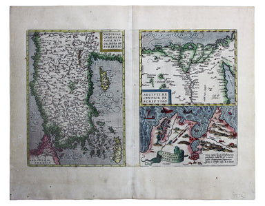
Carte du Dètriot de Waeigats, ou de Nassau This is map of the Yugorsky Strait in the Arctic Sea, separating Vaygach Island from the mainland. It il...
View full detailsThis map of Scandinavia is from Sebastian Münster's Cosmographia. A compendium of topographical information, folklore and travels, it was first pub...
View full detailsThis view of the Latvian capital Riga is fromfrom Sebastian Münster's Cosmographia. A compendium of topographical information, folklore and travels...
View full detailsCondition & Materials Copper engraving, 14.5 x 10.5 cm, recent hand-colour, French text on verso; a map of Muscovy from Mallet’s Description de...
View full detailsThis regional map of France is from Mallet’s Description de l’Univers. Condition & Materials Copper engraving, 15 x 10.5 cm, recent hand-colo...
View full detailsThis map of France is from Mallet’s Description de l’Univers. Condition & Materials Copper engraving, 15 x 10.5 cm, recent hand-colour, French...
View full detailsThis map of Moldavia and Transylvania is from Mallet’s Description de l’Univers. Condition & Materials Copper engraving, 15 x 11.5 cm, recent ...
View full detailsAllemagne en General This map of Northern Germany is from Mallet’s Description de l’Univers. Condition & Materials Copper engraving, 15.5 x 11....
View full detailsThis map of Hungary is from Mallet’s Description de l’Univers. Condition & Materials Copper engraving, 15 x 11.5 cm, recent hand-colour, Frenc...
View full detailsCercle de Baverie This map of Bavaria is from Mallet’s Description de l’Univers. Condition & Materials Copper engraving, 15 x 11.5 cm, recent h...
View full detailsThis map of the Netherlands is from Mallet’s Description de l’Univers. Condition & Materials Copper engraving, 15 x 10 cm, recent hand-colour, ...
View full detailsLes 13 Cantons Suisses et leurs Alliez This map of 13 Swiss Canton is from Mallet’s Description de l’Univers. Condition & Materials Copper engr...
View full detailsPartie de la Mer Glaciale, contenant la Nouvelle Zemble et le Pays de Samoiedes Condition & Materials Copper engraving, 23 x 36.5 cm, recent ha...
View full detailsHere's King Christian V, as he appears in Mallet’s ‘Description de l’Univers. Condition & Materials Copper engraving, 15 x 10.5 cm, recent han...
View full detailsHere are some lovely Swedes, from from Mallet’s ‘Description de l’Univers. Condition & Materials Copper engraving, 15 x 10.5 cm, recent hand-co...
View full detailsFrance/Paîs Bas This map of France and the Low Countries is from Mallet’s ‘Description de l’Univers. Condition & Materials Copper engraving, 15...
View full detailsThis map of France is from Mallet’s Description de l’Univers. Condition & Materials Copper engraving, 15 x 10.5 cm, recent hand-colour, light ...
View full detailsCondition & Materials Copper engraving, 23 x 32.5 cm, recent hand-colour, blank verso.
Condition & Materials Copper engraving, 23 x 32.5 cm, recent hand-colour, blank verso.
Condition & Materials Copper engraving, 9.5 x 13.4 cm, recent hand-colour, Latin text on verso; miniature map of Artois.
Condition & Materials Copper engraving, 9.5 x 13.4 cm, recent hand-colour, Latin text on verso; map of the Zijpe polder.
Veromandui This map of the modern Aisne is named here for the Viromandui, a Belgic tribal name. Condition & Materials Copper engraving, 9.5 x 1...
View full detailsCondition & Materials Copper engraving, 9.5 x 13.4 cm, recent hand-colour, Latin text on verso; map of Hainault.
Condition & Materials Copper engraving, 9.5 x 13.4 cm, recent hand-colour, Latin text on verso; map of Liège.
A miniature map of Salzburg and Carinthia. Condition & Materials Copper engraving, 10 x 13.5 cm, recent hand-colour, Latin text on verso;
This is Mercator's map of Pays Boulonnais and Guînes from the Atlas Minor. The original plates were engraved by Jodocus Hondius, but after these we...
View full detailsThis map of Southern Lorraine is from the Atlas Minor. The original plates were engraved by Jodocus Hondius, but after these were sold to the Londo...
View full detailsThis map of Northern Lorraine is from the Atlas Minor. The original plates were engraved by Jodocus Hondius, but after these were sold to the Londo...
View full detailsThis map of Anjou is from the Atlas Minor. The original plates were engraved by Jodocus Hondius, but after these were sold to the London trade in t...
View full detailsThis map of the province of Berry in central France is from the Atlas Minor. The original plates were engraved by Jodocus Hondius, but after these ...
View full detailsZara et Sebenic This map of Zara and Sebinico on the Croatian coast is from the second series of maps engraved for the Epitome by Philip Galle. Con...
View full detailsA Map of Great Greece and of the Islands of Sardinia and Corsica This map of the Greek colonies in southern Italy was published in An Universal His...
View full detailsThis plan of Madrid appeared in various works including Les Delices of I'Espagne et du Portugal and La galerie agrèable du monde. Condition & M...
View full detailsTurquie Septentrionale en Europe This map of the Northern Ottoman Territories is from Mallet’s Description de l’Univers. Condition & Materials ...
View full detailsCondition & Materials Copper engraving, 24.5 x 38 cm, recent hand-colour, blank verso; this map of Bologna is from Lalande’s Voyage en Italie, ...
View full detailsScarpanto (Karpathos) This map of Karpathos was engraved by Girolamo Porro and is set in descriptive Italian text with a woodcut headpiece and hist...
View full detailsMilo (Milos) This map of Milos was engraved by Girolamo Porro and is set in descriptive Italian text with a woodcut headpiece and historiated initi...
View full detailsNegroponte (Euboea) This map of Negropoonte was engraved by Girolamo Porro and is set in descriptive Italian text with a woodcut headpiece and hist...
View full detailsIl Sito de Curzolari (and Gulf of Lepanto) This map of the gulf of Lepanto was engraved by Girolamo Porro and is set in descriptive Italian text wi...
View full detailsCerigo (Kythera) This map of Kythera was engraved by Girolamo Porro and is set in descriptive Italian text with a woodcut headpiece and historiated...
View full detailsNicsia (Naxos) This map of Naxos was engraved by Girolamo Porro and is set in descriptive Italian text with a woodcut headpiece and historiated ini...
View full detailsMetellino (Mytilene, Lesbos) This map of Mitilini was engraved by Girolamo Porro and is set in descriptive Italian text with a woodcut headpiece an...
View full detailsBlome published the first new series of county maps in the sixty years since the appearance of John Speed’s ‘Theatre’. In the straightened financia...
View full detailsRobert Morden's maps were engraved to illustrate Gibson's edition of William Camden's Britannia, first published in 1695 and reprinted in various 1...
View full detailsWilliam Camden was an Elizabethan historian who wrote a county by county description of England. He continued to revise and expand his work, which ...
View full detailsRobert Morden's maps were engraved to illustrate Gibson's edition of William Camden's Britannia, first published in 1695 and reprinted in various 1...
View full details