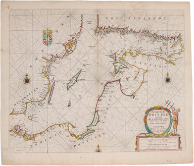
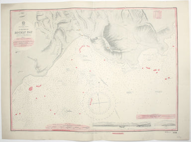
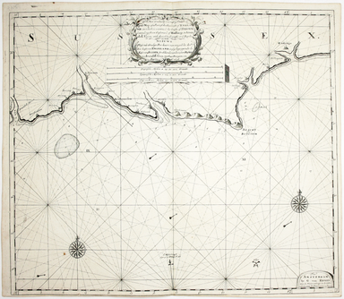
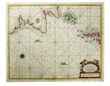
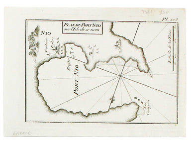
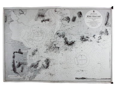
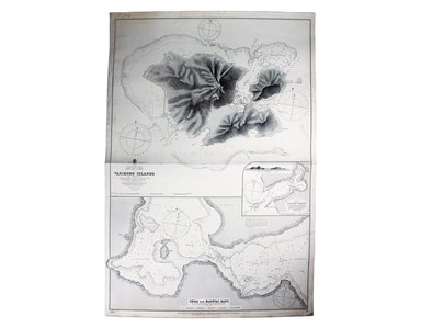
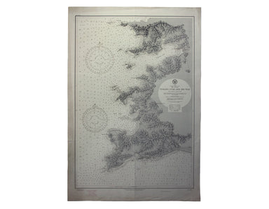
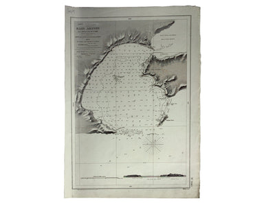
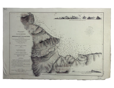
Blaeu's Chart of the Dorset Coast
De Custen van Engelandt tusschen de droochten van Weembrugh en Poortlandt This chart of part of the Dorset coast features woodcut coastal profiles ...
View full details
De Custen van Engelandt tusschen de droochten van Weembrugh en Poortlandt This chart of part of the Dorset coast features woodcut coastal profiles ...
View full details
Pas-Caart van de Oost Zee Verthoonende alle de Ghelegentheydt tusschen t'Eylandt Rugen ende Wyborg From one of the finest Dutch marine atlases of t...
View full details
Burma – Gulf of Mataban – Rangoon River and Approaches This chart covers the mouth of the river between Rangoon (Yangon) and the sea. It shows vill...
View full details
West Indies – Tobago – Scarborough – Rockly Bay This chart of Rockly Bay shows soundings etc, with interior detail of relief, roads and settlements...
View full details
This chart of Jamaica shows soundings etc, with interior detail of relief, roads and settlements, and an inset of Morant Cays. First published in 1...
View full details
Antilles – Ile de la Grenade This detailed chart of Grenada was derived from British Admiralty surveys. Condition & Materials French naval char...
View full details
Antilles – Ile de Culebra ou du Passage This detailed chart of Isla Culebra (now an island-municipality of Puerto Rico) was derived from British Ad...
View full details
A new gradually encreasing Compass-Map of part of the Sea Coasts of England, in which is contained the Coasts of Sussex, extending from Eastwards o...
View full details
Collins’ Chart of the Black Sea/Collins’ New Map of the Black Sea, shewing all the fortifications &c on an extended scale. Contemporary with th...
View full details
South America – British Guiana – Georgetown and mouths of Demerara and Essequibo Rivers This British chart of Georgetown shows soundings etc, with ...
View full details
This chart of Dublin bay shows soundings etc, with interior detail of relief and settlements (including eastern Dublin), and inset coastal profiles...
View full details
This British chart of Durban port was engraved by John and Charles Walker. It shows soundings etc, interior detail of relief and settlements includ...
View full details
South Pacific Ocean – Society Islands – Tahiti and Moorea (Otaheite and Eimeo) This chart was derived from French surveys of 1869 and 1885. The fir...
View full details
Faden, William: Le Petit Neptune Français; or, French Coasting Pilot, for the Coast of Flanders, Channel, Bay of Biscay, and Mediterranean. To whic...
View full details
Carte de l’entrée de la Tamise, avec les Bancs, Passes, Isles et Costes comprises entre Sandwich et Clay This is a revised version of a chart which...
View full details
The East Coast of Scotland with the Isles of Orkney and Shetland This sea chart is from ‘Great Britain’s Coasting Pilot’, the first English Sea Atl...
View full details
The practical pocket sea atlas by Marseilles hydrographer Joseph Roux, charting the ports and harbours of the Mediterranean, remained popular half ...
View full details
This sea chart shows the environs of Marmara Island on the southern coast of the Sea of Marmara, Turkey. The practical pocket sea atlas by Marseill...
View full details
A sea chart of Foça, Turkey; near Smyrna. The practical pocket sea atlas by Marseilles hydrographer Joseph Roux, charting the ports and harbours of...
View full details
Condition & Materials Copper engraving, 52.5 x 26.5 cm; a chart of the Caspian Sea after Jean Baptiste Bourguignon d'Anville, black and white, ...
View full details
Carte de la Mer d’Ecosse, Contenant les Isles et Costes Septentrionales et Occidentales d’Ecosse et les Costes Septentrionales d’Irlande This detai...
View full details
Carte des Isles du Cap-Verd This chart of the Cape Verde islands was engraved by Guillaume de la Haye. D’Après de Mannevillette (1707-1780) was a p...
View full details
Condition & Materials A chart of Sète in southern France, copper engraving, 14 x 20 cm, black and white as issued, blank verso.
This chart of Astypalaia in the Dodecanese is from the practical pocket sea atlas by Marseilles hydrographer Joseph Roux, charting the ports and ha...
View full details
This chart of Ios in the Cyclades is from the practical pocket sea atlas by Marseilles hydrographer Joseph Roux, charting the ports and harbours of...
View full details
Carte Reduite du Golfe de Bangale D’Après de Mannevillette (1707-1780) was a practical seaman as well as a mapmaker; his sea atlas was published in...
View full details
Carte reduite des Isles de Jersey Grenesey et d'Aurigny avec les Costes de Normandie et de Bretagne qui en sont voisines This chart covers the Chan...
View full details
China – East Coast – Province of Shan Tung – Kyau Chau Bay This is a British chart of Jiaozhou Bay on the southern coast of the Shandong Peninsula....
View full details
Mae Nam Wen and Entrance, Surveyed by the Hydrographic Department, Royal Thai Navy, March-May 1944 This is a Thai chart of the Mae Nam Welu estuary...
View full details
China Sea – Banka Strait This chart of the Bangka Strait was first published in 1858, but revised from British and Dutch surveys. Bangka and Sumatr...
View full details
Sheet III – West Coast of India – from Arnol I. to Kundari I This chart shows the approaches to Bombay harbour, modern Mumbai, with significant det...
View full details
Bismark Archipel – Neu Hannover This is a German chart of New Hanover Island or Lavongai in the Bismarck Archipelago of Papua New Guinea. German Ne...
View full details
South Pacific Ocean – Santa Cruz Islands – Vanikoro Islands (La Pérouse) This British chart of Vanikoro was first published in 1873, with correctio...
View full details
South America – Magellan Strait – Western part from Punta Arenas to Cape Pillar This US naval chart of the Magellan Strait shows soundings, anchora...
View full details
West Indien – Haïti bis Martinique This Imperial German Naval Office chart shows sands, soundings and interior detail of relief. Condition & Ma...
View full details
Indischer Ocea – Afrika, Ost Küst – Lindi-Bucht This Imperial German Naval Office chart shows sands, soundings etc, with interior detail of relief,...
View full details
Stiller Ozean – Hermit Inseln This is a German chart of the Hermit Islands in the Bismarck Archipelago of Papua New Guinea. German New Guinea, a Ge...
View full details
Port Louis is the capital and principal port of Mauritius, which remained a British colony until 1968. Condition & Materials Engraved British c...
View full details
Japan – Honshu – South Coast – Kii Suido – Yurano Uchi and Hii Wan This sea chart covers a stretch of coastline to the south of Osaka and Wakayama ...
View full details
Japón – Cote Est de Yesso – Baie Akishi This is a French chart of Akkeshi Bay, located in Kushiro Subprefecture on the east coast of Hokkaido, the ...
View full details
Océan Pacifique – Ile Juan Fernandez – Mouillage de San Juan Bautista This French naval chart shows the anchorage at San Juan Bautista located on C...
View full details
West Indies – St Croix Island – Christiansted Harbour This is a US naval chart of Christiansted, the largest town on St Croix in the United States ...
View full details
Mer Méditerranée – Port de Smyrne This French naval chart of Smyrna includes insets of Port d’Abri (the inner harbour at modern day Izmir) and two ...
View full details
Preliminary Chart – West Indies – Barbados This chart of Barbados shows sands and soundings etc, with interior detail of relief, roads and settleme...
View full details
Indsicher Ozean – Golf von Aden – Ansteuerung von Aden This German naval chart of Aden shows breakwaters and lights highlighted in colour. It detai...
View full details
Chart of the South East Coast of Arabia from Ras Sukra to Palinurus Shoal, compiled from trigonometric Surveys First published in 1860 with correct...
View full details