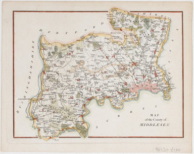
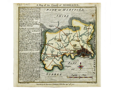
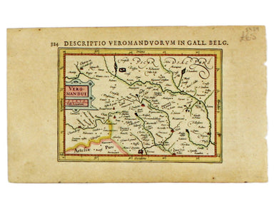
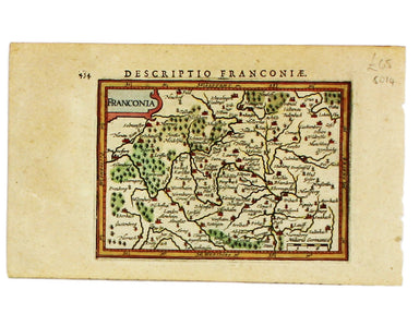
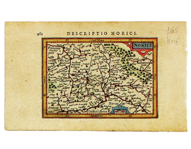
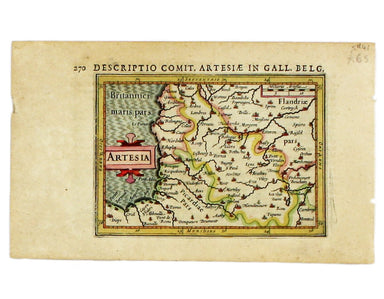
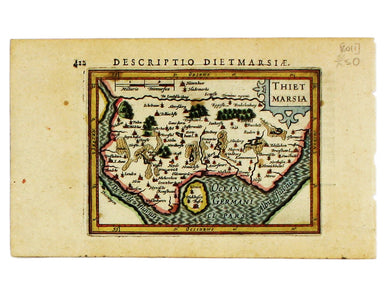
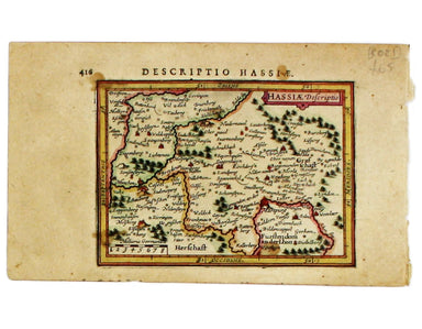
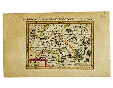
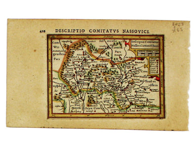
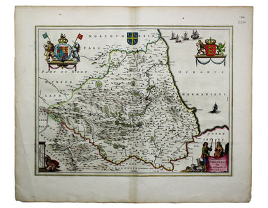
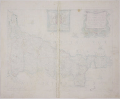
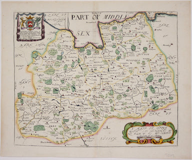
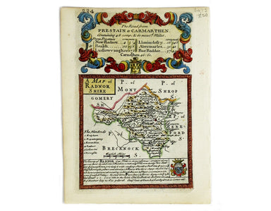
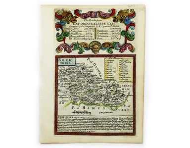

Badeslade & Toms’ Map of Middlesex
A Map of the County of Middlesex. Copper engraving, 15.5 x 15.5 cm, modern hand-colour, blank verso; a map of Middlesex engraved by Toms for Thomas...
View full detailsA Map of the County of Middlesex. Copper engraving, 15.5 x 15.5 cm, modern hand-colour, blank verso; a map of Middlesex engraved by Toms for Thomas...
View full detailsKarte von der Küste von Angola von dem Flusse Bengo bis an den Fluss Quanza Copper engraving, 21.5 x 27.5 cm, modern hand-colour, tiny wormtrack in...
View full detailsPartie de la Mer Glaciale, contenant la Nouvelle Zemble et le Pays de Samoiedes Copper engraving, 23 x 36.5 cm, recent hand-colour, blank verso.
Carte du Dètriot de Waeigats, ou de Nassau Copper engraving, 21.5 x 32 cm, recent hand-colour, blank verso. A map of the Yugorsky Strait, in the Ar...
View full detailsCarte du Grand Thibet. Pour Servir à l’Histoire Generale des Voyages. Tirée des Auteurs Anglois… Copper engraving, 23 x 26 cm, modern colour, blank...
View full detailsMoluccae insulae Copper engraving, 9.6 x 13.6 cm, recent hand-colour, a couple of wormholes bottom right, Latin text on verso. Map of the Maluku Is...
View full detailsAnglesey Insula; Wight olim Vectis; Insula Garnsey; Insula Iarsay. Copper engraving, 9.6 x 13.4 cm, recent hand-colour, Latin text on verso. From ...
View full detailsVeromandui Copper engraving, 9.5 x 13.4 cm, recent hand-colour, Latin text on verso. A map of the modern Aisne, named here for the Viromandui, a Be...
View full detailsFrisia Orientalis/Descriptio Comitatus Emdani Copper engraving, each 9.7 x 13.5 cm, modern hand-colour, Latin text on verso. A map of Eastern Fries...
View full detailsFranconia Copper engraving, each 9.7 x 13.5 cm, modern hand-colour, Latin text on verso. A map of Franconia, including Frankfurt and Nuremberg in m...
View full detailsGermania Copper engraving, each 9.7 x 13.5 cm, modern hand-colour, Latin text on verso. A map of Germany, from the first edition of Tabularum geogr...
View full detailsNorici Copper engraving, each 9.7 x 13.5 cm, modern hand-colour, Latin text on verso. A map of Northen Bavaria, from the first edition of Tabularum...
View full detailsNorthumbria, Cumberlandia et Dunelmensis Episcopatus. Copper engraving, 9.4 x 13.5 cm, recent hand-colour, Latin text on verso. A map of northern E...
View full detailsScotia Septentrion[alis]. Copper engraving, each 9.7 x 13.5 cm, modern hand-colour, Latin text on verso. A map of Northern Scotland, from the firs...
View full detailsWestrasia Copper engraving, each 9.7 x 13.5 cm, modern hand-colour, Latin text on verso. A map of Southwestern Germany, from the first edition of T...
View full detailsUdrone Copper engraving, 9.7 x 13.8 cm, recent hand-colour, Latin text on verso. A map of Udrone from the first edition of Tabularum geographicarum...
View full detailsArtesia Copper engraving, 9.5 x 13.4 cm, recent hand-colour, Latin text on verso; miniature map of Artois.
Brandenburg Copper engraving, 9.7 x 13.5 cm, modern hand-colour, Latin text on verso. A miniature map of Brandenburg, from the first edition of Tab...
View full detailsThietmarsia Copper engraving, each 9.7 x 13.5 cm, modern hand-colour, Latin text on verso. A miniature map of Dithmarschen in Holstein, flanked by ...
View full detailsHannonia Copper engraving, 9.5 x 13.4 cm, recent hand-colour, Latin text on verso; map of Hainault
Hassiae Descriptio Copper engraving, each 9.7 x 13.5 cm, modern hand-colour, trivial spotting, Latin text on verso. A miniature map of Hesse, from ...
View full detailsLeodiensis Dioecesis Copper engraving, 9.5 x 13.4 cm, recent hand-colour, Latin text on verso; map of Liège
Media Copper engraving, 9.4 x 13.4 cm, recent hand-colour, Latin text on verso. Miniature map of Meath from the first edition of Tabularum geograph...
View full detailsDescriptio Comitatus Nassovi Cattimeliboci Copper engraving, each 9.7 x 13.5 cm, modern hand-colour, trvial spotting, Latin text on verso. A miniat...
View full detailsTrans-Isula D. (Overijssel) Copper engraving, 9.5 x 13.4 cm, recent hand-colour, Latin text on verso; map of Overjissel
Prussia Copper engraving, each 9.7 x 13.5 cm, modern hand-colour, Latin text on verso. A miniature map of Prussia, from the first edition of Tabula...
View full detailsSalzburg et Carinthia Copper engraving, 10 x 13.5 cm, recent hand-colour, Latin text on verso; miniature map of Salzburg and Carinthia
Saxonia Copper engraving, each 9.7 x 13.5 cm, modern hand-colour, Latin text on verso. A miniature map of Saxony, from the first edition of Tabular...
View full detailsScotia. Copper engraving, 9.6 x 13.6 cm, recent hand-colour, Latin text on verso. A miniature map of Scotland from the first edition of Tabularum ...
View full detailsScotia! This tiny map of Scotland was engraved by Pieter van den Keere for the Caert-thresoor published by Cornelis Claesz and Barent Langenes in 1...
View full detailsPalatinatus Rheni Copper engraving, each 9.7 x 13.5 cm, modern hand-colour, Latin text on verso. A miniature map of the Electoral Palatinate, from ...
View full detailsDe Zype Copper engraving, 9.5 x 13.4 cm, recent hand-colour, Latin text on verso; map of the Zijpe polder
Copper engraving, sheet size 49.5 x 30 cm, map 18 x 24 cm, modern hand colour, set within Latin text with further text on verso. A map of the Fren...
View full detailsEpiscopatus Dunelmensis. Vulgo The Bishoprike of Durham Copper engraving, 38 x 49.5 cm, modern hand colour, single conjugate wormhole; map of Count...
View full detailsDevonia Vulgo Devonshire Copper engraving, 39.5 x 50.5 cm, map of Devon with modern hand colour, some spotting, French text on verso. Blaeu and th...
View full detailsElba Isola, olim Ilva. Copper engraving, sheet size 49.5 x 30 cm, map 20 x 25.5 cm, modern hand colour, set within Latin text with further text on ...
View full detailsCopper engraving, sheet size 49.5 x 30 cm, map 18 x 24 cm, modern hand colour, set within Latin text with further text on verso. A map of the Ital...
View full detailsMagni Mogolis Imperium Copper engraving, 42 x 52.5 cm, modern hand colour, slight spotting, closed centrefold split in lower margin, Latin text on ...
View full detailsA Mapp of ye County of Cornwal Copper engraving, 24.2 x 31.2 cm, map of Cornwall with modern hand-colour, blank verso. Blome published the first ne...
View full detailsA Mapp of ye County of Midlesex Copper engraving, 28.5 x 31 cm, first state of this map of Middlesex (with floral cartouche), modern hand-colour, b...
View full detailsA Mapp of Surrey with its hundreds Copper engraving, 25.5 x 31 cm, map of Surrey with modern hand-colour, blank verso. Blome published the first ne...
View full detailsCarte de L’Arabie, du Golfe Persique et de la Mer Rouge, avec L’Egypte, La Nubie et L’Abissinie. Copper engraving, 22.5 x 35 cm, recent hand colou...
View full detailsCarte de l’Isle de St. Domingue une des Grandes Antilles, Colonie Francoise et Espagnole Copper engraving, 23 x 34.5 cm, modern hand colour, blank ...
View full detailsLe Nouveau Mexique, avec la Partie Septentrionale de L’Ancien ou de la Nouvelle Espagne Copper engraving, 22.5 x 33 cm, modern hand colour, blank v...
View full detailsAn Accurate Map of the County Palatine of Chester […] Copper engraving, 41.5 x 50.5 cm, map of Cheshire with original hand-colour in outline and re...
View full detailsA Map of Radnorshire. Copper engraving, 18 x 12 cm, recent hand-colour, b/w strip-maps on verso. A map of Radnorshire engraved by Emanuel Bowen fo...
View full detailsHerefordshire Copper engraving, 18 x 12 cm, recent hand-colour, black and white strip-maps on verso. Map of Herefordshire engraved by Emanuel Bowen...
View full detailsBerkshire Copper engraving, 18 x 12 cm, recent hand-colour, black and white strip-maps on verso. Engraved by Emanuel Bowen for John Owen’s Britanni...
View full details