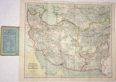
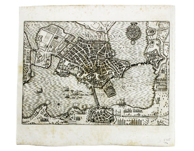
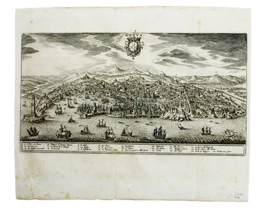
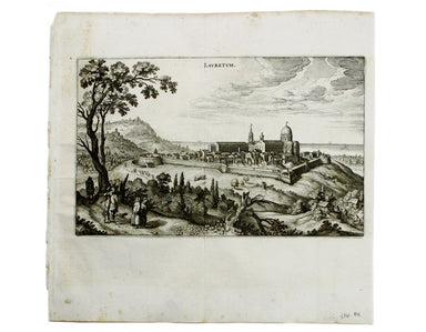
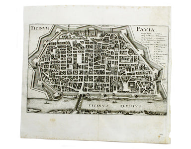
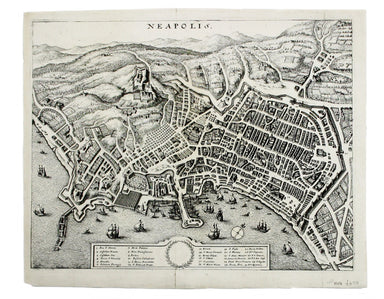
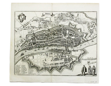
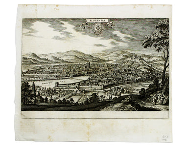
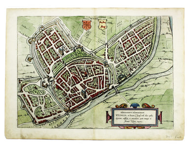
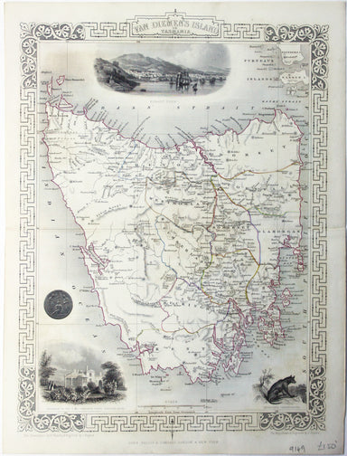
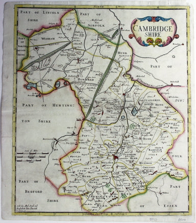
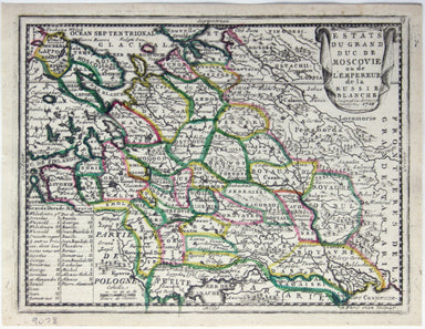
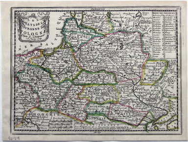
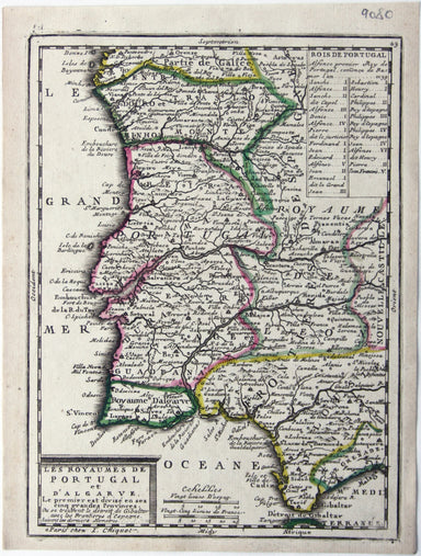
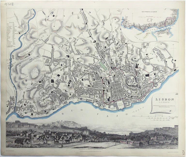
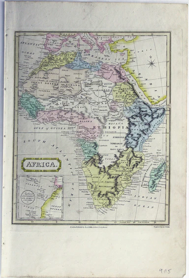
Merian's Plan of Mantua
This plan of Mantua was published by Merian and his heirs in various works, including the Itinerarium Italiae of 1640 and editions of the Theatrum ...
View full details
This plan of Mantua was published by Merian and his heirs in various works, including the Itinerarium Italiae of 1640 and editions of the Theatrum ...
View full details
This plan of Genoa was published by Merian and his heirs in various works, including the Itinerarium Italiae of 1640 and editions of the Theatrum E...
View full details
This plan of Palmanova (a Venetian town founded in 1593, sheltered behind innovative fortifications taking the form of a nine-pointed star) was pub...
View full details
This plan of Loreto (site of the Basilica della Santa Casa) was published by Merian and his heirs in various works, including the Itinerarium Itali...
View full details
This plan of Pavia (the ancient Ticinum) was published by Merian and his heirs in various works, including the Itinerarium Italiae of 1640 and edit...
View full details
This plan of Naples was published by Merian and his heirs in various works, including the Itinerarium Italiae of 1640 and editions of the Theatrum ...
View full details
This plan of Messina was published by Merian and his heirs in various works, including the Itinerarium Italiae of 1640 and editions of the Theatrum...
View full details
This map of Bremen was published by Merian and his heirs in various works, including the Theatrum Europaeum. Condition & Materials Copper engra...
View full details
This map of Rostock was published by Merian and his heirs in various works, including the Theatrum Europaeum. Condition & Materials Copper eng...
View full details
This plan of Florence was published by Merian and his heirs in various works, including the Itinerarium Italiae of 1640 and editions of the Theatru...
View full details
Brunopolis [with] Luneburgum [and] Brema [and] Aldenburgum Holsatiae Four north German towns are shown here on one sheet: Braunschweig, Lüneburg an...
View full details
Magdeburgum, a Venere quae hic quondam colebatur Parthenopolis dicta, metropolitica Saxoniae urbs The cartouche on this plan of Magdeburg refers to...
View full details
Fribergum Misinae The Civitates Orbis Terrarum was one of the most significant cartographic works of the late sixteenth-century, printed over 45 ye...
View full details
Wesalia in Ducatu Clivensi Urbs Clara Opibus The Civitates Orbis Terrarum was one of the most significant cartographic works of the late sixteenth...
View full details
[Title-page] Description de l’Univers Tome I This is the title-page for the first volume of Mallet’s Description de l’Univers printed by Denis Thie...
View full details
[Title-page] Le Nouveau Theatre du Monde ou Nouvel Atlas, Tome Troisieme Copper engraved title-page, 37.5 x 23.5 cm, later hand-colour, blank verso...
View full details
[Title-page] The English Atlas, Volume II Pitt worked in partnership with Janssonius’ heir Joannes van Waesbergen, and this title-page for the Germ...
View full details
[Title-page] Atlas Historique The classical muses on this title page represent Chronology, History, Navigation and Geography. Atlas braces himself ...
View full details
[Title-Page] Mercurio Geografico […] Tomo Secondo […] Condition & Materials Copper engraved title-page, 42 x 26.5 cm, black and white as issue...
View full details
This plan of Douai (Duacum) in northern France was published in the Civitates Orbis Terrarum, one of the most significant cartographic works of the...
View full details
This map of Mons in Belgium is from the Civitates Orbis Terrarum, one of the most significant cartographic works of the late sixteenth-century, pri...
View full details
This plan of Namur in Belgium is from the Civitates Orbis Terrarum, one of the most significant cartographic works of the late sixteenth-century, p...
View full details
This map of Limbourg or Limburg is from the Civitates Orbis Terrarum, one of the most significant cartographic works of the late sixteenth-century,...
View full details
This is the general title page for Blaeu’s town books of the Netherlands. The first volume features plans and views of the towns of the Northern p...
View full details
Eboracensis Comitatus […] pars Orientalis, vulgo East Riding. This map of the East Riding is from the second edition of Philemon Holland’s translat...
View full details
Wesmorlandia e comitatis. This map of Westmorland is from the second edition of Philemon Holland’s translation of Camden’s Britannia into English, ...
View full details
This map of Sussex was first issued in The London Magazine, which between 1747 and 1754 published a complete set of English county maps by Thomas K...
View full details
This map of Somerset was engraved by Emanuel Bowen for John Owen’s Britannia Depicta, a pocket road book derived from Ogilby’s innovative atlas of ...
View full details
This map of the Mughal Empire is dedicated by the Blaeu brothers to Joan Huydecoper van Maarsseveen (1599–1661), a prosperous dealer in pelts and a...
View full details
Beck’s diagram is possibly one of the most innovative and influential designs of the 20th century. First published in 1933, Beck remained directly ...
View full details
This map of Persia, Afghanistan and Balochistan is part of the Authentic Imperial Maps series published by the London Geographical Institute. Condi...
View full details
Founded in 1894, on the cusp of the Anglo-German naval arms race, the Navy League was a pressure group seeking to influence politicians and popular...
View full details
This map of Tasmania was engraved by John Rapkin for the ‘Illustrated Atlas'. John Rogers engraved the black and white vignettes including Hobart T...
View full details
Particulars, with Plans, Key Plan and Conditions of Sale of the Hoxton Estate The Hoxton estate passed by marriage from the Pitfield to the Sturt f...
View full details
This map of Poland was published in ‘Oddy’s New General Atlas of the World’. It is coloured according to the third partition of 1795, by which the ...
View full details
This is the Tuscan island of Elba, a map newly added to the ‘Atlas Novus’ in 1640. Koeman records that it was first published in the French text ed...
View full details
Robert Morden's maps were engraved to illustrate Gibson's edition of William Camden's Britannia, first published in 1695 and reprinted in various 1...
View full details
This map of Middlesex was engraved by Toms for Thomas Badeslade’s ‘Chorographia Britanniae’, an attractive pocket atlas which according to Badeslad...
View full details
Estats du Grand Duc de Moscovie ou de l’Empereur de la Russie Blanche This map of Muscovy, or European Russia, was published in Chiquet’s ‘Le nouve...
View full details
Les estats de la Couronne de Pologne This map of the Crown of the Kingdom of Poland was published in Chiquet’s ‘Le nouveau et curieux atlas géograp...
View full details
Les Royaumes de Portugal et d’Algarve This map of Portugal was published in Chiquet’s ‘Le nouveau et curieux atlas géographique et historique ...’....
View full details
Het Beloofde Landt Canaan door wandelt van onfen Salichmaeker Iesu Christo, nessens syne Apostelen Oriented to the west, this map of the Holy Land ...
View full details
This map of Lisbon was engraved by Josiah Henshall after William Barnard Clarke. It was published by the Society for the Diffusion of Useful Knowle...
View full details
This map of Asia was published in ‘Oddy’s New General Atlas of the World’. New South Wales appears here on the west coast of ‘New Holland’. James W...
View full details
This map of Africa features was published in ‘Oddy’s New General Atlas of the World’. It features an inset of the Azores and Cape Verde islands. Mu...
View full details
[Title page: Atlas Novus, volume IV] This is an architectural title page, engraved for the fourth volume of Blaeu’s Atlas Novus. The central panel ...
View full details
Clang, clang, clang went the trolley… Trolleybus services were introduced to London in 1931 and phased out between 1954 and 1962, making this one o...
View full details
Collins’ Chart of the Black Sea/Collins’ New Map of the Black Sea, shewing all the fortifications &c on an extended scale. Contemporary with th...
View full details