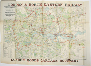
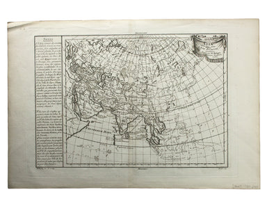
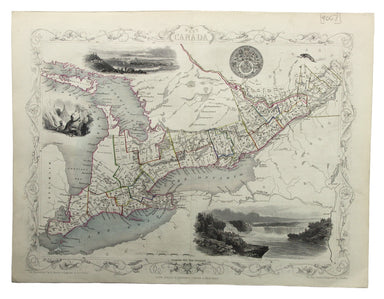
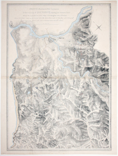
Philippe de Prétot’s Map of Ancient Asia
Asia veteribus nota. L’Asie ancienne, dirigée par M. Philippe This is a map of Asia as it was understood in the Greco-Roman world in classical anti...
View full details
Asia veteribus nota. L’Asie ancienne, dirigée par M. Philippe This is a map of Asia as it was understood in the Greco-Roman world in classical anti...
View full details
This map of West Canada was engraved by John Rapkin for the ‘Illustrated Atlas’. The map also includes black and white vignettes of Kingston, Ontar...
View full details
South America – British Guiana – Georgetown and mouths of Demerara and Essequibo Rivers This British chart of Georgetown shows soundings etc, with ...
View full details
This chart of Dublin bay shows soundings etc, with interior detail of relief and settlements (including eastern Dublin), and inset coastal profiles...
View full details
This British chart of Durban port was engraved by John and Charles Walker. It shows soundings etc, interior detail of relief and settlements includ...
View full details
Underground Map of Central London/A Guide to Underground Travel, Through Service Sth. Harrow and the West End Leboff and Demuth draw attention to t...
View full details
Underground Railways of London/What to see and how to travel: Map of the Electric Railways of London The continuation of lines in the margins is no...
View full details
Chart of the World on Mercator’s Projection, shewing the principal Ocean Steam Routes, the Submarine Telegraph &c This world map was published ...
View full details
The Falkland Islands, surveyed by Captains Robert Fitz Roy R.N., William Robinson R.N. and Bartholomew James Sulivan R.N. This map of the Falkland...
View full details
Joannes Janssonius II (1588-1664) married into the Hondius family and, with Henricus Hondius, worked on a revised edition of the Mercator-Hondius a...
View full details
A correct sketch of the northern seat of war, exhibiting the whole of the country, wherein the British troops under the command of His Royal Highne...
View full details
Plan du Siege de Namur avec les nouveaux travaux que sa Majesté y a fait adjouter qui sont marquees à la lettre A. Cette place fut reduitte à l’obb...
View full details
Carte générale des découvertes de l’Amiral de Fonte, representant le grande probabilité d’un Passage au Nord Ouest Maps depicting the purported voy...
View full details
Sinus Gangeticus; vulgo Golfo de Bengale nova descriptio This is a map of the Bay of Bengal with north oriented to the right. Petrus Schenk and Ger...
View full details
Karte von dem groessten theil des landes Jemen, Imame, Kaukeban &. &. […] This map of Yemen and the Red Sea follows the detailed maps by Ge...
View full details
This map of Algeria features an inset of the Bay of Algiers. Ottoman Algeria was a hub of privateering and the Mediterranean slave trade. Well know...
View full details
Plan Des Villes De Londres et de Westminster et leurs Faubourgs avec le Bourg de Southwark This is the first version of the map, before the date wa...
View full details
Map of the Occupied Areas / Carte des Zones d’Occupation / Karte der Besatzungs-Zonen mit Neuen Postleitgebieten / [in Cyrillic:] Karta Okkupacionn...
View full details
La VIII Table d’Angleterre/Anglesey, Wight, Vectis olim, Garnsey, Iarsay Islands around the British coast were often grouped, in various combinatio...
View full details
Blaeu and the rival Golden Age Dutch cartographic publishing house of Janssonius raced to bring out atlases of the British Isles in the 1630s and e...
View full details
Blaeu and the rival Golden Age Dutch cartographic publishing house of Janssonius raced to bring out atlases of the British Isles in the 1630s and e...
View full details
Map of the County of Middlesex from an Actual Survey The Greenwood brothers were land-surveyors from Yorkshire who compiled one of the last indepen...
View full details
Map of the County of Surrey from an Actual Survey The Greenwood brothers were land-surveyors from Yorkshire who compiled one of the last independen...
View full details
This map of Gloucester was engraved by Johannes Kip for 'The Ancient and Present State of Glostershire'. It is one of the earliest views of the cit...
View full details
Cardigan Shyre described with the due forme of the Shiretown as it was surveyed by JS. Anno 1610 John Speed (1552-1629) is unquestionably the most ...
View full details
This map of Monmouthshire and the Severn Estuary is from ‘the rarest edition of Blaeu’s Large Atlases’: only ten of the proposed eleven volumes wer...
View full details
La Parte Orientale della Irlanda che comprende le Provincie di Ulster e Leinster This is the eastern sheet of Cassini’s pleasing and unusual two sh...
View full details
This map of the northern part of Scotland is from the Hondius-Janssonius map publishing business, which traced its roots back to Gerardus Mercator....
View full details
Regionis, quae est circa Londinum […] This map follows Thomas Bowles’ ‘A New and Correct Map of Thirty Miles round London’ published c. 1740. The f...
View full details
England, with all the railways… This edition of Lizars’ railway map was published c. 1845, featuring lines such as the Maryport & Carlisle Rail...
View full details
Sketch illustrative of the operations in the vicinity of Bayonne during the winter of 1813. Against the Light Division at the village of Arcangues ...
View full details
Sketch of the action near the Vigia de la Barrosa fought 5th March, 1811 between the allied armies under Sir Thomas Graham, and the French […] Plan...
View full details
Movements of the two armies after the repulse of Marshall Massena’s attack upon the position of Bussaco This map was lithographed by AR Grive and p...
View full details
This District Railway map of Greater London shows the approximate extent from Epsom to Enfield and from Windsor to Grays, with inset of the Henley ...
View full details
Map of London shewing Goods, Coal and Passenger Stations, Depots and Receiving Offices of the London & North Eastern Railway, also the Ordinary...
View full details
Cruchley’s Improved Geographical Companion throughout England & Wales including part of Scotland In this map of England and Wales, we have an i...
View full details
Map of the North West Circuit of the Principality of Wales, comprising the Counties of Anglesey, Caernarfon & Merioneth, from an Actual Survey…...
View full details
A Map of the Principal Rivers shewing their courses, countries and comparative lengths The Society for the Diffusion of Useful Knowledge was founde...
View full details
This map covers the southern part of the subcontinent (Mumbai is near the upper border), and includes the northern part of Sri Lanka. Pink denotes ...
View full details
This map of the Black Sea has been updated to show the 300 miles of submarine telegraph cable laid between Varna and Balaclava by Robert Stirling N...
View full details
Le XVII Provinces des Pays Bas divisées en Provinces Unies connues sous le nom de Hollande, et en Pays Bas Catholiques connues sous le nom de Fland...
View full details
Pomeraniae Wandalicae Regionis Typ. [on sheet with] Livoniae Nova descriptio [and] Ducatus Oswieczensis et Zatoriensis Descriptio An early example ...
View full details
A Map of the County Palatine of Lancaster Divided into Hundreds and Parishes from an accurate Survey made in the years 1828 and 1829, For Hennet’s ...
View full details
Hollandiae Comitatus una cum Ultrajectino Dominio nec non maximis partibus Geldriae Ducatus, per C. Specht This example of Caspar Specht’s map has ...
View full details
Bradshaw’s map of the railways of England & Wales with part of Scotland, reduced from the highly accurate Ordnance Survey, presented to the sub...
View full details
The focus of this map is Toyama, a significant sea-port in what was once Etchu province on Honshu. On stylistic grounds the map appears to date fro...
View full details
South Pacific Ocean – Society Islands – Tahiti and Moorea (Otaheite and Eimeo) This chart was derived from French surveys of 1869 and 1885. The fir...
View full details
This map of Vienna was published by the SDUK. The Society for the Diffusion of Useful Knowledge was founded in 1826 with the high-minded aim of mak...
View full details