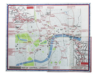
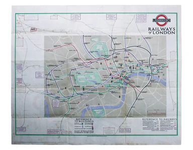
Braun & Hogenberg’s Plan of Namur
This plan of Namur in Belgium is from the Civitates Orbis Terrarum, one of the most significant cartographic works of the late sixteenth-century, p...
View full details
This plan of Namur in Belgium is from the Civitates Orbis Terrarum, one of the most significant cartographic works of the late sixteenth-century, p...
View full details
This map of Limbourg or Limburg is from the Civitates Orbis Terrarum, one of the most significant cartographic works of the late sixteenth-century,...
View full details
This is the general title page for Blaeu’s town books of the Netherlands. The first volume features plans and views of the towns of the Northern p...
View full details
Beck’s diagram is possibly one of the most innovative and influential designs of the 20th century. First published in 1933, Beck remained directly ...
View full details
This map of Persia, Afghanistan and Balochistan is part of the Authentic Imperial Maps series published by the London Geographical Institute. Condi...
View full details
Founded in 1894, on the cusp of the Anglo-German naval arms race, the Navy League was a pressure group seeking to influence politicians and popular...
View full details
This map of Tasmania was engraved by John Rapkin for the ‘Illustrated Atlas'. John Rogers engraved the black and white vignettes including Hobart T...
View full details
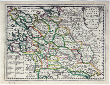
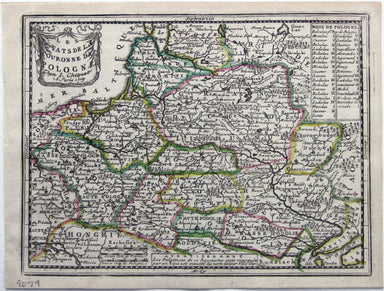
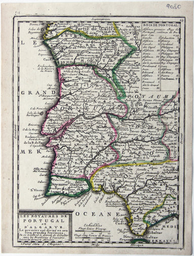
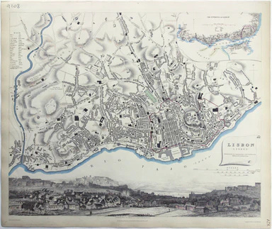
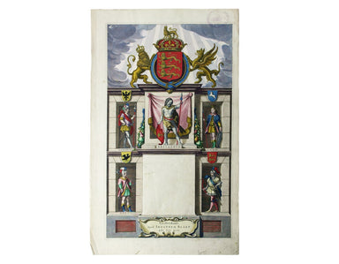
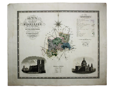
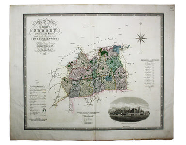
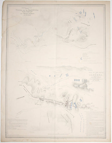
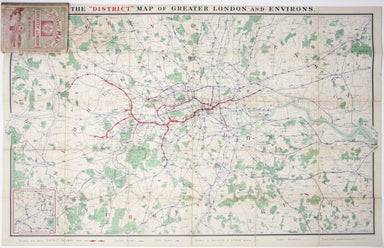
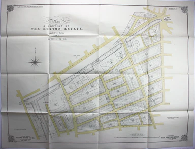
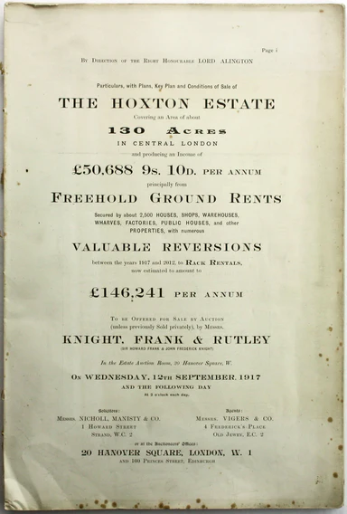
Particulars, with Plans, Key Plan and Conditions of Sale of the Hoxton Estate The Hoxton estate passed by marriage from the Pitfield to the Sturt f...
View full details
This map of Poland was published in ‘Oddy’s New General Atlas of the World’. It is coloured according to the third partition of 1795, by which the ...
View full details
This map of Middlesex was engraved by Toms for Thomas Badeslade’s ‘Chorographia Britanniae’, an attractive pocket atlas which according to Badeslad...
View full details
Estats du Grand Duc de Moscovie ou de l’Empereur de la Russie Blanche This map of Muscovy, or European Russia, was published in Chiquet’s ‘Le nouve...
View full details
Les estats de la Couronne de Pologne This map of the Crown of the Kingdom of Poland was published in Chiquet’s ‘Le nouveau et curieux atlas géograp...
View full details
Les Royaumes de Portugal et d’Algarve This map of Portugal was published in Chiquet’s ‘Le nouveau et curieux atlas géographique et historique ...’....
View full details
This map of Lisbon was engraved by Josiah Henshall after William Barnard Clarke. It was published by the Society for the Diffusion of Useful Knowle...
View full details
This map of Asia was published in ‘Oddy’s New General Atlas of the World’. New South Wales appears here on the west coast of ‘New Holland’. James W...
View full details
This map of Africa features was published in ‘Oddy’s New General Atlas of the World’. It features an inset of the Azores and Cape Verde islands. Mu...
View full details
[Title page: Atlas Novus, volume IV] This is an architectural title page, engraved for the fourth volume of Blaeu’s Atlas Novus. The central panel ...
View full details
Clang, clang, clang went the trolley… Trolleybus services were introduced to London in 1931 and phased out between 1954 and 1962, making this one o...
View full details
Originally published in the series ‘Twenty-Four Views in Hindostan’, a part-work issued 1802-1805 to illustrate Francis Blagdon’s ‘Brief History of...
View full details
From ‘Sketches at Home and Abroad’, printed by Charles Hullmandel for Charles Tilt. London Bridge and the Monument can be glimpsed through a forest...
View full details
The Opening of the New London Bridge by their most Gracious Majesties William the 4th & Queen Adelaide Our print depicts the river pageant cele...
View full details
Prospectus majoris viae, et Ecclesiae Sanctae Mariae in Londino / La Grande Ruë et l’Eglise Ste. Marie Jean François Daumont (fl. 1740-1775) was a ...
View full details
Collins’ Chart of the Black Sea/Collins’ New Map of the Black Sea, shewing all the fortifications &c on an extended scale. Contemporary with th...
View full details
This map of West Canada was engraved by John Rapkin for the ‘Illustrated Atlas’. The map also includes black and white vignettes of Kingston, Ontar...
View full details
Underground Map of Central London/A Guide to Underground Travel, Through Service Sth. Harrow and the West End Leboff and Demuth draw attention to t...
View full details
Underground Railways of London/What to see and how to travel: Map of the Electric Railways of London The continuation of lines in the margins is no...
View full details
Chart of the World on Mercator’s Projection, shewing the principal Ocean Steam Routes, the Submarine Telegraph &c This world map was published ...
View full details
The Falkland Islands, surveyed by Captains Robert Fitz Roy R.N., William Robinson R.N. and Bartholomew James Sulivan R.N. This map of the Falkland...
View full details
A correct sketch of the northern seat of war, exhibiting the whole of the country, wherein the British troops under the command of His Royal Highne...
View full details
Sinus Gangeticus; vulgo Golfo de Bengale nova descriptio This is a map of the Bay of Bengal with north oriented to the right. Petrus Schenk and Ger...
View full details
Karte von dem groessten theil des landes Jemen, Imame, Kaukeban &. &. […] This map of Yemen and the Red Sea follows the detailed maps by Ge...
View full details
This map of Algeria features an inset of the Bay of Algiers. Ottoman Algeria was a hub of privateering and the Mediterranean slave trade. Well know...
View full details
Map of the Occupied Areas / Carte des Zones d’Occupation / Karte der Besatzungs-Zonen mit Neuen Postleitgebieten / [in Cyrillic:] Karta Okkupacionn...
View full details
La VIII Table d’Angleterre/Anglesey, Wight, Vectis olim, Garnsey, Iarsay Islands around the British coast were often grouped, in various combinatio...
View full details
Blaeu and the rival Golden Age Dutch cartographic publishing house of Janssonius raced to bring out atlases of the British Isles in the 1630s and e...
View full details
Map of the County of Middlesex from an Actual Survey The Greenwood brothers were land-surveyors from Yorkshire who compiled one of the last indepen...
View full details
Map of the County of Surrey from an Actual Survey The Greenwood brothers were land-surveyors from Yorkshire who compiled one of the last independen...
View full details
This map of Monmouthshire and the Severn Estuary is from ‘the rarest edition of Blaeu’s Large Atlases’: only ten of the proposed eleven volumes wer...
View full details
London: Day & Son for FG Moon, 1846-49. Subscribers’ edition. Lithograph by Louis Haghe after Roberts, 34.5 x 51 cm, with original hand colou...
View full details
London: Day & Son for FG Moon, 1846-49. Subscribers’ edition. Lithograph by Louis Haghe after Roberts, 35.5 x 50 cm, with original hand colou...
View full details
London: Day & Son for FG Moon, 1846-49. Subscribers’ edition. Lithograph by Louis Haghe after Roberts, 50 x 35 cm, with original hand colour,...
View full details
London: Day & Son for FG Moon, 1846-49. Subscribers’ edition. Lithograph by Louis Haghe after Roberts, 32 x 47.5 cm, with original hand colou...
View full details
London: Day & Son for FG Moon, 1846-49. Tinted lithograph by Louis Haghe after Roberts, 48 x 32.5 cm, closed marginal tear (not affecting imag...
View full details
London: Day & Son for FG Moon, 1846-49. Tinted lithograph, 48.5 x 32.5 cm, by Louis Haghe after Roberts, creases in lower margin, not affectin...
View full details
London: Day & Son for FG Moon, 1842-45. Tinted lithograph by Louis Haghe after Roberts, 33.5 x 53 cm, slight marginal waterstaining. From the ...
View full details
London: Day & Son for FG Moon, 1842-45. Tinted lithograph by Louis Haghe after Roberts, 51 x 33.5 cm, light marginal waterstaining. From the f...
View full details
London: Day & Son for FG Moon, 1842-45. Tinted lithograph by Louis Haghe after Roberts, 33 x 48.5 cm, minor spotting. From the first edition o...
View full details
London: Day & Son for FG Moon, 1846-49. Tinted lithograph by Louis Haghe after Roberts, 33 x 48.5 cm, minor spotting. From the first edition o...
View full details