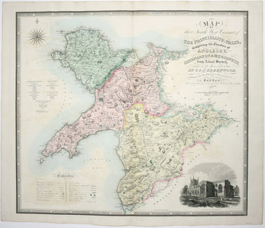
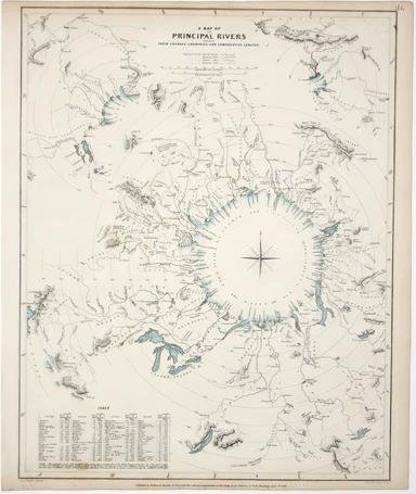
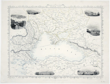
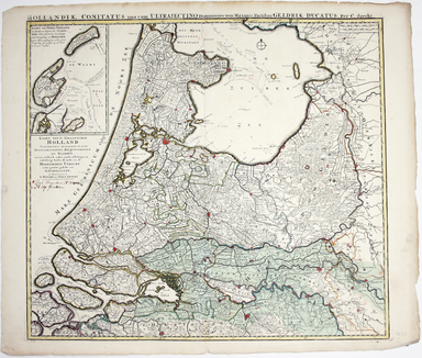
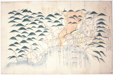
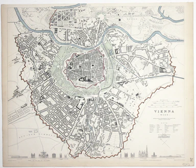
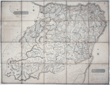
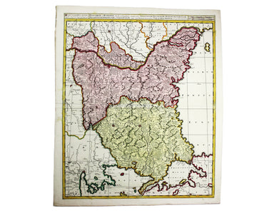
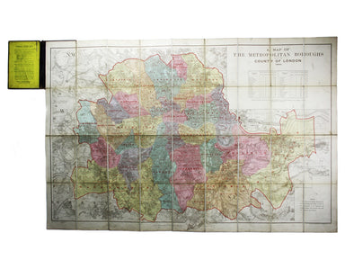
Map of Allied-Occupied Germany & Austria
Map of the Occupied Areas / Carte des Zones d’Occupation / Karte der Besatzungs-Zonen mit Neuen Postleitgebieten / [in Cyrillic:] Karta Okkupacionn...
View full details
Map of the Occupied Areas / Carte des Zones d’Occupation / Karte der Besatzungs-Zonen mit Neuen Postleitgebieten / [in Cyrillic:] Karta Okkupacionn...
View full details
La VIII Table d’Angleterre/Anglesey, Wight, Vectis olim, Garnsey, Iarsay Islands around the British coast were often grouped, in various combinatio...
View full details
Blaeu and the rival Golden Age Dutch cartographic publishing house of Janssonius raced to bring out atlases of the British Isles in the 1630s and e...
View full details
Blaeu and the rival Golden Age Dutch cartographic publishing house of Janssonius raced to bring out atlases of the British Isles in the 1630s and e...
View full details
Map of the County of Middlesex from an Actual Survey The Greenwood brothers were land-surveyors from Yorkshire who compiled one of the last indepen...
View full details
Map of the County of Surrey from an Actual Survey The Greenwood brothers were land-surveyors from Yorkshire who compiled one of the last independen...
View full details
This map of Monmouthshire and the Severn Estuary is from ‘the rarest edition of Blaeu’s Large Atlases’: only ten of the proposed eleven volumes wer...
View full details
London: Day & Son for FG Moon, 1846-49. Subscribers’ edition. Lithograph by Louis Haghe after Roberts, 34.5 x 51 cm, with original hand colou...
View full details
London: Day & Son for FG Moon, 1846-49. Subscribers’ edition. Lithograph by Louis Haghe after Roberts, 35.5 x 50 cm, with original hand colou...
View full details
London: Day & Son for FG Moon, 1846-49. Subscribers’ edition. Lithograph by Louis Haghe after Roberts, 50 x 35 cm, with original hand colour,...
View full details
London: Day & Son for FG Moon, 1846-49. Subscribers’ edition. Lithograph by Louis Haghe after Roberts, 32 x 47.5 cm, with original hand colou...
View full details
London: Day & Son for FG Moon, 1846-49. Tinted lithograph by Louis Haghe after Roberts, 48 x 32.5 cm, closed marginal tear (not affecting imag...
View full details
London: Day & Son for FG Moon, 1846-49. Tinted lithograph, 48.5 x 32.5 cm, by Louis Haghe after Roberts, creases in lower margin, not affectin...
View full details
London: Day & Son for FG Moon, 1842-45. Tinted lithograph by Louis Haghe after Roberts, 33.5 x 53 cm, slight marginal waterstaining. From the ...
View full details
London: Day & Son for FG Moon, 1842-45. Tinted lithograph by Louis Haghe after Roberts, 51 x 33.5 cm, light marginal waterstaining. From the f...
View full details
London: Day & Son for FG Moon, 1842-45. Tinted lithograph by Louis Haghe after Roberts, 33 x 48.5 cm, minor spotting. From the first edition o...
View full details
London: Day & Son for FG Moon, 1846-49. Tinted lithograph by Louis Haghe after Roberts, 33 x 48.5 cm, minor spotting. From the first edition o...
View full details
England, with all the railways… This edition of Lizars’ railway map was published c. 1845, featuring lines such as the Maryport & Carlisle Rail...
View full details
Sketch illustrative of the operations in the vicinity of Bayonne during the winter of 1813. Against the Light Division at the village of Arcangues ...
View full details
Sketch of the action near the Vigia de la Barrosa fought 5th March, 1811 between the allied armies under Sir Thomas Graham, and the French […] Plan...
View full details
Movements of the two armies after the repulse of Marshall Massena’s attack upon the position of Bussaco This map was lithographed by AR Grive and p...
View full details
This District Railway map of Greater London shows the approximate extent from Epsom to Enfield and from Windsor to Grays, with inset of the Henley ...
View full details
Map of London shewing Goods, Coal and Passenger Stations, Depots and Receiving Offices of the London & North Eastern Railway, also the Ordinary...
View full details
Cruchley’s Improved Geographical Companion throughout England & Wales including part of Scotland In this map of England and Wales, we have an i...
View full details
Map of the North West Circuit of the Principality of Wales, comprising the Counties of Anglesey, Caernarfon & Merioneth, from an Actual Survey…...
View full details
A Map of the Principal Rivers shewing their courses, countries and comparative lengths The Society for the Diffusion of Useful Knowledge was founde...
View full details
This map covers the southern part of the subcontinent (Mumbai is near the upper border), and includes the northern part of Sri Lanka. Pink denotes ...
View full details
European Dominions of the Ottomans, or Turkey in Europe Greece had become an independent nation after the war of 1821-30, but most other Balkan sta...
View full details
This map of the Black Sea has been updated to show the 300 miles of submarine telegraph cable laid between Varna and Balaclava by Robert Stirling N...
View full details
Le XVII Provinces des Pays Bas divisées en Provinces Unies connues sous le nom de Hollande, et en Pays Bas Catholiques connues sous le nom de Fland...
View full details
A Map of the County Palatine of Lancaster Divided into Hundreds and Parishes from an accurate Survey made in the years 1828 and 1829, For Hennet’s ...
View full details
Hollandiae Comitatus una cum Ultrajectino Dominio nec non maximis partibus Geldriae Ducatus, per C. Specht This example of Caspar Specht’s map has ...
View full details
Bradshaw’s map of the railways of England & Wales with part of Scotland, reduced from the highly accurate Ordnance Survey, presented to the sub...
View full details
The focus of this map is Toyama, a significant sea-port in what was once Etchu province on Honshu. On stylistic grounds the map appears to date fro...
View full details
South Pacific Ocean – Society Islands – Tahiti and Moorea (Otaheite and Eimeo) This chart was derived from French surveys of 1869 and 1885. The fir...
View full details
This map of Vienna was published by the SDUK. The Society for the Diffusion of Useful Knowledge was founded in 1826 with the high-minded aim of mak...
View full details
Un-titled, undated and without a printer, this exceptionally scarce early poster was created for display in stations, but establishing which ones p...
View full details
Our example of the map has been annotated in ink to show the early expansion of the railway system, with railways completed and under construction....
View full details
If thou art worn and hard beset with sorrows that thou wouldst forget… Go to the woods and hills; no tears dim the sweet look that nature wears. He...
View full details
This pictorial map of London employs an unusual form of Turkish fold which makes use of inclined folding lines. The map is a simplified pocket vers...
View full details
MacDonald Gill, brother of Eric, was a successful commercial artist in his own right, and a noted calligrapher who designed the font used on all he...
View full details
This iteration of the UERL common design marks George Philip & Son’s first official map for the Underground Group; the firm had designed the fi...
View full details
The earliest versions of this map advertised the Franco-British Exhibition which closed at the end of October 1908, marked here as ‘Exhibition’. In...
View full details
Our map shows bus, tram and train services operated by the Underground Group and is very similar to the pocket map issued in guidebooks c. 1924. T...
View full details
London: Day & Son for FG Moon, 1842-45. Tinted lithograph by Louis Haghe after Roberts, 35.5 x 51 cm, minor spotting. From the first edition o...
View full details
Signed limited edition screenprint Colour screenprint, sheet size 78 x 57.5 cms, signed by the artist and inscribed 'AP' (Artist’s Proof) in pencil...
View full details
Signed limited edition screenprint Colour screenprint, sheet size 78 x 57.5 cms, signed by the artist and inscribed 'AP' (Artist’s Proof) in pencil...
View full details
Signed limited edition screenprint Colour screenprint, sheet size 78 x 57.5 cms, signed by the artist and inscribed 'AP' (Artist’s Proof) in pencil...
View full details