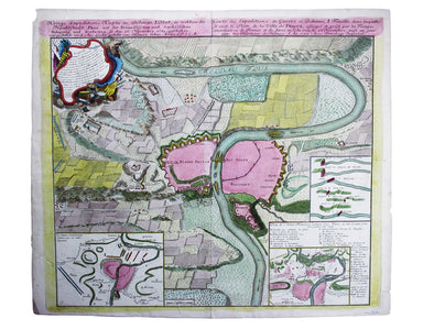
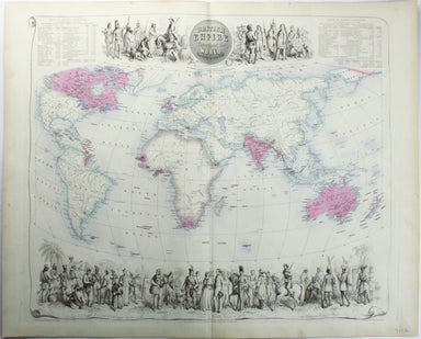
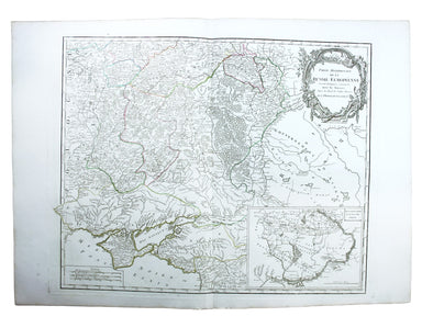
Magini’s Map of Padua
This significant and original regional map of Padua is from Magini's great work, the first detailed national atlas of Italy, published posthumously...
View full details
This significant and original regional map of Padua is from Magini's great work, the first detailed national atlas of Italy, published posthumously...
View full details
This map of the Balearics, Corsica, Sardinia and Valetta was published by the SDUK The Society for the Diffusion of Useful Knowledge was founded in...
View full details
This map of Turin was published by the SDUK. The Society for the Diffusion of Useful Knowledge was founded in 1826 with the high-minded aim of maki...
View full details
Condition & Materials Copper engraving, 21 x 25.5 cm, original hand-colour, on a folio leaf 37 x 29 cm, blank verso.
Underground Railways of London What to see and how to travel: Map of the Electric Railways of London Condition & Materials Summer 1925 issue of...
View full details
Karte von der Insel St Lucia This map of the Caribbean island of St Lucia was published in the Dutch edition of Prévost's Histoire Générale des Voy...
View full details
This map of the British Isles and northwestern Europe charts George Edwards's travels between 1716 and 1730 and features male and female stag beetl...
View full details
Scandinavia complectens Sveciae, Daniae et Norvegiae Regna ex novissimis subsidiis delineata et ad Leges Projectionis Stereographicae legitimae red...
View full details
Graeciae Pars Meridionalis / Graciae Antiquae Tabula Nova in qua locorum situs tum ad distantias itinerarias tum ad Observationes Astronomicas exac...
View full details
Gros Britanni[en] oder Engelland Schottland und Irrland The cartouche of this map is dominated by the Hanoverian coat of arms, and the legend on th...
View full details
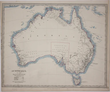
This map of Australia has a table in the bottom left, showing the European population (supposedly revised to 1846 but with the original figure give...
View full details
Metropolitan Goods Conference Map of Collection & Delivery Boundary This map is a variant of the London plan typically issued with Kelly’s Dire...
View full details
An accurate map of the County of Worcester divided into its hundreds and drawn from the best authorities. Illustrated with historical extracts rela...
View full details
British Empire Throughout the World Exhibited in One View This is a highly decorative map of the British Empire by John Bartholemew, with British p...
View full details
Survey of the country around London to the distance of thirty two miles from St Paul’s The map extends between Ware and Chatham, Bray and Dorking. ...
View full details
District within ¼ mile radius [of] Manor House Stanford’s was a firm of map publishers as well as map retailers until after the Second World War, w...
View full details
Garbutt believed he had ‘rescued’ the London Underground map from the clutches of Harold Hutchison and his ‘ham-fisted parody’ of Beck’s designs. H...
View full details
This is an LNER colliery map covering the midlands and north of England and Wales ('Collieries in Yorkshire, Nottinghamshire, Derbyshire, Lancashir...
View full details
Blome published the first new series of county maps in the sixty years since the appearance of John Speed’s ‘Theatre’. In the straightened financia...
View full details
The United Nations was established in October 1945, and Bullock’s map is a joyful celebration of what promised to be a more effective successor to ...
View full details
Partie Méridionale de la Russie Européenne This is a late state of Robert de Vaugondy’s map of southern Russia, Ukraine and parts of Poland. The or...
View full details
District within ¼ mile radius [of] Uxbridge Stanford’s was a firm of map publishers as well as map retailers until after the Second World War, with...
View full details
The guide seems to have been aimed at an American audience, with several pages devoted to converting prices in pounds, shillings and pence into dol...
View full details
Benjamin Getzel Lewis' map of the London underground shows the Victoria Line under construction in the originally proposed colour Lewis (1900-1966)...
View full details
The Evening News was responsible for coining the name ‘Bakerloo Line’ for the Baker Street and Waterloo Railway, and here the newspaper makes a rel...
View full details
Carte de l’Italie, dans laquelle sont tracées les Routes des Postes This is a later state of Robert de Vaugondy’s road map of Italy, showing the Ve...
View full details
Le Royaume de Boheme, le Duche de Silesie, et les Marquisats de Moravie et Lusace, dressés d’apres les cartes de Muller The second state of Robert ...
View full details
Le Royaume de Hongrie, Principaute de Transilvanie, Sclavonie, Croatie, et partie de la Principaute de Valaquie, de la Bosnie, de la Servie et de l...
View full details
Archipel des Indes Orientales, qui comprend les Isles de la Sonde, Moluques et Philippines, tirées des Cartes du Neptune Oriental This map of Indon...
View full details
L’Empire de la Chine dressé d’apres les Cartes de l’Atlas Chinois This detailed and relatively accurate map of China, Korea and Taiwan was derived ...
View full details
This is a view showing London before the Great Fire, from the South Bank of the Thames, including London Bridge and old St Paul’s. Principal buildi...
View full details
This map of South Africa, including an inset of Cape Town, was engraved by John & Charles Walker. It was published by the SDUK. The Society for...
View full details
Blatt 29. Warmbad This map covers the Karas region in modern Namibia (then German South West Africa), which was the scene of one of the earliest at...
View full details
Mae Nam Wen and Entrance, Surveyed by the Hydrographic Department, Royal Thai Navy, March-May 1944 This is a Thai chart of the Mae Nam Welu estuary...
View full details
Published in March 1935, this is a commercially available map showing the operating area of the recently formed London Passenger Transport Board, a...
View full details
This map of Sri Lanka was published in the first trade edition of Stanford’s ‘London Atlas’. Edward Stanford (senior) acquired Arrowmsith's stock i...
View full details
Beck’s diagram is possibly one of the most innovative and influential designs of the twentieth century. First published in 1933, Beck remained dire...
View full details
District within ¼ mile radius [of] Paddington Praed Street Stanford’s was a firm of map publishers as well as map retailers until after the Second ...
View full details
Garbutt believed he had ‘rescued’ the London Underground map from the clutches of Harold Hutchison and his ‘ham-fisted parody’ of Beck’s designs. H...
View full details
The introduction of Beck's diagram did not obviate the need for geographically accurate maps, which pinpointed the location of Underground stations...
View full details
De Maginot – En Siegfried Line. Met alle steden, germeenten, spoorwegen, verstingen en versterkingen, bosschen, heuvels, enz. This map was publishe...
View full details
This map of the world is coloured by continent, with the exception of Russian America which is coloured as an extension of Asia. It was published i...
View full details
This map of Poland was engraved by Samuel John Neele for the atlas volume to ‘Cruttwell’s Gazeteer’, published by G & JJ Robinson. Condition &a...
View full details
Syriae sive Soriae, nova et accurata descriptio Petrus Schenk and Gerard Valk often worked in partnership, towards the end of the Dutch Golden Age,...
View full details
This map of New Zealand was published in the second trade edition of Stanford’s London Atlas. Edward Stanford (senior) acquired Arrowmsith's stock ...
View full details
La Castille Vieille et Nouvelle This map shows Old and New Castile in central Spain. Condition & Materials Copper engraving, 44.5 x 55.5 cm, or...
View full details
Cheffins’s Map of the English & Scotch Railways Cheffins’s Map of the Railways in England & Scotland, accurately delineating all the lines ...
View full details
Kreigs Expeditions Karte in Bohmen I Blat, in welchern die Haubstadt Prag mit der Franzofsischen und Saechsischen Belegerug und Eroberung, so den 2...
View full details