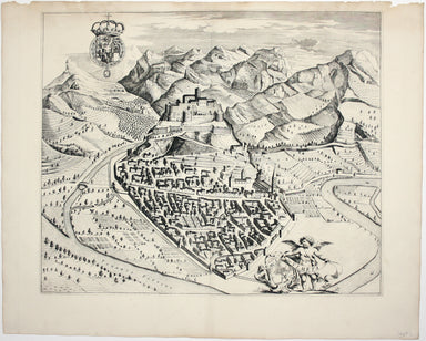
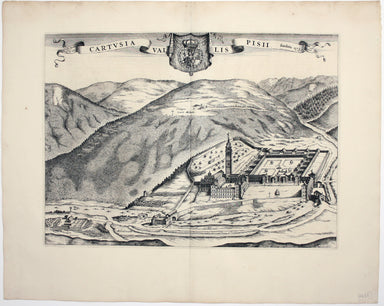
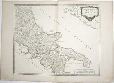
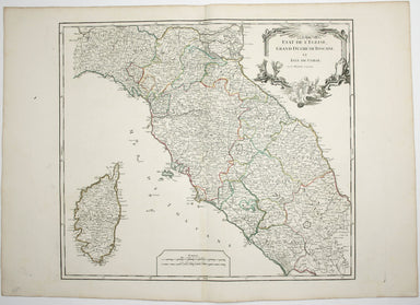
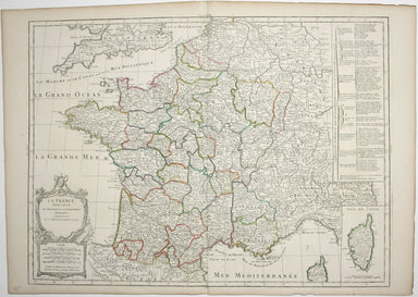
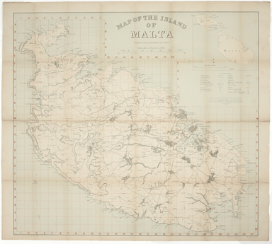
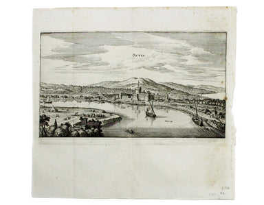
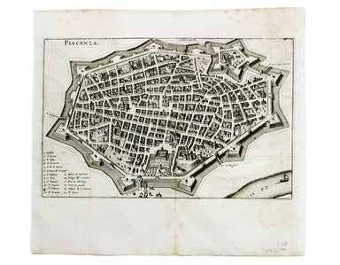
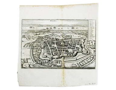
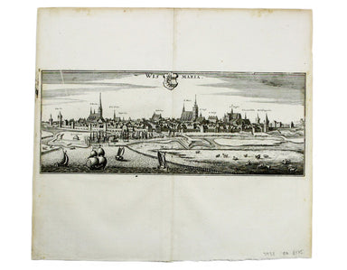
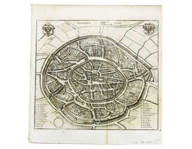
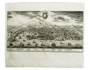
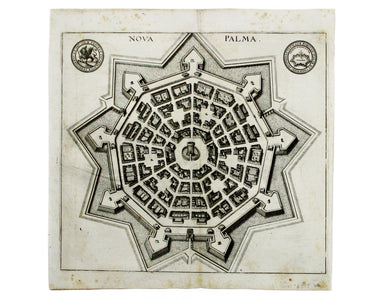
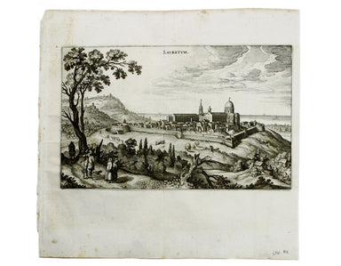
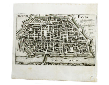
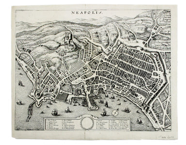
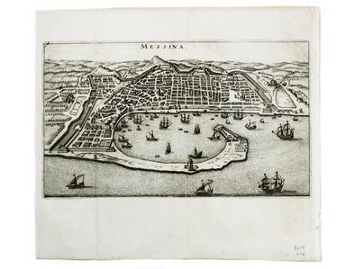
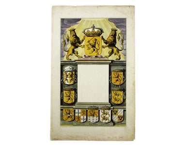
SDUK Map of Antwerp
This map of Antwerp, engraved by Benjamin Rees Davies after William Barnard Clarke, includes elevations of principal buildings and a view of the ci...
View full details
This map of Antwerp, engraved by Benjamin Rees Davies after William Barnard Clarke, includes elevations of principal buildings and a view of the ci...
View full details
Camaldulensium, nondum omnino absoluta ad Lancei oppidum eremus This is the Camaldolese hermitage near Lanzo Torinese in Piedmont (which is visible...
View full details
This is a map of Revello, near Cuneo in Piedmont. Blaeu’s townbook of Savoy and Piedmont was first published by the Blaeu heirs in 1682, but the pl...
View full details
This is a map of Ormea, near Cuneo in Piedmont. Blaeu’s townbook of Savoy and Piedmont was first published by the Blaeu heirs in 1682, but the plat...
View full details
Spain and Portugal. Reduced from the large map in four sheets James Wyld senior established a highly successful firm of map publishers, which passe...
View full details
Cartusia Vallis Pisii, fundata 1173 This is the Charterhouse of Pesio, a Carthusian foundation near Cuneo in Piedmont. Blaeu’s townbook of Savoy an...
View full details
Pomerania, running along the Baltic coast between Rostock and Gdansk, is now divided between Germany and Poland. The 'Atlas Minor’ was a pocket atl...
View full details
This map of Stockholm, with a view of of the city on a scroll bottom left, was published by the SDUK. The Society for the Diffusion of Useful Knowl...
View full details
This map shows the ‘Germanic’ regions of Europe, including the Low Countries, Poland and Austria, and was engraved by Jodocus Hondius for the ‘Atla...
View full details
Britannia et Normandia cum consiniis This map of Brittany and Normandy was engraved by Jodocus Hondius for the ‘Atlas Minor’. Condition & Mater...
View full details
Le Royaume de Hongrie, ou se trouvent la Transilvanie, la Moldavie, la Valaquie, la Bosnie la Servie et la Bulgarie, &c Our map of Hungary and ...
View full details
Partie Septentrionale du Royaume de Naples This is a later state of Robert de Vaugondy’s map of the northern part of the Kingdom of Naples. The ori...
View full details
Partie Septentrionale de la Couronne de Castille où se trouvent les Royaumes de Castille Vieille, de Leon, de Gallice, des Asturies, la Biscaye et ...
View full details
Etat de l’Eglise, Grand Duché de Toscane, et Isle de Corse This is a later state of Robert de Vaugondy’s map of the Papal States, Tuscany and Corsi...
View full details
Environs de Paris This is a later state of Robert de Vaugondy’s road map of Italy, showing the Venetian Republic, Papal States, Kingdom of Naples e...
View full details
La France divisée suivant ses Provinces ou Gouvernemens Militaires This map of France is coloured by departments, with a table listing different fo...
View full details
Nieuwe Kaarte van der XVII Nederlandsche Provincien: waar in aangewezen worden de landen door den Koning van Vrankryk geconquesteerd als mede die v...
View full details
This is a collection of 61 intelligence handbooks, 1943-1945, covering enemy and occupied countries and compiled by the Foreign Office and Ministry...
View full details
In the 1920s Valletta was the location of the Royal Navy's Mediterranean Fleet's headquarters. Prepared on the island, this map of Malta has a grid...
View full details
The framing device used by this children’s atlas is a little dark: Filip and his sister Cora are orphans, living with their aunt and uncle and cous...
View full details
Les Vignobles de France – Vins de Champagne Government and national wine trade bodies sponsored Louis Larmat’s regional wine atlases in the 1940s a...
View full details
This is a map of the Italian island of Sardinia, oriented with north to the left of the map. Condition & Materials Copper engraving, sheet size...
View full details
This view shows the major eruption of Vesuvius in December 1631, published by Merian and his heirs in various works, including the Itinerarium Ital...
View full details
This is a view of the Solfatara volcanic crater, mythological home of Vulcan in the Phlegraean Fields at Pozzuoli, near Naples. It was published by...
View full details
This plan of of Ostia was published by Merian and his heirs in various works, including the Itinerarium Italiae of 1640, the Archontologia cosmica ...
View full details
This plan of Piacenza was published by Merian and his heirs in various works, including the Itinerarium Italiae of 1640, the Archontologia cosmica ...
View full details
This map of Baden in Switzerland was published by Merian and his heirs in various works, including the Archontologia cosmica, Theatrum Europaeum an...
View full details
This map of Stade was published by Merian and his heirs in various works, including the Theatrum Europaeum. Condition & Materials Copper engrav...
View full details
This map of Wismar was published by Merian and his heirs in various works, including the Theatrum Europaeum. Condition & Materials Copper engr...
View full details
This map of Aachen, or Aix-la-Chapelle, was published by Merian and his heirs in various works, including the Theatrum Europaeum. Condition & M...
View full details
This plan of Mantua was published by Merian and his heirs in various works, including the Itinerarium Italiae of 1640 and editions of the Theatrum ...
View full details
This plan of Genoa was published by Merian and his heirs in various works, including the Itinerarium Italiae of 1640 and editions of the Theatrum E...
View full details
This plan of Palmanova (a Venetian town founded in 1593, sheltered behind innovative fortifications taking the form of a nine-pointed star) was pub...
View full details
This plan of Loreto (site of the Basilica della Santa Casa) was published by Merian and his heirs in various works, including the Itinerarium Itali...
View full details
This plan of Pavia (the ancient Ticinum) was published by Merian and his heirs in various works, including the Itinerarium Italiae of 1640 and edit...
View full details
This plan of Naples was published by Merian and his heirs in various works, including the Itinerarium Italiae of 1640 and editions of the Theatrum ...
View full details
This plan of Messina was published by Merian and his heirs in various works, including the Itinerarium Italiae of 1640 and editions of the Theatrum...
View full details
This map of Bremen was published by Merian and his heirs in various works, including the Theatrum Europaeum. Condition & Materials Copper engra...
View full details
This map of Rostock was published by Merian and his heirs in various works, including the Theatrum Europaeum. Condition & Materials Copper eng...
View full details
This plan of Florence was published by Merian and his heirs in various works, including the Itinerarium Italiae of 1640 and editions of the Theatru...
View full details
Brunopolis [with] Luneburgum [and] Brema [and] Aldenburgum Holsatiae Four north German towns are shown here on one sheet: Braunschweig, Lüneburg an...
View full details
Magdeburgum, a Venere quae hic quondam colebatur Parthenopolis dicta, metropolitica Saxoniae urbs The cartouche on this plan of Magdeburg refers to...
View full details
Fribergum Misinae The Civitates Orbis Terrarum was one of the most significant cartographic works of the late sixteenth-century, printed over 45 ye...
View full details
Wesalia in Ducatu Clivensi Urbs Clara Opibus The Civitates Orbis Terrarum was one of the most significant cartographic works of the late sixteenth...
View full details
This plan of Douai (Duacum) in northern France was published in the Civitates Orbis Terrarum, one of the most significant cartographic works of the...
View full details
This map of Mons in Belgium is from the Civitates Orbis Terrarum, one of the most significant cartographic works of the late sixteenth-century, pri...
View full details
This plan of Namur in Belgium is from the Civitates Orbis Terrarum, one of the most significant cartographic works of the late sixteenth-century, p...
View full details
This map of Limbourg or Limburg is from the Civitates Orbis Terrarum, one of the most significant cartographic works of the late sixteenth-century,...
View full details