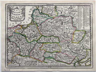
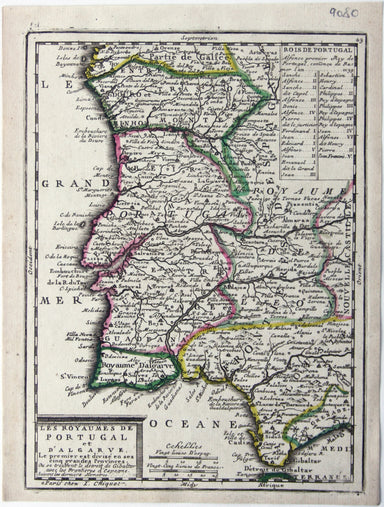
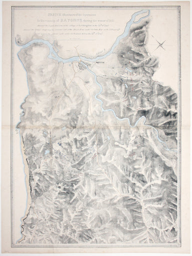
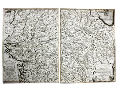
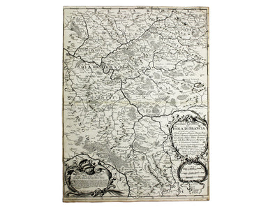
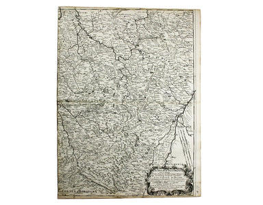
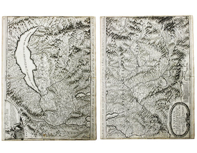
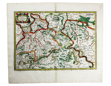
Braun & Hogenberg’s Plan of Namur
This plan of Namur in Belgium is from the Civitates Orbis Terrarum, one of the most significant cartographic works of the late sixteenth-century, p...
View full details
This plan of Namur in Belgium is from the Civitates Orbis Terrarum, one of the most significant cartographic works of the late sixteenth-century, p...
View full details
This map of Limbourg or Limburg is from the Civitates Orbis Terrarum, one of the most significant cartographic works of the late sixteenth-century,...
View full details
This is the general title page for Blaeu’s town books of the Netherlands. The first volume features plans and views of the towns of the Northern p...
View full details
Carte de la Normandie, divisée par Generalités et subdivisée par Elections Condition & Materials Folding map of Normandy, 68 x 102.5 cm, origin...
View full details
This map of Poland was published in ‘Oddy’s New General Atlas of the World’. It is coloured according to the third partition of 1795, by which the ...
View full details
This is the Tuscan island of Elba, a map newly added to the ‘Atlas Novus’ in 1640. Koeman records that it was first published in the French text ed...
View full details
This map shows the Swedish Empire, including Finland and Swedish Livonia. It waspublished in Chiquet’s ‘Le nouveau et curieux atlas géographique et...
View full details
Les estats de la Couronne de Pologne This map of the Crown of the Kingdom of Poland was published in Chiquet’s ‘Le nouveau et curieux atlas géograp...
View full details
Les Royaumes de Portugal et d’Algarve This map of Portugal was published in Chiquet’s ‘Le nouveau et curieux atlas géographique et historique ...’....
View full details
This map of Lisbon was engraved by Josiah Henshall after William Barnard Clarke. It was published by the Society for the Diffusion of Useful Knowle...
View full details
A correct sketch of the northern seat of war, exhibiting the whole of the country, wherein the British troops under the command of His Royal Highne...
View full details
Plan du Siege de Namur avec les nouveaux travaux que sa Majesté y a fait adjouter qui sont marquees à la lettre A. Cette place fut reduitte à l’obb...
View full details
Map of the Occupied Areas / Carte des Zones d’Occupation / Karte der Besatzungs-Zonen mit Neuen Postleitgebieten / [in Cyrillic:] Karta Okkupacionn...
View full details
Sketch illustrative of the operations in the vicinity of Bayonne during the winter of 1813. Against the Light Division at the village of Arcangues ...
View full details
Sketch of the action near the Vigia de la Barrosa fought 5th March, 1811 between the allied armies under Sir Thomas Graham, and the French […] Plan...
View full details
Movements of the two armies after the repulse of Marshall Massena’s attack upon the position of Bussaco This map was lithographed by AR Grive and p...
View full details
European Dominions of the Ottomans, or Turkey in Europe Greece had become an independent nation after the war of 1821-30, but most other Balkan sta...
View full details
Le XVII Provinces des Pays Bas divisées en Provinces Unies connues sous le nom de Hollande, et en Pays Bas Catholiques connues sous le nom de Fland...
View full details
Pomeraniae Wandalicae Regionis Typ. [on sheet with] Livoniae Nova descriptio [and] Ducatus Oswieczensis et Zatoriensis Descriptio An early example ...
View full details
Hollandiae Comitatus una cum Ultrajectino Dominio nec non maximis partibus Geldriae Ducatus, per C. Specht This example of Caspar Specht’s map has ...
View full details
This map of Vienna was published by the SDUK. The Society for the Diffusion of Useful Knowledge was founded in 1826 with the high-minded aim of mak...
View full details
Faden, William: Le Petit Neptune Français; or, French Coasting Pilot, for the Coast of Flanders, Channel, Bay of Biscay, and Mediterranean. To whic...
View full details
This map of the French island of Corsica, ruled by the Genoese in the 17th century and included in the Italian volume of Blaeu’s atlas, is oriented...
View full details
Carta ilustrada del Muy Noble y Muy Leal Señorio de Vizcaya This map was published to mark the centenary of the Banco de Bilbao, one of the big fou...
View full details
Van den Broecke stresses the significance of this map of Gaul: “in contrast to plate Ort 194 [Gallia vetus, based on Caesar’s commentaries], this m...
View full details
This map of Scandinavia is from Wyld's New General Atlas. James Wyld senior established a highly successful firm of map publishers, which passed to...
View full details
Schlavoniae, Croatiae, Carniae, Istriae, Bosniae, Finitimarumque Regionum Nova Descriptio Ortelius’ map of the western Balkans drew on the cartogra...
View full details
Braunsvicensis, et Luneburgensis dvcatvvm vera delineat… Norimberg. Agri, Fidissima descrip… Here we see two maps on one sheet, the Duchy of Brunsw...
View full details
This map of Milan shows towns heightened in gold. Condition & Materials Copper engraving, 41.5 x 54 cm, original hand-colour, closed tears, min...
View full details
Transilvania Copper engraving, 33 x 45 cm, modern hand-colour, Latin text on verso. This is the second version of Ortelius’ map of Transylvania, n...
View full details
Hispaniae veteris typus Our example of this map of Ancient Spain was published by Balthasar Moretus at the Plantin Press, in the final edition of t...
View full details
Romaniae, (quae olim Thracia dicta) Vicinarumque Regionum, uti Bulgariae, Walachiae, Syrfiae, etc. Descriptio This map shows the Lower Danube regio...
View full details
Bulgaria et Romania: divisa in singulares sangiacatus Silistriam, Nicopolin, Bodinum, Sardiam, Bysantium, Kirkeliam et Gallipolin, una cum finitimi...
View full details
This map of the Baltic, with an inset of St Petersburg, is from the Royal Atlas of Modern Geography. Condition & Materials Lithographed map, 45...
View full details
James Playfair (1738-1819) was Historiographer to the Prince of Wales and Rector of St Andrews. A comprehensively revised edition of his atlas, "el...
View full details
Parte Occidentale/Orientale del Governo Generale d’Orleans This map of the Duchy of Orleans is from Mercurio Geografico, an unusual and finely engr...
View full details
Governo Generale dell’Isola Di Francia (Île-de-France) This map of Île-de-France is from Mercurio Geografico, an unusual and finely engraved work. ...
View full details
Il Ducato di Bar diviso ne suoi tre Baliaggi de Barleduc, di S. Michel, e Bassigny […] e li Territorii della Citta e Vescovati di Metz, Tul e Verdu...
View full details
Il Ducato di Lorena (Lorraine) This map of Lorraine is from Mercurio Geografico, an unusual and finely engraved work. Condition & Materials Cop...
View full details
La Savoia divisa nelle sue Principali Provincie da Giacomo Cantelli da Vignola [….] This is a map of Savoy from Mercurio Geografico, an unusual and...
View full details
Aeneae Troiani Navigatio, as Virgilii sex priores Aeneidos This of the eastern Mediterranean depicts the wanderings of the legendary Trojan prince ...
View full details
Blaeu's 'carte à figure' map of Europe features ten costume vignettes and nine city views around the edges with galleys, galleons, sea monsters, be...
View full details
This map of Ancient Gaul was engraved on the basis of Caesar’s commentaries on the Gallic Wars, his first hand account of the campaign. The text on...
View full details
L’Espagne dressée sur la Description qui en a eté faite par Rodrigo Mendez Sylva… par G. de l’Isle/Nova Regni Hispaniae accurata descriptio… Thus ...
View full details
Alsatia Superior cum Suntgoia et Brisgoia The original Mercator Atlas (parts published from 1585 onwards) was not a commercial success; the copper ...
View full details
A map of the French Alps, the Dauphiné, incuding Grenoble. The borders are those defined by the Treaty of Utrecht (1713) and the cartouche (putti m...
View full details
Saxonia Inferior et Mecklenborg Duc The original Mercator Atlas (parts published from 1585 onwards) was not a commercial success; the copper printi...
View full details
This map of Augsburg was published by Merian and his heirs in various works, including the Archontologia cosmica, Theatrum Europaeum and the Topogr...
View full details