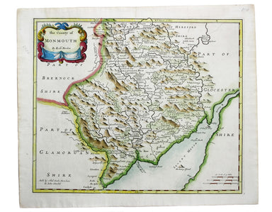
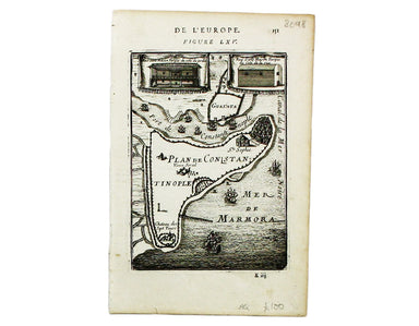
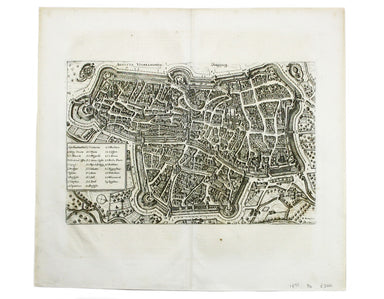
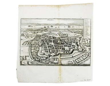
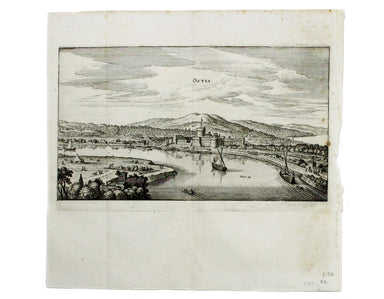
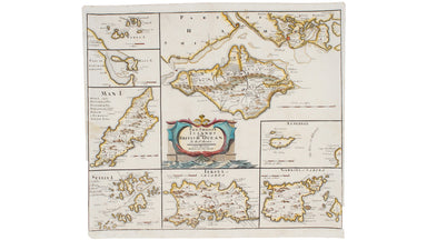
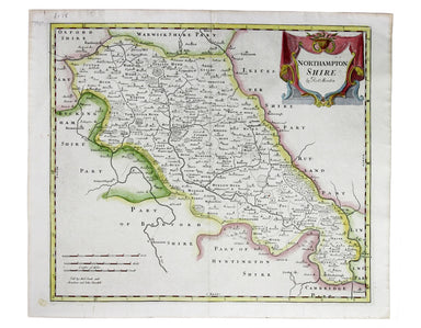
Maitland's Ward Plan of Cheap
Cheap Ward with its Divisions into Parishes according to a New Survey This ward plan of Cheap was published in the greatly expanded second edition ...
View full detailsCheap Ward with its Divisions into Parishes according to a New Survey This ward plan of Cheap was published in the greatly expanded second edition ...
View full detailsBaynard’s Castle Ward [and] Faringdon Ward with their divisions into Parishes according to a new survey This was plan of Baynard’s Castle and Farin...
View full detailsCheap Ward with its divisions into Parishes according to a new survey This ward plan of Cheap was published in the greatly expanded second edition ...
View full detailsTower Street Ward with their [sic] divisions into Parishes according to a new survey This plan of Tower Street was published in the greatly expande...
View full detailsThis map of the continent of Africa is from Mallet’s Description de l’Univers, first published in Paris in 1683 and reprinted with German text in F...
View full detailsThis map of Alexandria is from Mallet’s Description de l’Univers, first published in Paris in 1683 and reprinted with German text in Frankfurt the ...
View full detailsThis map of Ancient Jerusalem is from Mallet’s Description de l’Univers, first published in Paris in 1683 and reprinted with German text in Frankfu...
View full detailsThis map of Cairo is from Mallet’s Description de l’Univers. It derives, ultimately, from Matteo Pagano’s magnificent 21 sheet wall map, published ...
View full detailsThis view of Constantinople isfrom Mallet’s Description de l’Univers, first published in Paris in 1683 and reprinted with German text in Frankfurt ...
View full detailsThis map of Italy is from Mallet’s Description de l’Univers, first published in Paris in 1683 and reprinted with German text in Frankfurt the follo...
View full detailsThis map of Sicily is from Mallet’s Description de l’Univers, first published in Paris in 1683 and reprinted with German text in Frankfurt the foll...
View full detailsRome Ancienne This plan of ancient Rome is from Mallet’s Description de l’Univers, first published in Paris in 1683 and reprinted with German text ...
View full details
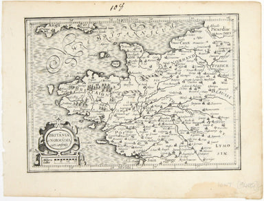
This plan of Constantinople is from Mallet’s Description de l’Univers, first published in Paris in 1683 and reprinted with German text in Frankfurt...
View full detailsMechelin, or Malines, the Capital of one of the ten Provinces of the Netherlands in Brabant This map of Mechelen was engraved by James Basire and p...
View full detailsCondition & Materials Copper engraving, 39.5 x 49.5 cm, engraved by J. Basire, black and white as issued, blank verso; map of Mons.
This map shows the ‘Germanic’ regions of Europe, including the Low Countries, Poland and Austria, engraved by Pieter van den Keere. The 'Atlas Mino...
View full detailsL’Isle de France, Parisiensis Ager The historic Île-de-France region is to the north of Paris (the modern province has Paris at its centre). The 'A...
View full detailsPomerania, running along the Baltic coast between Rostock and Gdansk, is now divided between Germany and Poland. The 'Atlas Minor’ was a pocket atl...
View full detailsAnglesey Ins[ula]; Wight ol[im] Vectis; Ins[ula] Garnsey; Ins[ula] Iarsay This map of Anglesey, the Isle of Wight, Guernsey and Jersey was engraved...
View full detailsBritannia et Normandia cum consiniis This map of Brittany and Normandy was engraved by Jodocus Hondius for the ‘Atlas Minor’. Condition & Mater...
View full detailsThis map shows the ‘Germanic’ regions of Europe, including the Low Countries, Poland and Austria, and was engraved by Jodocus Hondius for the ‘Atla...
View full detailsThis map of the province of Groningen in the Netherlands, set within an elaborate strapwork border, was published in the ‘Atlas Minor’. A new serie...
View full detailsThis plan of Loreto (site of the Basilica della Santa Casa) was published by Merian and his heirs in various works, including the Itinerarium Itali...
View full detailsThis plan of Messina was published by Merian and his heirs in various works, including the Itinerarium Italiae of 1640 and editions of the Theatrum...
View full detailsThis map of Augsburg was published by Merian and his heirs in various works, including the Archontologia cosmica, Theatrum Europaeum and the Topogr...
View full detailsThis map of Gallipoli in Apulia was published by Merian and his heirs in various works, including the Itinerarium Italiae of 1640, the Archontologi...
View full detailsThis map of Lyons was published by Merian and his heirs in various works, including the Archontologia Cosmica and Theatrum Europaeum. Condition &am...
View full detailsThis map of Stade was published by Merian and his heirs in various works, including the Theatrum Europaeum. Condition & Materials Copper engrav...
View full detailsThis map of Wismar was published by Merian and his heirs in various works, including the Theatrum Europaeum. Condition & Materials Copper engr...
View full detailsThis plan of of Ostia was published by Merian and his heirs in various works, including the Itinerarium Italiae of 1640, the Archontologia cosmica ...
View full detailsThis is a view of the Solfatara volcanic crater, mythological home of Vulcan in the Phlegraean Fields at Pozzuoli, near Naples. It was published by...
View full detailsRobert Morden's maps were engraved to illustrate Gibson's edition of William Camden's Britannia, first published in 1695 and reprinted in 1722 and ...
View full detailsRobert Morden's maps were engraved to illustrate Gibson's edition of William Camden's Britannia, first published in 1695 and reprinted in various e...
View full detailsRobert Morden's maps were engraved to illustrate Gibson's edition of William Camden's Britannia, first published in 1695 and reprinted in various 1...
View full detailsCondition & Materials Copper engraving, 36 x 42 cm, recent hand-colour, spotting top left, blank verso. A map of Essex engraved to accompany Gi...
View full detailsThis map of Lincolnshire was engraved to accompany Gibson’s edition of Camden’s Britannia, first published in 1695. Condition & Materials Coppe...
View full detailsThis map of Monmouthshire was engraved to accompany Gibson’s edition of Camden’s Britannia, first published in 1695. Condition & Materials Copp...
View full detailsA New and Correct Map of North Wales Robert Morden's maps were engraved to illustrate Gibson's edition of William Camden's Britannia, first publish...
View full detailsRobert Morden's map of Northumberland was engraved to illustrate Gibson's edition of William Camden's Britannia, first published in 1695 and reprin...
View full detailsThis map of Shropshire was engraved to accompany Gibson’s edition of Camden’s Britannia, first published in 1695. Condition & Materials Copper ...
View full detailsThis of Cape Verde was published 'Geography Rectified' in various editions from 1680 onward. Condition & Materials Copper engraving, 11.5 x 13...
View full detailsThis map of Middlesex is illustrated with vignettes of Buckingham Palace (before its early 20th century re-modelling) and the ‘new’ Houses of Parli...
View full detailsOriginally published in the series ‘Twenty-Four Views in Hindostan’, a part-work issued 1802-1805 to illustrate Francis Blagdon’s ‘Brief History of...
View full detailsKriechich Wyssenburg This map of Belgrade showing the confluence of the rivers Danube and Sava at Belgrade, Serbia, is from Sebastian Münster's Cos...
View full detailsThis view of the Latvian capital Riga is fromfrom Sebastian Münster's Cosmographia. A compendium of topographical information, folklore and travels...
View full detailsThis map of Scandinavia is from Sebastian Münster's Cosmographia. A compendium of topographical information, folklore and travels, it was first pub...
View full details