

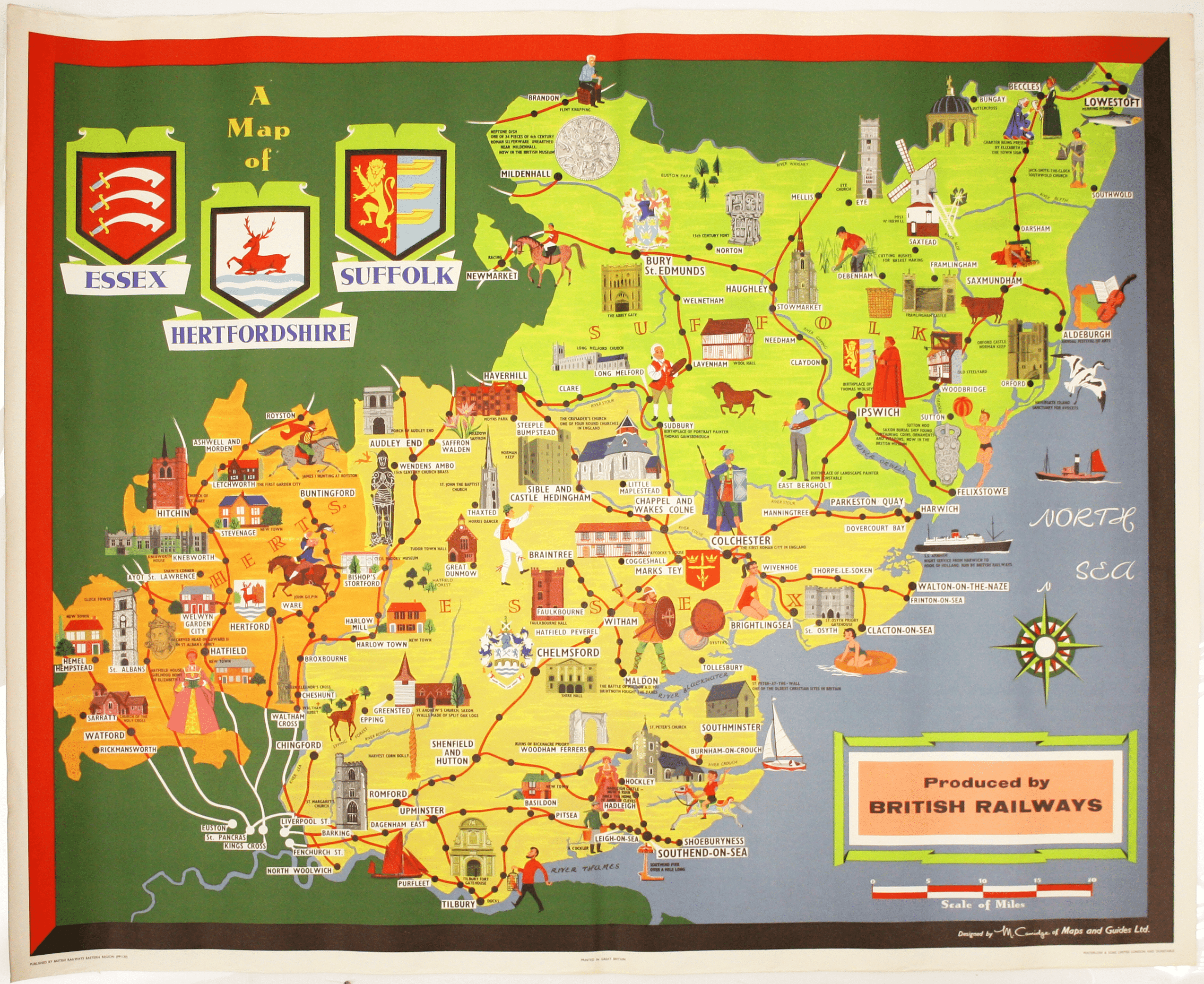
Camidge’s British Railways Pictorial Map of Essex, Hertfordshire & Suffolk
SKU: 9261
Title:
Camidge’s British Railways Pictorial Map of Essex, Hertfordshire & Suffolk
Date of publication:
Printed Measurement:
Publisher:
Colour:
This pictorial map grouping the three counties northeast of London was published by British Railways (Eastern Region) to promote leisure travel just before the Beeching cuts.
For example, the map advises reaching the Aldeburgh Festival of Music and Arts by rail, using the branch line from Saxmundham: the Beeching Axe put a stop to that in 1966. Read more
A varied range of activities are on offer for visitors, including sunbathing, racing and flint knapping, but the emphasis is on historical figures and buildings. Some are very well known, such as Elizabeth I (who is shown at Hatfield, where she learned she was to be Queen), but some are wonderfully eclectic and labelled with precision. For example, I did not know that the round church at Little Maplestead is one of only four in the country. The map is deceptively simple: you will learn, and you might get an idea for an interesting day out – although whether or not you can get there by train these days is another matter entirely.
The artist signs as 'M. Camidge'; her original artwork for this poster, painted in oils, is held by the National Railway Museum, but the only biographical information currently on offer is 'active 1960, poster artist, British?' However, I think we can be reasonably sure of our attribution to Mary Camidge.
The NRM also holds the artwork to another poster produced for British Railways (Eastern Region) in 1960, a pictorial map of Lincolnshire by M Sims. Both artists describe themselves as being 'of Maps and Guides, Ltd', establishing a link.
Mary Camidge and Mary Sims collaborated on the illustration of a number of children's books in the 1960s and 1970s, for example: Behold the Land: a Pictorial Atlas of the Bible (1963); Founders of Europe (1964); Peoples of the World in Colour (1964); The New Testament and its Background' (1977) and Antique Personal Possessions to Collect (1980).
There is a cartographic component to some of these, and the style is a reasonable match. There are also other instances where they chose to work independently, for example a pictorial map of London produced for Maps and Guides Ltd/Golden Galleon Press by Mary Sims c. 1960 (it features the British Railways 'lion and wheel' crest in use 1956-1965).
In 1977 Mary Sims and Mary Camidge established the Portman Bookstore, Portman House, Brodrick Road, SW17. Despite the name it wasn't an open shop: it was listed in Sheppard's directory of book-dealers as private premises, open by appointment. The business specialised in children's and illustrated books, 'annuals, comics and cinema'. Mary Camidge was still listed, though alone, in the 1995 edition.
Condition & Materials
Quad royal station poster, 40 x 50 inches (101.5 x 127 cm), printed in colours, blank verso. Read less