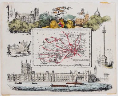
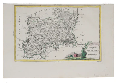
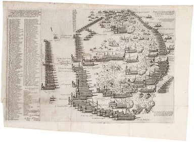
Langenes' Miniature Map of the Maluku Islands
Moluccae Insulae This map shows the Maluku Islands (or Moluccas), part of the volcanic Indonesian archipelago known to contemporary Europeans as th...
View full details
Moluccae Insulae This map shows the Maluku Islands (or Moluccas), part of the volcanic Indonesian archipelago known to contemporary Europeans as th...
View full details
Also published in Stanford’s London Atlas, our example of this map of Africa was separately issued and illustrates the speed and scale of the Scram...
View full details
The Daily Mail Special Map Of The Far East Produced to illustrate the Russo-Japanese War, this map indicates Treaty Ports, dockyards and naval base...
View full details
Plan Routiere de la Ville et Fauxbourgs de Paris divisé en douze Maries, revu et corrigé par Hérisson, géographe Our map shows the Paris of Charles...
View full details
Théâtre de la Guerre: Carte de l’Empire Ottoman en Europe et en Asie With an inset of Sevastopol, our map covers the region at the outbreak of the ...
View full details
Cary’s new map of England and Wales, with part of Scotland. On which are carefully laid down All the Direct and Principal Cross Roads the Course of...
View full details
Hoyle’s games improved; being practical treatises on whist, quadrille, piquet, chess, back-gammon, draughts, cricket, Tennis, Quinze, Hazard, Lansq...
View full details
[Greek title:] Biblos tes demosias euches... James Duport’s translation was first published in 1665 and adapted from the 1638 translation of Elias ...
View full details
Poems on several occasions. Written by the Reverend John Donne, D. D. Late Dean of St. Paul’s. With elegies on the author’s death. To this edition...
View full details
A Shooting Trip to Kamchatka The immensely wealthy Count Elim Pavlovich Demidov, third Prince of San Donato, was the Russian Empire's last ambassad...
View full details
Opera In tres Tomos divisa, Cum integris Notis Servii, Philargyrii, nec non J. Pierii Variis Lectionibus, & Selectissimis plerisque Commentarii...
View full details
Myriobiblon e Bibliotheke [Greek title] ... Graece edidit David Hoeschelius ... Latine vero redidit et scholiis auxit Andreas Schottus This book is...
View full details
This steamship route map of the western Mediterranean and Northwest Africa shows the routes from Marseille and Bordeaux to Tunisia, Algeria and Mor...
View full details
This anthropomorphic map of Ireland was published in “Geographical Fun: Being Humorous Outlines of Various Countries”. Though credited on the title...
View full details
Though credited on the title-page under his pen-name ‘Aleph’, William Harvey himself gives all the credit for this series of comic maps to a “young...
View full details
Though credited on the title-page under his pen-name ‘Aleph’, William Harvey himself gives all the credit for this series of comic maps to a “young...
View full details
Thus anthropomorphic map of Holland and Belgium was published in “Geographical Fun: Being Humorous Outlines of Various Countries.”. Though credited...
View full details
The British Empire Exhibition originally ran between April and November 1924, but it was not a financial success, and the decision was taken to reo...
View full details
The British Empire Exhibition was, at the time, the largest exhibition staged anywhere in the world; a high profile, postwar statement of confidenc...
View full details
This route map advertises passenger, postal and cargo steamship services between Marseille and West Africa. The SS Canada was built for the Fabre L...
View full details
Our journey to Hythe begins in London and follows the road through East Peckham and Eltham, reaching Hythe via Maidstone. Thousands of miles of roa...
View full details
Our journey to Dover begins in London and follows the road through Deptford, Blackheath, Shooter’s Hill, and Dartford, reaching Dover via Rochester...
View full details
Our journey takes us along the road between the university towns of Oxford and Cambridge, via Bedford. Thousands of miles of roads were surveyed fo...
View full details
Our journey begins in London and follows the road west through Knightsbridge and Kensington (with Hyde Park to one side), Hammersmith and Turnham G...
View full details
This map of the British Isles is aligned with west at the top of the map and north on the right, which makes better use of the available space on t...
View full details
This 'carte à figure' map of Italy includes eight costume vignettes and six city views around the edges, with the coats of arms of Corsica and Sard...
View full details
This is one of the earliest obtainable views of Venice, derived from a larger woodcut by Dutch artist Erhard Reuwich, which was published in the fi...
View full details
This is one of the earliest obtainable views of Florence, derived from a lost engraving by Francesco Rosselli. The woodcuts were created in the wor...
View full details
This anthropomorphic map depicting Wales as "Owen Glendowr, in Bardic grandeur" is from 'Geographical Fun: Being Humorous Outlines of Various Count...
View full details
Humoristiche satyrische Karte von Kriegsschauplatze This Austrian pictorial map satirising the Crimean War was published in July 1854 in No. 55 the...
View full details
The cartouche on this map of the British isles is surmounted by the old Stuart coat of arms and the borders are made up of sixteen regional armoria...
View full details
This road map includes London, Islington, and Highgate, and extends as far as Towcester. It was published as sheet 21 in the 1698 folio edition of ...
View full details
L’ordine et vera dispositione che tenero le galere de l’armata della Santa lega nel conflito navale ali 7 ottob. 1571 giorno de S.agiustina a cuzzo...
View full details
John Thomson's map of Korea and Japan was engraved by John and George Menzies in 1814 and published in his ‘New General Atlas’ in 1815. Walter sugg...
View full details
The Argonautica illustrates the mythical voyage of Jason and the Argonauts in their quest for the Golden Fleece. The map shows Black Sea and easter...
View full details
Plan Des Antiquitez De Rome, Représentées Et Distinguées Suivant La Situation De Chacun De Ses Anciens Monuments / Roma Vetus This map of Rome is a...
View full details
This map of Morocco was one of only two original maps engraved by the son of Johann Baptist Homann, Johann Christoph, in his short life (1701-30). ...
View full details
This attractive, detailed map of the county of Middlesex is unsigned; as yet, we have been unable to identify the engraver. Do feel free to write t...
View full details
Ellis' map of Middlesex conveys a wealth of detailed information: borough towns are shown with stars identifying the number of Members returned to ...
View full details
This map of Middlesex included a vignette of St. Paul's Cathedral. It was published in James Bell’s 'New and Comprehensive Gazetteer of England and...
View full details
This map of Middlesex was published in Reuben Ramble's ‘Travels through the Counties of England’, an uncommon county atlas for children. Reuben Ram...
View full details
This map of Middlesex was engraved by Giuliano Zuliano after Giovanni Pitteri and published in Antonia Zatta's ‘Atlante Novissimo’. This was his ...
View full details
Pas-Caart van de Oost Zee Verthoonende alle de Ghelegentheydt tusschen t'Eylandt Rugen ende Wyborg From one of the finest Dutch marine atlases of t...
View full details
Condition & Materials Circular folding map of the environs of Paris, 79 x 79 cm, engraved by Barrière (Pére) after Bariolle, black and white, d...
View full details
Folding map showing the post roads of the Austro-Hungarian Empire. Condition & Materials 4 folding engraved map sheets, which can be joined, e...
View full details
This map of Central America was engraved by John Rapkin for John Tallis' popular ‘Illustrated Atlas’. It includes black and white vignettes of Beli...
View full details
This map of Nova Scotia was engraved by John Rapkin for John Tallis' popular ‘Illustrated Atlas’; it includes black and white vignettes of Halifax,...
View full details
The map of the Eastern Hemisphere tracks the overland route to India (subject of a separate map in the series) and on to Australia. John Tallis the...
View full details