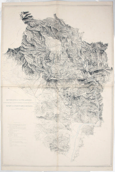
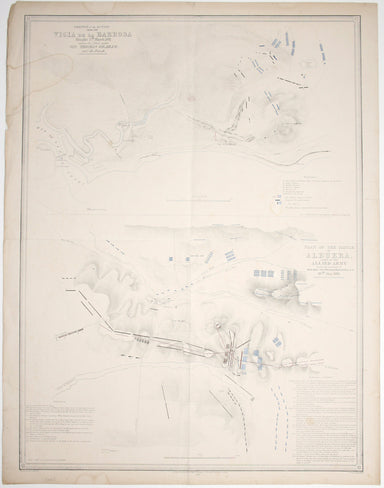
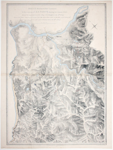
Walter Blackie’s Map of Africa
This map of Africa was drawn and engraved by Edward Weller, and includes insets of Mauritius, Réunion and Natal, Some of the most recent geographi...
View full details
This map of Africa was drawn and engraved by Edward Weller, and includes insets of Mauritius, Réunion and Natal, Some of the most recent geographi...
View full details
First published in 1914, this revised edition highlights administrative boundaries. Though technically administered jointly by Egypt and Britain be...
View full details
In the 1920s Valletta was the location of the Royal Navy's Mediterranean Fleet's headquarters. Prepared on the island, this map of Malta has a grid...
View full details
Graeciae Pars Meridionalis / Graciae Antiquae Tabula Nova in qua locorum situs tum ad distantias itinerarias tum ad Observationes Astronomicas exac...
View full details
Condition & Materials Copper engraving, 28.5 x 35 cm, original hand-colour map of the Duchy of Lorraine, blank verso.
This map of the Principality of Lüneburg incorporates the former County of Dannenberg. The cartouche illustrates a stag hunting scene, perhaps on ...
View full details
Map of India, constructed with great care and research from all the Latest Authorities and intended more particularly to facilitate a reference to ...
View full details
This map of America is from Wyld's New General Atlas. James Wyld senior established a highly successful firm of map publishers, which passed to his...
View full details
This map of Denmark is from Wyld's New General Atlas. James Wyld senior established a highly successful firm of map publishers, which passed to his...
View full details
This map of Scandinavia is from Wyld's New General Atlas. James Wyld senior established a highly successful firm of map publishers, which passed to...
View full details
Spain and Portugal. Reduced from the large map in four sheets James Wyld senior established a highly successful firm of map publishers, which passe...
View full details
Movements of the two armies after the repulse of Marshall Massena’s attack upon the position of Bussaco This map was lithographed by AR Grive and p...
View full details
Sketch of the action near the Vigia de la Barrosa fought 5th March, 1811 between the allied armies under Sir Thomas Graham, and the French […] Plan...
View full details
Sketch illustrative of the operations in the vicinity of Bayonne during the winter of 1813. Against the Light Division at the village of Arcangues ...
View full details
Map of the Netherlands including the Grand Duchy of Luxembourg. With the post roads and stations and the limites of Holland and Belgium This map of...
View full details
This map of Middlesex was engraved by Giuliano Zuliano after Giovanni Pitteri and published in Antonia Zatta's ‘Atlante Novissimo’. This was his ...
View full details
Signed limited edition screenprint Colour screenprint, sheet size 78 x 57.5 cms, signed by the artist and inscribed 'AP' (Artist’s Proof) in pencil...
View full details