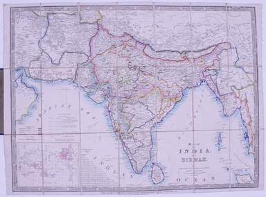
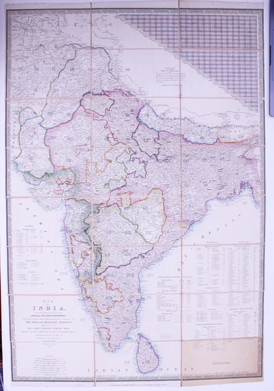
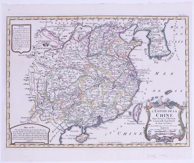
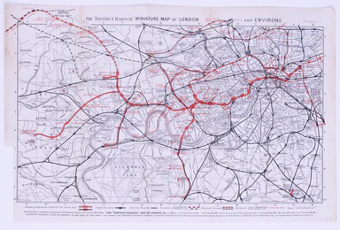
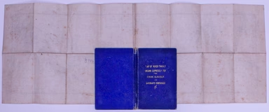
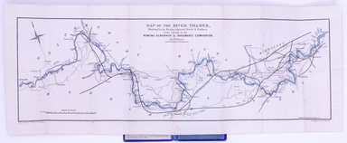
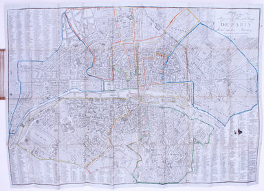
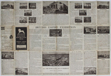
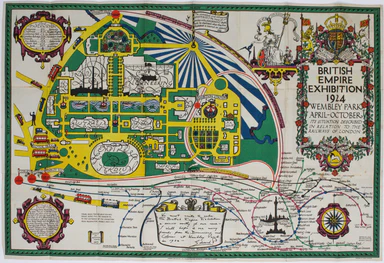
Speed's Map of Huntingdonshire
Huntington, both shire and shire towne with the ancient citie Ely described This is an unusual example of John Speed’s map of Huntingdonshire – it ...
View full details
Huntington, both shire and shire towne with the ancient citie Ely described This is an unusual example of John Speed’s map of Huntingdonshire – it ...
View full details
Olissippo quae nunc Lisboa, civitas amplissima Lusitaniae, ad Tagum, totius Orientis, et multarum Insularum Aphricaeque et Mericae emporium nobilis...
View full details
Sheets 44E/44F: North Sumatra and part of Siam/Part of Siam, Malaya and East Sumatra For the highly classified production of Escape & Evasion m...
View full details
Cloth Survival Chart S-12: Western Pacific Covering the Western Pacific, this is the largest of the US Navy ‘handkerchief’ charts. One side shows ...
View full details
This is the index map and key to the Ordnance Survey sheets covering the entire county Tyrone on a scale of six inches to the mile. Condition &...
View full details
This is the index map and key to the Ordnance Survey sheets covering the entire county Armagh on a scale of six inches to the mile Condition & ...
View full details
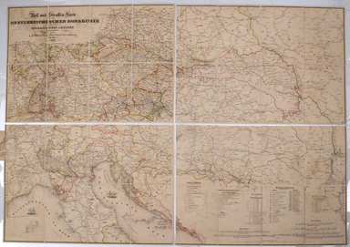
This issue of Beck’s 1934 map saw a slight increase in size of the card folder given away to passengers. Beck’s diagram is one of the most innovat...
View full details
Our map of the London underground is the second edition in a series designed by Fred Stingemore, issued free to passengers from May 1925 onwards an...
View full details
Map of India and Birmah This map of India and Burma features an inset location map with British possessions coloured red, next to a distance table...
View full details
Map of India, constructed with great care and research from all the Latest Authorities and intended more particularly to facilitate a reference to ...
View full details
Map of China, Japan and Korea. / [Cover title:] The Eastern Crisis. Bacon's large-scale map of Japan, Korea, China, Manchuria Produced to illustrat...
View full details
Chine du nord - Corée - Manchoukouo Manchukuo – a Japanese term for Manchuria – was a puppet state of the Empire of Japan in China and Inner Mongol...
View full details
This is a separately issued example of a map of Ireland which also appeared in Arrowsmith’s major work, his influential ‘London Atlas of Universal ...
View full details
Portus Pulchri in Isthmo Panamensi [with] Scenographia Portus Pulchri This is a plan and view of the successful British attack on the wealthy and s...
View full details
This map of Tehran features a legend in the borders listing 218 places of interest in the pre-Revolutionary city. The mapmaker’s own premises are i...
View full details
Souvenir Map of the Coronation procession May 12th, 1937. This decorated Map is drawn to mark the Royal Procession of Their Majesties Coronation......
View full details
Paul Bunyan's pictorial map of the United States depicting some of his deeds and exploits Stories about Paul Bunyan, the lumberjack of gigantic pr...
View full details
This map of the environs of Edinburgh was published a decade before Ainslie’s landmark nine sheet map of Scotland. Originally published in 1778, th...
View full details
After a lonely and hazardous journey (especially after he quarrelled and parted company with Major Stephen Long’s expedition) Beltrami (1779-1855) ...
View full details
Robert Morden's county maps, like this one of Cornwall, were engraved to illustrate Gibson's edition* of William Camden's Britannia. Camden was an ...
View full details
Robert Morden's country maps, like this one of Suffolk, were engraved to illustrate Gibson's edition* of William Camden's Britannia. Camden was an ...
View full details
Robert Morden's county maps, like this one of Surrey, were engraved to illustrate Gibson's edition* of William Camden's Britannia. Camden was an El...
View full details
Plan du Port et de la Ville de Nangasaki This is a plan of the port city of Nagaski, one of Japan’s chief points of contact with the outside world ...
View full details
Carte de Isles du Japont et la presqu' Isle de Coree avec les costes de la Chine depuis Pekin jusqua Canton . . . Bellin compiled maps like this on...
View full details
L’Empire du Chine pour servir a l’Histoire Universelle, d’une Societe de Gens de Lettres Our example of Bellin’s map of China, with text in French ...
View full details
Thousands of miles of roads were surveyed for John Ogilby’s pioneering road atlas, the ‘Britannia’. The decorative cartouche on this map of the roa...
View full details
Thousands of miles of roads were surveyed for John Ogilby’s pioneering road atlas, the ‘Britannia’. This sheet shows the roads between the Cumbrian...
View full details
Thousands of miles of roads were surveyed for John Ogilby’s pioneering road atlas, the ‘Britannia’. This sheet covers the road between High Barnet ...
View full details
The “District Railway” Miniature Map of London and Environs (6th edition) District Railway routes are overprinted in red on this road and rail map ...
View full details
Map of the River Thames, shewing locks, bridges, adjacent roads & railways, drawn expressly for the Rowing Almanack & Oarsman’s Companion T...
View full details
Chorographia Terrae Sanctae in angustiorem formam redacta, et ex variis auctoribus a multibus erroribus expurgata This map of the Holy Land, after ...
View full details
This pictorial route map of the Devon General by an anonymous draughtsman for the principal bus operator in south Devon makes playful references to...
View full details
This Vietnam War-era city plan of Saigon (modern Ho Chi Minh City) is coloured by district, with a street index at the foot of the map. Useful info...
View full details
Moluccae Insulae This map shows the Maluku Islands (or Moluccas), part of the volcanic Indonesian archipelago known to contemporary Europeans as th...
View full details
Also published in Stanford’s London Atlas, our example of this map of Africa was separately issued and illustrates the speed and scale of the Scram...
View full details
Plan Routiere de la Ville et Fauxbourgs de Paris divisé en douze Maries, revu et corrigé par Hérisson, géographe Our map shows the Paris of Charles...
View full details
Théâtre de la Guerre: Carte de l’Empire Ottoman en Europe et en Asie With an inset of Sevastopol, our map covers the region at the outbreak of the ...
View full details
Cary’s new map of England and Wales, with part of Scotland. On which are carefully laid down All the Direct and Principal Cross Roads the Course of...
View full details
This steamship route map of the western Mediterranean and Northwest Africa shows the routes from Marseille and Bordeaux to Tunisia, Algeria and Mor...
View full details
This anthropomorphic map of Ireland was published in “Geographical Fun: Being Humorous Outlines of Various Countries”. Though credited on the title...
View full details
Though credited on the title-page under his pen-name ‘Aleph’, William Harvey himself gives all the credit for this series of comic maps to a “young...
View full details
Though credited on the title-page under his pen-name ‘Aleph’, William Harvey himself gives all the credit for this series of comic maps to a “young...
View full details
Thus anthropomorphic map of Holland and Belgium was published in “Geographical Fun: Being Humorous Outlines of Various Countries.”. Though credited...
View full details
The British Empire Exhibition originally ran between April and November 1924, but it was not a financial success, and the decision was taken to reo...
View full details
The British Empire Exhibition was, at the time, the largest exhibition staged anywhere in the world; a high profile, postwar statement of confidenc...
View full details
This route map advertises passenger, postal and cargo steamship services between Marseille and West Africa. The SS Canada was built for the Fabre L...
View full details
Our journey to Hythe begins in London and follows the road through East Peckham and Eltham, reaching Hythe via Maidstone. Thousands of miles of roa...
View full details
Our journey to Dover begins in London and follows the road through Deptford, Blackheath, Shooter’s Hill, and Dartford, reaching Dover via Rochester...
View full details