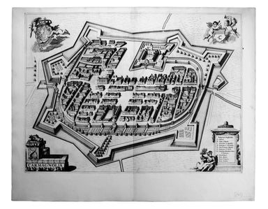
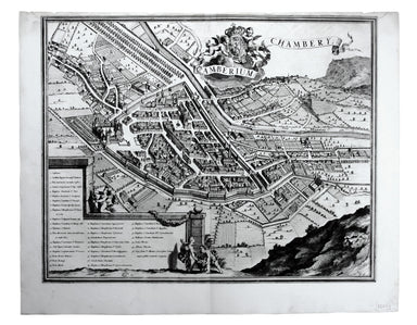
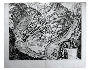
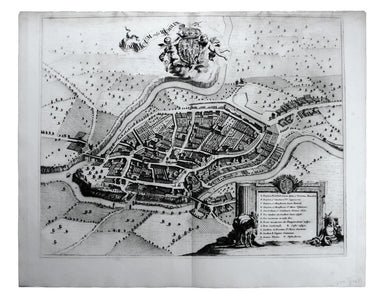
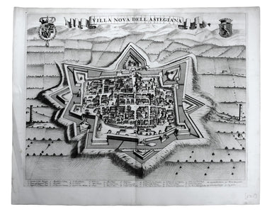
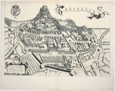
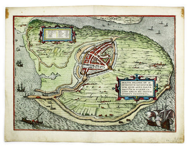
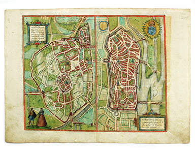
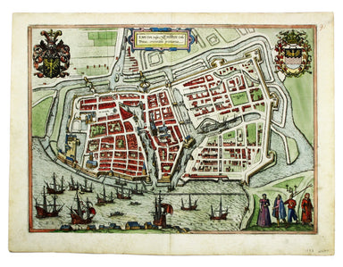
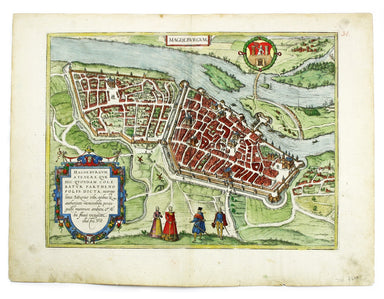
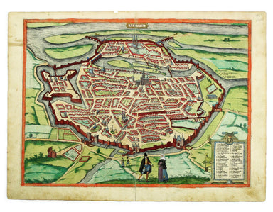
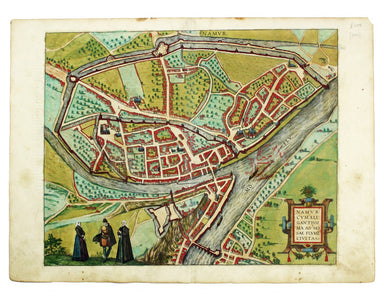
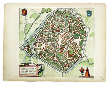
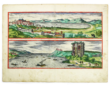
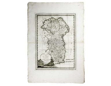
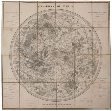
Blaeu’s Plan of Carmagnola
Carmagnola, just south of Turin in Piedmont, was fought over and extensively remodelled in the mid seventeenth-century; it was briefly recaptured b...
View full details
Carmagnola, just south of Turin in Piedmont, was fought over and extensively remodelled in the mid seventeenth-century; it was briefly recaptured b...
View full details
Camberium / Chambery Blaeu’s townbook of Savoy and Piedmont was first published by the Blaeu heirs in 1682, but the plates were purchased and reiss...
View full details
This map of Demonte in Piedmont was engraved by Juvenal Boetto. Blaeu’s townbook of Savoy and Piedmont was first published by the Blaeu heirs in 16...
View full details
Moustiers Blaeu’s townbook of Savoy and Piedmont was first published by the Blaeu heirs in 1682, but the plates were purchased and reissued (with B...
View full details
Rumiliacum vulgo Rumilly Blaeu’s townbook of Savoy and Piedmont was first published by the Blaeu heirs in 1682, but the plates were purchased and r...
View full details
Exigua & celeberrima Verruca […] This is a map of Verrua Savoia, north east of Turin in Piedmont. Blaeu’s townbook of Savoy and Piedmont was fi...
View full details
Villa Nova dell’ Astegiana This is a map of Villanova d’Asti, in Piedmont. Blaeu’s townbook of Savoy and Piedmont was first published by the Blaeu ...
View full details
This is a map of Revello, near Cuneo in Piedmont. Blaeu’s townbook of Savoy and Piedmont was first published by the Blaeu heirs in 1682, but the pl...
View full details
Blome published the first new series of county maps in the sixty years since the appearance of John Speed’s ‘Theatre’. In the straightened financia...
View full details
Blome published the first new series of county maps since Speed. In the straightened financial environment of post-Restoration London he had to rep...
View full details
Blome published the first new series of county maps in the sixty years since the appearance of John Speed’s ‘Theatre’. In the straightened financia...
View full details
[Greek title:] Biblos tes demosias euches... James Duport’s translation was first published in 1665 and adapted from the 1638 translation of Elias ...
View full details
An Accurate Map of the County Palatine of Chester […] Condition & Materials Copper engraving, 41.5 x 50.5 cm, map of Cheshire with original han...
View full details
Bowen’s New General Map of America appeared in a number of publications, and features widely held cartographic misconceptions of the time, such as ...
View full details
A New and Correct Map of the Countries Twenty Miles round London Condition & Materials Copper engraving, 34 x 39 cm, recent hand-colour, blank ...
View full details
An accurate map of the County of Worcester divided into its hundreds and drawn from the best authorities. Illustrated with historical extracts rela...
View full details
Bradshaw’s map of the railways of England & Wales with part of Scotland, reduced from the highly accurate Ordnance Survey, presented to the sub...
View full details
Bradshaw’s Railway Manual, Shareholder’s Guide and Official Directory for 1868. Containing the History and Financial Position of Every Company, Bri...
View full details
Brilium, Holandiae Opp. Ob Intestinum Batavicum Bellum, Quod Anno Partae Salutis, M.D.LXXII. Calend Aprlis, Hic Initium Sumpsit, Famosum. [Brielle,...
View full details
This map of Limbourg or Limburg is from the Civitates Orbis Terrarum, one of the most significant cartographic works of the late sixteenth-century,...
View full details
This map of Mons in Belgium is from the Civitates Orbis Terrarum, one of the most significant cartographic works of the late sixteenth-century, pri...
View full details
This map of Mons in Belgium is shown with Arras in northern France. It is from the Civitates Orbis Terrarum, one of the most significant cartograph...
View full details
This map includes French town plans after Belleforest on one sheet: Autun in Burgundy and Nevers in Bourgogne. They are from the Civitates Orbis Te...
View full details
Brunopolis [with] Luneburgum [and] Brema [and] Aldenburgum Holsatiae Four north German towns are shown here on one sheet: Braunschweig, Lüneburg an...
View full details
This plan of Douai (Duacum) in northern France was published in the Civitates Orbis Terrarum, one of the most significant cartographic works of the...
View full details
Emuda vulgo Embden A plan of Emden in northern Germany. The Civitates Orbis Terrarum was one of the most significant cartographic works of the lat...
View full details
Fribergum Misinae The Civitates Orbis Terrarum was one of the most significant cartographic works of the late sixteenth-century, printed over 45 ye...
View full details
Magdeburgum, a Venere quae hic quondam colebatur Parthenopolis dicta, metropolitica Saxoniae urbs The cartouche on this plan of Magdeburg refers to...
View full details
This plan of Metz in northeastern France is from the Civitates Orbis Terrarum, one of the most significant cartographic works of the late sixteenth...
View full details
This plan of Namur in Belgium is from the Civitates Orbis Terrarum, one of the most significant cartographic works of the late sixteenth-century, p...
View full details
This plan of Tienen in Flanders is from the Civitates Orbis Terrarum, one of the most significant cartographic works of the late sixteenth-century,...
View full details
This plan of Valenciennes in northern France is from the Civitates Orbis Terrarum, one of the most significant cartographic works of the late sixte...
View full details
Wesalia in Ducatu Clivensi Urbs Clara Opibus The Civitates Orbis Terrarum was one of the most significant cartographic works of the late sixteenth...
View full details
Views of two towns on the Bay of Naples, Pozzuoli and Baia, are here presented on one sheet. The Civitates Orbis Terrarum was one of the most signi...
View full details
The first part of this work details the construction of semi-permanent bridges at Arnhem, Xanten, Rees and Spyck. The second part covers the equall...
View full details
Port Louis is the capital and principal port of Mauritius, which remained a British colony until 1968. Condition & Materials Engraved British c...
View full details
Sheets 44E/44F: North Sumatra and part of Siam/Part of Siam, Malaya and East Sumatra For the highly classified production of Escape & Evasion m...
View full details
Town Plan of Wien (Vienna) – Second Edition –- Sheet 5 (Central) The Prater Park with its famous giant wheel is a fraction to the east of the city ...
View full details
The United Nations was established in October 1945, and Bullock’s map is a joyful celebration of what promised to be a more effective successor to ...
View full details
Cassell's 'immense map' of London, of which this is the central sheet, was prepared for the Weekly Dispatch and published in nine parts between Jan...
View full details
Cassell's 'immense map' of London, of which this is the south sheet, was prepared for the Weekly Dispatch and published in nine parts between Janua...
View full details
La Parte Orientale della Irlanda che comprende le Provincie di Ulster e Leinster This is the eastern sheet of Cassini’s pleasing and unusual two sh...
View full details
The Central London Railway pioneered giving maps like this one to passengers free of charge, something which we now take for granted but which only...
View full details
Plan Des Antiquitez De Rome, Représentées Et Distinguées Suivant La Situation De Chacun De Ses Anciens Monuments / Roma Vetus This map of Rome is a...
View full details
Map of the Grand Junction Railway and its Adjacent Country. [Copied by permission from the Company’s official map.] Shewing all the the stations on...
View full details
Condition & Materials Circular folding map of the environs of Paris, 79 x 79 cm, engraved by Barrière (Pére) after Bariolle, black and white, d...
View full details
Signed limited edition screenprint Colour screenprint, sheet size 78 x 57.5 cms, signed by the artist and inscribed 'AP' (Artist’s Proof) in pencil...
View full details
The East Coast of Scotland with the Isles of Orkney and Shetland This sea chart is from ‘Great Britain’s Coasting Pilot’, the first English Sea Atl...
View full details