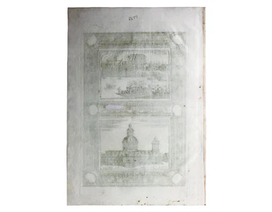
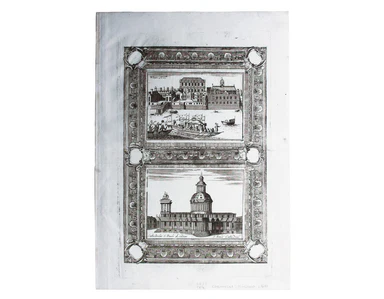
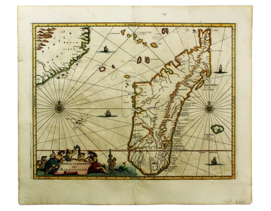
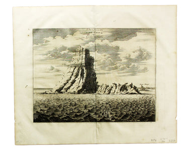
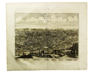
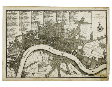
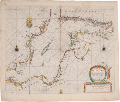
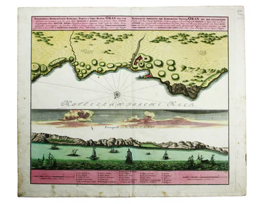
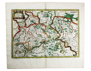
Coronelli’s Views of Whitehall & St Paul’s Cathedral
This view is from 'Isolario dell'Atlante Veneto', perhaps the last of the great Italian ‘island books’. If Coronelli’s St Paul’s differs somewhat f...
View full details
This view is from 'Isolario dell'Atlante Veneto', perhaps the last of the great Italian ‘island books’. If Coronelli’s St Paul’s differs somewhat f...
View full details
L’Espagne dressée sur la Description qui en a eté faite par Rodrigo Mendez Sylva… par G. de l’Isle/Nova Regni Hispaniae accurata descriptio… Thus ...
View full details
Carte de la Guerre de la Crimèe. Editèe par Lèmèrey et E. Gratier This Crimean War broadsheet map includes an inset of Sebastopol and a view of the...
View full details
The Daily Mail Special Map Of The Far East Produced to illustrate the Russo-Japanese War, this map indicates Treaty Ports, dockyards and naval base...
View full details
This pictorial map depicts various London ‘types’ in the borders, and shows the Royal Festival Hall (built for the 1951 Festival of Britain) and th...
View full details
The Daily Telegraph was one of a number of newspapers to sponsor London underground maps, like our example from 1919 which also includes the tramwa...
View full details
Insula S. Laurentii, vulgo Madagascar The name 'Isle of St Laurence' was given by the Portuguese, who landed on Madagascar on St Laurence's day (Fe...
View full details
Le Pik de Teneriffe/De Piek-Bergh op het Eilant Tenerifto The Anaga mountain range meets the sea in the northeastern part of Tenerife, close to the...
View full details
Dapper’s plan of Cairo follows Matteo Pagano’s magnificent 21 sheet wall map, published in Venice in 1549. Cairo was one of the great trading centr...
View full details
This map of the Dominion of Canada was made by John Bartholomew & Son for Dawson Brothers. It features insets of the environs of Montreal, New...
View full details
Plan Des Villes De Londres et de Westminster et leurs Faubourgs avec le Bourg de Southwark This is the first version of the map, before the date wa...
View full details
Parte Occidentale/Orientale del Governo Generale d’Orleans This map of the Duchy of Orleans is from Mercurio Geografico, an unusual and finely engr...
View full details
Tavola Esatta dell’antico Latio e Nova Campagna di Roma, situata sotto il quinto Clima […] Prepared by papal cartographer Innocenzo Mattaei circa 1...
View full details
Signed limited edition screenprint Colour screenprint, sheet size 78 x 57.5 cms, signed by the artist and inscribed 'AP' (Artist’s Proof) in pencil...
View full details
Signed limited edition screenprint Colour screenprint, sheet size 78 x 57.5 cms, signed by the artist and inscribed 'AP' (Artist’s Proof) in pencil...
View full details
London: Day & Son for FG Moon, 1842-45. Tinted lithograph by Louis Haghe after Roberts, 33 x 48.5 cm, minor spotting. From the first edition o...
View full details
Signed limited edition screenprint Colour screenprint, sheet size 78 x 57.5 cms, signed by the artist and inscribed 'AP' (Artist’s Proof) in pencil...
View full details
The District Railway Guide to the Greater Britain Exhibition, the Gigantic Wheel, &c, at Earls Court The Greater Britain Exhibition was one of ...
View full details
This District Railway map of Greater London shows the approximate extent from Epsom to Enfield and from Windsor to Grays, with inset of the Henley ...
View full details
Motus in Coelo Spirales This chart shows the irregular orbits of Mercury and Venus on Tycho Brahe’s model, as observed from Earth, for the years 17...
View full details
Voyage en ballon dirigeable a travers l’Europe No rule sheet, but fairly self explanatory: the board is a simplified map of Europe with vignettes o...
View full details
Map of the Great Western Railway and Connections This map illustrates how the Great Western Railway connected resources such as coal fields, china ...
View full details
[Greek title] Orestes. Adjecta est ad finem versio Latina, ex editione J. Barnes […] Glasguae [Glasgow], in Aedibus Academicis, excudebant Robertus...
View full details
Signed limited edition screenprint Colour screenprint, sheet size 78 x 57.5 cms, signed by the artist and inscribed 'AP' (Artist’s Proof) in pencil...
View full details
Antilles – Ile de la Grenade This detailed chart of Grenada was derived from British Admiralty surveys. Condition & Materials French naval char...
View full details
Antilles – Ile de Culebra ou du Passage This detailed chart of Isla Culebra (now an island-municipality of Puerto Rico) was derived from British Ad...
View full details
Théâtre de la Guerre: Carte de l’Empire Ottoman en Europe et en Asie With an inset of Sevastopol, our map covers the region at the outbreak of the ...
View full details
Metropolitan Goods Conference Map of Collection & Delivery Boundary This map is a variant of the London plan typically issued with Kelly’s Dire...
View full details
Blatt 29. Warmbad This map covers the Karas region in modern Namibia (then German South West Africa), which was the scene of one of the earliest at...
View full details
Indischer Ocea – Afrika, Ost Küst – Lindi-Bucht This Imperial German Naval Office chart shows sands, soundings etc, with interior detail of relief,...
View full details
Bismark Archipel – Neu Hannover This is a German chart of New Hanover Island or Lavongai in the Bismarck Archipelago of Papua New Guinea. German Ne...
View full details
West Indien – Haïti bis Martinique This Imperial German Naval Office chart shows sands, soundings and interior detail of relief. Condition & Ma...
View full details
Stiller Ozean – Hermit Inseln This is a German chart of the Hermit Islands in the Bismarck Archipelago of Papua New Guinea. German New Guinea, a Ge...
View full details
Pas-Caart van de Oost Zee Verthoonende alle de Ghelegentheydt tusschen t'Eylandt Rugen ende Wyborg From one of the finest Dutch marine atlases of t...
View full details
This wartime souvenir handkerchief map of Europe was issued ‘by permission of the Manchester Guardian’, who printed the map over a full broadsheet ...
View full details
By Green Line from Hyde Park Corner This pair poster was issued in April 1947 for the start of the first summer of the fully re-instated coach netw...
View full details
Map of the County of Middlesex from an Actual Survey The Greenwood brothers were land-surveyors from Yorkshire who compiled one of the last indepen...
View full details
Map of the County of Surrey from an Actual Survey The Greenwood brothers were land-surveyors from Yorkshire who compiled one of the last independen...
View full details
Signed limited edition screenprint Colour screenprint, sheet size 78 x 57.5 cms, signed by the artist and inscribed 'AP' (Artist’s Proof) in pencil...
View full details
Hill's Los Angeles City Map and Tourist Guide This detailed city plan of Los Angeles is bordered by an extensive street index. A legend identifies ...
View full details
The history and topography of Ashbourn, the valley of the Dove and the adjacent villages; with biographical sketches of eminent natives &c This...
View full details
Hoyle’s games improved; being practical treatises on whist, quadrille, piquet, chess, back-gammon, draughts, cricket, Tennis, Quinze, Hazard, Lansq...
View full details
Scandinavia complectens Sveciae, Daniae et Norvegiae Regna ex novissimis subsidiis delineata et ad Leges Projectionis Stereographicae legitimae red...
View full details
Topographia Repraesentio Barbarici Portus et Urbis Munitae Oran … Oran, an important trading port and now Algeria’s second city, was governed by th...
View full details
This map of Morocco was one of only two original maps engraved by the son of Johann Baptist Homann, Johann Christoph, in his short life (1701-30). ...
View full details
Saxonia Inferior et Mecklenborg Duc The original Mercator Atlas (parts published from 1585 onwards) was not a commercial success; the copper printi...
View full details
Sheet C1 from Horwood’s ‘Plan of the Cities of London and Westminster…’ Horwood’s plan is a landmark in London mapping on a number of counts. It wa...
View full details
Sheet C4 from Horwood’s ‘Plan of the Cities of London and Westminster…’ Horwood’s plan is a landmark in London mapping on a number of counts. It wa...
View full details